Difference between revisions of "2023-02-24 58 6"
From Geohashing
([live picture]Solberg [https://openstreetmap.org/?mlat=58.59485420&mlon=6.04269600&zoom=16 @58.5949,6.0427]) |
(→Achievements) |
||
| (11 intermediate revisions by the same user not shown) | |||
| Line 12: | Line 12: | ||
| date=2023-02-24 | | date=2023-02-24 | ||
}}<!-- edit as necessary --> | }}<!-- edit as necessary --> | ||
| + | [[Image:20230224 58 6-Me.jpg|thumb|left]] | ||
== Location == | == Location == | ||
<!-- where you've surveyed the hash to be --> | <!-- where you've surveyed the hash to be --> | ||
| + | |||
| + | On the farm Solberg, Bjerkreim, Norway | ||
== Participants == | == Participants == | ||
<!-- who attended: If you link to your wiki user name in this section, your expedition will be picked up by the various statistics generated for geohashing. You may use three tildes ~ as a shortcut to automatically insert the user signature of the account you are editing with. | <!-- who attended: If you link to your wiki user name in this section, your expedition will be picked up by the various statistics generated for geohashing. You may use three tildes ~ as a shortcut to automatically insert the user signature of the account you are editing with. | ||
--> | --> | ||
| + | |||
| + | *[[User:Pica42|Pica42]] | ||
== Plans == | == Plans == | ||
| Line 24: | Line 29: | ||
== Expedition == | == Expedition == | ||
<!-- how it all turned out. your narrative goes here. --> | <!-- how it all turned out. your narrative goes here. --> | ||
| + | |||
| + | Today's trip was quite nice despite the fact that it was cold, it rained a little and it was quite windy. The trip from home was about 50 km each way to the farm Solberg in Bjerkreim, Norway. We stopped in the yard where we met a very nice farmer who showed us where we could park. We were also met by a Border collie who was happy to sniff me. | ||
| + | It wasn't far to walk from the parking lot to the hash. | ||
== Tracklog == | == Tracklog == | ||
<!-- if your GPS device keeps a log, you may use Template:Tracklog, post a link here, or both --> | <!-- if your GPS device keeps a log, you may use Template:Tracklog, post a link here, or both --> | ||
| + | |||
| + | {{tracklog |activity 10573767784.gpx}} | ||
== Photos == | == Photos == | ||
| Line 35: | Line 45: | ||
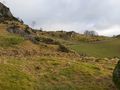
Image:2023-02-24_58_6_Pica42_1677230763013.jpg|Solberg [https://openstreetmap.org/?mlat=58.59485420&mlon=6.04269600&zoom=16 @58.5949,6.0427] | Image:2023-02-24_58_6_Pica42_1677230763013.jpg|Solberg [https://openstreetmap.org/?mlat=58.59485420&mlon=6.04269600&zoom=16 @58.5949,6.0427] | ||
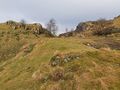
| + | Image:20230224 58 6-NE.jpg|thumb|View to the northeast. | ||
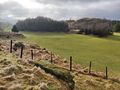
| + | Image:20230224 58 6-NW.jpg|thumb|View to the northwest. | ||
| + | Image:20230224 58 6-SE.jpg|thumb|View to the southeast. | ||
</gallery> | </gallery> | ||
| Line 41: | Line 54: | ||
<!-- Add any achievement ribbons you earned below, or remove this section --> | <!-- Add any achievement ribbons you earned below, or remove this section --> | ||
| − | + | {{land geohash |name=[[User:Pica42|Pica42]] |date=2023-02-24 |latitude=58 |longitude=6 }} | |
| − | |||
| − | |||
| − | [[ | ||
| − | |||
| − | |||
| − | |||
| − | |||
| − | |||
| − | |||
| − | |||
| − | |||
| − | |||
| − | |||
| − | |||
[[Category:Expeditions]] | [[Category:Expeditions]] | ||
| − | |||
[[Category:Expeditions with photos]] | [[Category:Expeditions with photos]] | ||
| − | |||
| − | |||
| − | |||
| − | |||
| − | |||
[[Category:Coordinates reached]] | [[Category:Coordinates reached]] | ||
| + | {{location|NO|11}} | ||
| − | + | __NOTOC__ | |
| − | |||
| − | |||
| − | |||
| − | |||
| − | |||
| − | |||
| − | |||
| − | |||
| − | |||
| − | |||
| − | |||
| − | |||
| − | |||
| − | |||
| − | |||
Latest revision as of 13:50, 24 February 2023
| Fri 24 Feb 2023 in 58,6: 58.5948580, 6.0426858 geohashing.info google osm bing/os kml crox |

Location
On the farm Solberg, Bjerkreim, Norway
Participants
Plans
Expedition
Today's trip was quite nice despite the fact that it was cold, it rained a little and it was quite windy. The trip from home was about 50 km each way to the farm Solberg in Bjerkreim, Norway. We stopped in the yard where we met a very nice farmer who showed us where we could park. We were also met by a Border collie who was happy to sniff me. It wasn't far to walk from the parking lot to the hash.
Tracklog
Photos

Solberg @58.5949,6.0427
View to the northeast.
View to the northwest.
View to the southeast.


Achievements
Pica42 earned the Land geohash achievement
|