Difference between revisions of "2023-03-02 58 5"
From Geohashing
(→Tracklog) |
(→Expedition) |
||
| (5 intermediate revisions by the same user not shown) | |||
| Line 26: | Line 26: | ||
== Expedition == | == Expedition == | ||
<!-- how it all turned out. your narrative goes here. --> | <!-- how it all turned out. your narrative goes here. --> | ||
| + | |||
| + | Today's hash expedition was a morning trip. First by car to Brusand, approx. 36 km. Then on foot about 800 m to the hash point. I met the farmer who owns the farm where the zero point was, apart from that nothing special happened. | ||
== Tracklog == | == Tracklog == | ||
| Line 39: | Line 41: | ||
Image:2023-03-02_58_5_Pica42_1677746093572.jpg|Brusand [https://openstreetmap.org/?mlat=58.54500520&mlon=5.77482260&zoom=16 @58.5450,5.7748] | Image:2023-03-02_58_5_Pica42_1677746093572.jpg|Brusand [https://openstreetmap.org/?mlat=58.54500520&mlon=5.77482260&zoom=16 @58.5450,5.7748] | ||
| + | Image:Screenshot 20230302-58-5 Geohash Droid.jpg|thumb|Screen | ||
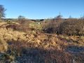
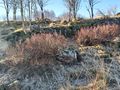
| + | Image:20230302 58-5-N.jpg|thumb|View to the north. | ||
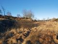
| + | Image:20230302 58-5-NW.jpg|thumb|View to the north west. | ||
| + | Image:20230302 58-5-SW.jpg|thumb|View to the south west. | ||
</gallery> | </gallery> | ||
| Line 45: | Line 51: | ||
<!-- Add any achievement ribbons you earned below, or remove this section --> | <!-- Add any achievement ribbons you earned below, or remove this section --> | ||
| − | + | {{land geohash |name=[[User:Pica42|Pica42]] |date=2023-03-02 |latitude=58 |longitude=5 }} | |
| − | |||
| − | |||
| − | [[ | ||
| − | |||
| − | |||
| − | |||
| − | |||
| − | |||
| − | |||
| − | |||
| − | |||
| − | |||
| − | |||
| − | |||
[[Category:Expeditions]] | [[Category:Expeditions]] | ||
| − | |||
[[Category:Expeditions with photos]] | [[Category:Expeditions with photos]] | ||
| − | |||
| − | |||
| − | |||
| − | |||
| − | |||
[[Category:Coordinates reached]] | [[Category:Coordinates reached]] | ||
| + | {{location|NO|11}} | ||
| − | + | __NOTOC__ | |
| − | |||
| − | |||
| − | |||
| − | |||
| − | |||
| − | |||
| − | |||
| − | |||
| − | |||
| − | |||
| − | |||
| − | |||
| − | |||
| − | |||
| − | |||
| − | |||
Latest revision as of 11:01, 2 March 2023
| Thu 2 Mar 2023 in 58,5: 58.5450205, 5.7747877 geohashing.info google osm bing/os kml crox |
Location
On the farm Hellevollen, Brusand, Hå, Norway
Participants
Plans
Expedition
Today's hash expedition was a morning trip. First by car to Brusand, approx. 36 km. Then on foot about 800 m to the hash point. I met the farmer who owns the farm where the zero point was, apart from that nothing special happened.
Tracklog
Photos

Brusand @58.5450,5.7748

Screen
View to the north.
View to the north west.
View to the south west.


Achievements
Pica42 earned the Land geohash achievement
|