Difference between revisions of "2023-05-04 41 -88"
m (Remove gennyble from the first expedition section) |
m (Location) |
||
| (3 intermediate revisions by 2 users not shown) | |||
| Line 8: | Line 8: | ||
== Participants == | == Participants == | ||
| − | [[User:Tarasaurus|Tarasaurus]] | + | * [[User:Tarasaurus|Tarasaurus]] |
| + | * [[User:Gennyble|gennyble]] | ||
== Plans == | == Plans == | ||
| Line 14: | Line 15: | ||
== Expedition == | == Expedition == | ||
| − | + | ===Expedition Tarasaurus=== | |
| + | It's wonderful on those rare occasions that a geohash lines up perfectly with plans that had already been made. In the middle of my 3 days off from work this week, I intended to get outside and enjoy the nice weather with a bike ride. It had been years since I did a ride of more than a dozen miles or so, but when I saw this point was directly adjacent to a trail and I could take bicycle trails nearly the entire way I knew exactly where my ride was going to go. | ||
| − | + | I set off around noon-ish for the Fox River trails. These would lead me to the Illinois Prairie Path, and then on to the trails at the Herrick Lake and Danada forest preserves. I've driven past these areas many times and was always curious about them so it was great to get to ride through and see them for myself. They are absolutely beautiful, with the crushed gravel trail winding through forests and prairies for miles. The weather was beautiful too, bright and sunny and a perfectly comfortable temperature for a long bike ride. | |
| − | |||
| − | + | I arrived near the hash around 90 minutes after setting off, and followed the now grass trail a short distance to the north. The actual hash point was a short distance into the prairie grass which fortunately hasn't grown very tall just yet. After getting the obligatory proof and some photos, I rested for a bit in the shade of a nearby tree before setting off for home. My legs were totally spent by the time I made it back but it made for a wonderful evening getting to lay around and rest. 10/10, would bike through those nature areas again. | |
| − | |||
| − | |||
| − | |||
| − | |||
| − | |||
| − | == Expedition gennyble == | + | === Expedition gennyble === |
The point laid in the Danada Forest Preserve, which was exciting to me! I'd been casually looking at the geohash points for a few months and this was the first one that felt close enough to go for ''and'' I had time to try and get it. | The point laid in the Danada Forest Preserve, which was exciting to me! I'd been casually looking at the geohash points for a few months and this was the first one that felt close enough to go for ''and'' I had time to try and get it. | ||
| Line 32: | Line 28: | ||
== Photos == | == Photos == | ||
| + | ===Tarasaurus=== | ||
<gallery perrow="5"> | <gallery perrow="5"> | ||
| − | Image:skunkhat_quarter.jpg|Favourite | + | Image:2023-05-04 41 -88 map.jpg|Map of the local bike trails |
| + | Image:2023-05-04 48 -88 bike.jpg|The ride through the preserves was beautiful | ||
| + | Image:2023-05-04 41 -88 lake.jpg|Herrick Lake was beautiful as well | ||
| + | Image:2023-05-04 41 -88 bike2.jpg|Trusty bike getting some rest | ||
| + | Image:2023-05-04 41 -88 hash.jpg|The hash was just inside this prairie | ||
| + | Image:2023-05-04 41 -88 grin.jpg|Sylvie and I at the hash point | ||
| + | Image:2023-05-04 41 -88 tara proof.jpg|Geohash droid proof | ||
| + | </gallery> | ||
| + | ===Gennyble=== | ||
| + | <gallery perrow="5"> | ||
| + | Image:skunkhat_quarter.jpg|Favourite hat at the point | ||
Image:Gennyble_proof_2023-05-04.jpg|Geohash Droid proof | Image:Gennyble_proof_2023-05-04.jpg|Geohash Droid proof | ||
</gallery> | </gallery> | ||
| Line 39: | Line 46: | ||
== Achievements == | == Achievements == | ||
{{#vardefine:ribbonwidth|100%}} | {{#vardefine:ribbonwidth|100%}} | ||
| − | + | {{land geohash | |
| − | + | | latitude = 41 | |
| − | + | | longitude = -88 | |
| − | + | | date = 2023-05-04 | |
| − | + | | name = Gennyble | |
| − | + | }} | |
| − | + | {{land geohash | |
| − | + | | latitude = 41 | |
| − | + | | longitude = -88 | |
| − | + | | date = 2023-05-04 | |
| − | + | | name = Tarasaurus | |
| − | + | }} | |
| − | -- | + | {{bicycle geohash |
| − | + | | latitude = 41 | |
| − | + | | longitude = -88 | |
| − | + | | date = 2023-05-04 | |
| − | + | | name = Tarasaurus | |
| + | | distance = 36 miles (58km) | ||
| + | | bothways = true (optional) | ||
| + | }} | ||
[[Category:Expeditions]] | [[Category:Expeditions]] | ||
| − | |||
[[Category:Expeditions with photos]] | [[Category:Expeditions with photos]] | ||
| − | |||
| − | |||
| − | |||
| − | |||
| − | |||
[[Category:Coordinates reached]] | [[Category:Coordinates reached]] | ||
| − | + | {{location|US|IL|DU}} | |
| − | |||
| − | |||
| − | |||
| − | |||
| − | |||
| − | |||
| − | |||
| − | |||
| − | |||
| − | |||
| − | |||
| − | |||
| − | |||
| − | |||
| − | |||
| − | |||
| − | |||
Revision as of 12:42, 5 May 2023
| Thu 4 May 2023 in 41,-88: 41.8220664, -88.1107722 geohashing.info google osm bing/os kml crox |
Contents
Location
Along side a trail in the Danada Forest Preserve near Warrenville.
Participants
Plans
Ride my bicycle over there around noon - Tara
Expedition
Expedition Tarasaurus
It's wonderful on those rare occasions that a geohash lines up perfectly with plans that had already been made. In the middle of my 3 days off from work this week, I intended to get outside and enjoy the nice weather with a bike ride. It had been years since I did a ride of more than a dozen miles or so, but when I saw this point was directly adjacent to a trail and I could take bicycle trails nearly the entire way I knew exactly where my ride was going to go.
I set off around noon-ish for the Fox River trails. These would lead me to the Illinois Prairie Path, and then on to the trails at the Herrick Lake and Danada forest preserves. I've driven past these areas many times and was always curious about them so it was great to get to ride through and see them for myself. They are absolutely beautiful, with the crushed gravel trail winding through forests and prairies for miles. The weather was beautiful too, bright and sunny and a perfectly comfortable temperature for a long bike ride.
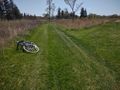
I arrived near the hash around 90 minutes after setting off, and followed the now grass trail a short distance to the north. The actual hash point was a short distance into the prairie grass which fortunately hasn't grown very tall just yet. After getting the obligatory proof and some photos, I rested for a bit in the shade of a nearby tree before setting off for home. My legs were totally spent by the time I made it back but it made for a wonderful evening getting to lay around and rest. 10/10, would bike through those nature areas again.
Expedition gennyble
The point laid in the Danada Forest Preserve, which was exciting to me! I'd been casually looking at the geohash points for a few months and this was the first one that felt close enough to go for and I had time to try and get it.
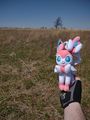
I set off around 5:30pm and arrived half an hour later, getting gas on the way. I walked the trail to the point, took a photo of my favourite hat in the quite beautiful what-looked-to-be-prairie and headed back. One day I'd like to walk to a point, but the easy route (via car) was alright for my first recorded hash.
Photos
Tarasaurus
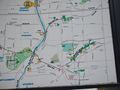
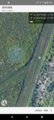
Map of the local bike trails
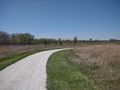
The ride through the preserves was beautiful
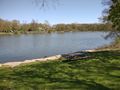
Herrick Lake was beautiful as well
Trusty bike getting some rest
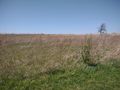
The hash was just inside this prairie
Sylvie and I at the hash point
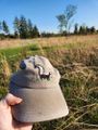
Geohash droid proof


Gennyble
Favourite hat at the point

Geohash Droid proof


Achievements
Gennyble earned the Land geohash achievement
|
Tarasaurus earned the Land geohash achievement
|
Tarasaurus earned the Bicycle geohash achievement
|