Difference between revisions of "2023-05-09 45 -122"
From Geohashing
Michael5000 (talk | contribs) |
Michael5000 (talk | contribs) (→Photos) |
||
| Line 16: | Line 16: | ||
<gallery perrow="5"> | <gallery perrow="5"> | ||
| − | File:2023-05-09 45 -122 1.jpg | + | File:2023-05-09 45 -122 1.jpg|Bicycle destinations in SW Washington |
| − | File:2023-05-09 45 -122 2.jpg | + | File:2023-05-09 45 -122 2.jpg|The hashpoint is at the nearest tree |
| − | File:2023-05-09 45 -122 5.jpg | + | File:2023-05-09 45 -122 5.jpg|I was there! |
| − | File:2023-05-09 45 -122 3.jpg | + | File:2023-05-09 45 -122 3.jpg|Returning on the I-205 bike path |
| − | File:2023-05-09 45 -122 4.jpg | + | File:2023-05-09 45 -122 4.jpg|The hashcot always enjoys a state line |
</gallery> | </gallery> | ||
Revision as of 14:01, 10 May 2023
| Tue 9 May 2023 in 45,-122: 45.6070553, -122.5572263 geohashing.info google osm bing/os kml crox |
Location
A residential street near the I-205/WA-14 interchange in southeast Vancouver.
Participants
Expedition
After work I rode my bike up to the Columbia River, followed the bike path east past the airport (and past 2023-04-23 45 -122, and then turned north again over the long, charmless, and extremely loud bike path of the Glen Jackson Bridge. The hashpoint itself was on a quiet suburban street, all very nice but not much to see, so I started back to get home before dark. The whole trip was 26.6 miles, which I think is as far as I've ever gone for a purely bicycling expedition.
Photos
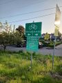
Bicycle destinations in SW Washington
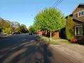
The hashpoint is at the nearest tree
I was there!
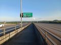
Returning on the I-205 bike path
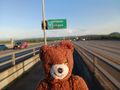
The hashcot always enjoys a state line


Achievements