Difference between revisions of "2023-07-26 62 30"
(Created page with "{{subst:expedition}}") |
m (Location) |
||
| (One intermediate revision by one other user not shown) | |||
| Line 1: | Line 1: | ||
| − | + | {{meetup graticule | |
| − | |||
| − | |||
| − | |||
| − | |||
| − | |||
| − | |||
| − | |||
| − | |||
| lat={{#explode:{{SUBPAGENAME}}| |1}} | | lat={{#explode:{{SUBPAGENAME}}| |1}} | ||
| lon={{#explode:{{SUBPAGENAME}}| |2}} | | lon={{#explode:{{SUBPAGENAME}}| |2}} | ||
| date={{#explode:{{SUBPAGENAME}}| |0}} | | date={{#explode:{{SUBPAGENAME}}| |0}} | ||
| − | }} | + | }} |
== Location == | == Location == | ||
| − | + | In Palokangas forest near Uramo lake, next to the municipal border. | |
| + | |||
| + | The point on a topographic map: {{MapSiteLink | lat = 62.6515817 | lon = 30.2795010 | title = Geohash+2023-07-26+62+30}} | ||
| + | (The site may glitch and throw you in a wrong place, but you can zoom out until you see the marker) | ||
== Participants == | == Participants == | ||
| − | + | * [[User:Kripakko|Kripakko]] | |
| − | + | * Kripakko's girlfriend | |
| − | == | + | == Expedition == |
| − | + | We were in Joensuu on summer holiday, and we had a rental car to use. | |
| + | This hashpoint happened to be pretty easily accessible, and the weather was good, so we went adventuring. | ||
| + | The area is nearly uninhabited as people tend to live near waterways and on hills, but there are many small forest roads, so getting there is not too difficult. | ||
| − | + | We parked the car on an opening by the forest road and continued on foot through the woods. | |
| − | + | Girlfriend found lots of bilberries near the top of the hill and stayed to pick them while I continued to visit the hashpoint. | |
| + | I also ate handfuls of bilberries which dyed my fingers and my mouth bright purple. | ||
| − | + | We then drove to another place where we knew we would find more bilberries. | |
| − | + | The summer has been suboptimal for wild berry pollination, and berry yield is expected to be below average, but we were still able to find nice amounts in the time we spent outside. | |
== Photos == | == Photos == | ||
| − | < | + | <gallery perrow="8"> |
| − | + | 2023-07-26_62_30_01-car.jpg | Where we parked the car, about 380 metres to go. We came along the road from the left and continued to the forest behind the car. | |
| − | -- | + | 2023-07-26_62_30_02-strawberry.jpg | Wild strawberries (''Fragaria vesca''). |
| − | + | 2023-07-26_62_30_03-bilberry.jpg | Bilberries (''Vaccinium myrtillus''). | |
| + | 2023-07-26_62_30_04-lingonberry.jpg | Lingonberries (''Vaccinium vitis-idaea''), not yet ripe. | ||
| + | 2023-07-26_62_30_05-hashpoint.jpg | How the hashpoint looked like. | ||
| + | 2023-07-26_62_30_06-gpsr1.jpg | Proof of location. | ||
| + | 2023-07-26_62_30_07-gpsr2.jpg | Proof of date and time. | ||
| + | 2023-07-26_62_30_08-selfie.jpg | Stupid Grin™ at the hashpoint. | ||
</gallery> | </gallery> | ||
== Achievements == | == Achievements == | ||
| − | {{# | + | {{land geohash |
| − | + | | name = [[User:Kripakko|Kripakko]] | |
| + | | latitude = {{#explode:{{SUBPAGENAME}}| |1}} | longitude = {{#explode:{{SUBPAGENAME}}| |2}} | date = {{#explode:{{SUBPAGENAME}}| |0}} | ||
| + | }} | ||
__NOTOC__ | __NOTOC__ | ||
| − | |||
| − | |||
| − | |||
| − | |||
| − | |||
| − | |||
| − | |||
| − | |||
| − | |||
| − | |||
| − | |||
| − | |||
| − | |||
[[Category:Expeditions]] | [[Category:Expeditions]] | ||
| − | |||
[[Category:Expeditions with photos]] | [[Category:Expeditions with photos]] | ||
| − | |||
| − | |||
| − | |||
| − | |||
| − | |||
[[Category:Coordinates reached]] | [[Category:Coordinates reached]] | ||
| − | + | {{location|FI|13}} | |
| − | |||
| − | |||
| − | |||
| − | |||
| − | |||
| − | |||
| − | |||
| − | |||
| − | |||
| − | |||
| − | |||
| − | |||
| − | |||
| − | |||
| − | |||
| − | |||
| − | |||
Revision as of 17:42, 28 July 2023
| Wed 26 Jul 2023 in 62,30: 62.6515817, 30.2795010 geohashing.info google osm bing/os kml crox |
Location
In Palokangas forest near Uramo lake, next to the municipal border.
The point on a topographic map: [1] (The site may glitch and throw you in a wrong place, but you can zoom out until you see the marker)
Participants
- Kripakko
- Kripakko's girlfriend
Expedition
We were in Joensuu on summer holiday, and we had a rental car to use. This hashpoint happened to be pretty easily accessible, and the weather was good, so we went adventuring. The area is nearly uninhabited as people tend to live near waterways and on hills, but there are many small forest roads, so getting there is not too difficult.
We parked the car on an opening by the forest road and continued on foot through the woods. Girlfriend found lots of bilberries near the top of the hill and stayed to pick them while I continued to visit the hashpoint. I also ate handfuls of bilberries which dyed my fingers and my mouth bright purple.
We then drove to another place where we knew we would find more bilberries. The summer has been suboptimal for wild berry pollination, and berry yield is expected to be below average, but we were still able to find nice amounts in the time we spent outside.
Photos
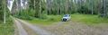
Where we parked the car, about 380 metres to go. We came along the road from the left and continued to the forest behind the car.
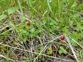
Wild strawberries (Fragaria vesca).
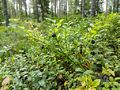
Bilberries (Vaccinium myrtillus).
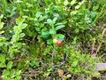
Lingonberries (Vaccinium vitis-idaea), not yet ripe.
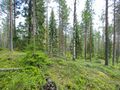
How the hashpoint looked like.
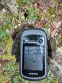
Proof of location.
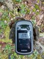
Proof of date and time.
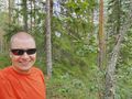
Stupid Grin™ at the hashpoint.


Achievements
Kripakko earned the Land geohash achievement
|