Difference between revisions of "2023-07-17 -23 -46"
([live picture]Nice church nearby [https://openstreetmap.org/?mlat=-23.58573590&mlon=-46.72156290&zoom=16 @-23.5857,-46.7216]) |
m (Location) |
||
| (7 intermediate revisions by 2 users not shown) | |||
| Line 14: | Line 14: | ||
== Location == | == Location == | ||
<!-- where you've surveyed the hash to be --> | <!-- where you've surveyed the hash to be --> | ||
| + | A large avenue in the west side of the city, within 400 meters of a subway station. | ||
== Participants == | == Participants == | ||
<!-- who attended: If you link to your wiki user name in this section, your expedition will be picked up by the various statistics generated for geohashing. You may use three tildes ~ as a shortcut to automatically insert the user signature of the account you are editing with. | <!-- who attended: If you link to your wiki user name in this section, your expedition will be picked up by the various statistics generated for geohashing. You may use three tildes ~ as a shortcut to automatically insert the user signature of the account you are editing with. | ||
--> | --> | ||
| + | [[User:Shugyosha|Shugyosha]] ([[User talk:Shugyosha|talk]]) | ||
== Plans == | == Plans == | ||
<!-- what were the original plans --> | <!-- what were the original plans --> | ||
| + | Since the end of my "working at home" stint, I haven't had much free time to consider visiting hashes. But I still try to check locations, and today's happened to be three blocks from a subway station on the line I use to and from work. I was already at work when that was calculated (timezones are not friendly for geohashing in Brasil), but I decided to try and go there on my way home. | ||
== Expedition == | == Expedition == | ||
<!-- how it all turned out. your narrative goes here. --> | <!-- how it all turned out. your narrative goes here. --> | ||
| + | Quite uneventful. Left work a little earlier than usual, took the subway on the opposite direction I'd usually go. Less than five minutes walk to the hash. It had seemed to be on the sidewalk, but upon arrival the GPS couldn't get a fix. Not much to do at the site at that hour, so I just went back to the subway and home. | ||
== Tracklog == | == Tracklog == | ||
| Line 36: | Line 40: | ||
Image:2023-07-17_-23_-46_shugyosha_1689628642702.jpg|Not a very remarkable location [https://openstreetmap.org/?mlat=-23.58537010&mlon=-46.72066030&zoom=16 @-23.5854,-46.7207] | Image:2023-07-17_-23_-46_shugyosha_1689628642702.jpg|Not a very remarkable location [https://openstreetmap.org/?mlat=-23.58537010&mlon=-46.72066030&zoom=16 @-23.5854,-46.7207] | ||
| − | Image:2023-07-17_-23_- | + | Image:2023-07-17_-23_-46_shugyosha_1689629389807.jpg|But a nice church nearby [https://openstreetmap.org/?mlat=-23.58573590&mlon=-46.72156290&zoom=16 @-23.5857,-46.7216] |
| − | Image:2023-07-17_-23_- | + | Image:2023-07-17_-23_-46_shugyosha_1689636385257.jpg|Screen grab. GPS reading kept jumping |
</gallery> | </gallery> | ||
| Line 46: | Line 50: | ||
__NOTOC__ | __NOTOC__ | ||
| − | |||
| − | |||
| − | |||
| − | |||
| − | |||
| − | |||
| − | |||
| − | |||
| − | |||
| − | |||
| − | |||
| − | |||
| − | |||
| − | |||
[[Category:Expeditions]] | [[Category:Expeditions]] | ||
| − | |||
[[Category:Expeditions with photos]] | [[Category:Expeditions with photos]] | ||
| − | |||
| − | |||
| − | |||
| − | |||
| − | |||
[[Category:Coordinates reached]] | [[Category:Coordinates reached]] | ||
| − | + | {{location|BR|SP}} | |
| − | |||
| − | |||
| − | |||
| − | |||
| − | |||
| − | |||
| − | |||
| − | |||
| − | |||
| − | |||
| − | |||
| − | |||
| − | |||
| − | |||
| − | |||
| − | |||
| − | |||
Latest revision as of 14:42, 30 July 2023
| Mon 17 Jul 2023 in -23,-46: -23.5852774, -46.7206362 geohashing.info google osm bing/os kml crox |
Location
A large avenue in the west side of the city, within 400 meters of a subway station.
Participants
Plans
Since the end of my "working at home" stint, I haven't had much free time to consider visiting hashes. But I still try to check locations, and today's happened to be three blocks from a subway station on the line I use to and from work. I was already at work when that was calculated (timezones are not friendly for geohashing in Brasil), but I decided to try and go there on my way home.
Expedition
Quite uneventful. Left work a little earlier than usual, took the subway on the opposite direction I'd usually go. Less than five minutes walk to the hash. It had seemed to be on the sidewalk, but upon arrival the GPS couldn't get a fix. Not much to do at the site at that hour, so I just went back to the subway and home.
Tracklog
Photos
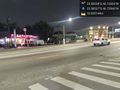
Not a very remarkable location @-23.5854,-46.7207
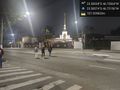
But a nice church nearby @-23.5857,-46.7216
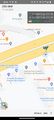
Screen grab. GPS reading kept jumping


