Difference between revisions of "2023-07-30 44 -123"
Michael5000 (talk | contribs) (→Location) |
Michael5000 (talk | contribs) (→Expedition) |
||
| (3 intermediate revisions by 2 users not shown) | |||
| Line 17: | Line 17: | ||
== Participants == | == Participants == | ||
| − | + | ||
| − | + | *[[user:Michael5000|Michael5000]] | |
| + | *[[user:Mrs.5000|Mrs.5000]] | ||
== Plans == | == Plans == | ||
| − | + | ||
| + | The original plan was to return from Hometown to Portland yesterday, on July 29th. | ||
== Expedition == | == Expedition == | ||
| − | |||
| − | + | Saturday got away from us and I was tired, so we decided to stay over another night with my parents in Hometown. That made this hashpoint, which hadn't seemed especially interesting at first glance, suddenly much more attractive. | |
| − | + | ||
| + | The Siletz Highway, Oregon 229, isn't on the way from anywhere to anywhere else, and I had only ever driven down it once before. But that's what hashpoints are for, right? We turned inland at Newport and then north at Toledo, passing through the little community of Siletz. After that point, the highway narrows and follows the Siletz River's winding course northward until it finally gives up, turns west, and heads towards the ocean. | ||
| + | |||
| + | We couldn't tell whether Strome County Park and the Barbara and Walter Brown Memorial Campground were the same thing or two different entities, but it doesn't matter much. We parked in the parking lot -- as you would expect -- and followed a trail roughly towards the hashpoint. That brought us to the campground area, which was closed and a little abandoned-looking. From there, it looked like our hashpoint would be across an impassible swamp, but it turned out to be perfectly passable lush grass instead. That brought us to an open forest, where another few hundred meters of wandering around got us to a quiet, mossy hashpoint. Easy! | ||
| + | |||
| + | We retraced our steps, continued north on Highway 229 back to US 101, and continued on towards Portland and home. | ||
== Photos == | == Photos == | ||
| − | + | ||
| − | |||
| − | |||
<gallery perrow="5"> | <gallery perrow="5"> | ||
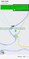
| + | File:2023-07-30 44 -123 g.jpg|A helpful map of the environs (hashpoint not marked) | ||
| + | File:2023-07-30 44 -123 f.jpg|The closed camping area | ||
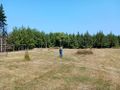
| + | File:2023-07-30 44 -123 i.jpg|Michael braves the perfectly passable lush grass | ||
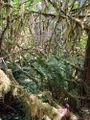
| + | File:2023-07-30 44 -123 e.jpg|Forest paths... | ||
| + | File:2023-07-30 44 -123 h.jpg|We arrive! | ||
| + | File:2023-07-30 44 -123 a.jpg|Victory photo | ||
| + | File:2023-07-30 44 -123 b.jpg|View of moss from hashpoint | ||
| + | File:2023-07-30 44 -123 d.jpg|Another view of moss from hashpoint | ||
| + | File:2023-07-30 44 -123 c.jpg|A whole panorama of moss from hashpoint | ||
</gallery> | </gallery> | ||
| Line 41: | Line 54: | ||
__NOTOC__ | __NOTOC__ | ||
| − | |||
| − | |||
| − | |||
| − | |||
| − | |||
| − | |||
| − | |||
| − | |||
| − | |||
| − | |||
| − | |||
| − | |||
| − | |||
| − | |||
[[Category:Expeditions]] | [[Category:Expeditions]] | ||
| − | |||
[[Category:Expeditions with photos]] | [[Category:Expeditions with photos]] | ||
| − | |||
| − | |||
| − | |||
| − | |||
| − | |||
[[Category:Coordinates reached]] | [[Category:Coordinates reached]] | ||
| − | + | {{location|US|OR|LC}} | |
| − | |||
| − | |||
| − | |||
| − | |||
| − | |||
| − | |||
| − | |||
| − | |||
| − | |||
| − | |||
| − | |||
| − | |||
| − | |||
| − | |||
| − | |||
| − | |||
| − | |||
Revision as of 03:58, 31 July 2023
| Sun 30 Jul 2023 in 44,-123: 44.8176492, -123.9737149 geohashing.info google osm bing/os kml crox |
Location
In a Lincoln County Park off the Siletz Highway.
Participants
Plans
The original plan was to return from Hometown to Portland yesterday, on July 29th.
Expedition
Saturday got away from us and I was tired, so we decided to stay over another night with my parents in Hometown. That made this hashpoint, which hadn't seemed especially interesting at first glance, suddenly much more attractive.
The Siletz Highway, Oregon 229, isn't on the way from anywhere to anywhere else, and I had only ever driven down it once before. But that's what hashpoints are for, right? We turned inland at Newport and then north at Toledo, passing through the little community of Siletz. After that point, the highway narrows and follows the Siletz River's winding course northward until it finally gives up, turns west, and heads towards the ocean.
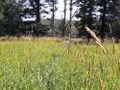
We couldn't tell whether Strome County Park and the Barbara and Walter Brown Memorial Campground were the same thing or two different entities, but it doesn't matter much. We parked in the parking lot -- as you would expect -- and followed a trail roughly towards the hashpoint. That brought us to the campground area, which was closed and a little abandoned-looking. From there, it looked like our hashpoint would be across an impassible swamp, but it turned out to be perfectly passable lush grass instead. That brought us to an open forest, where another few hundred meters of wandering around got us to a quiet, mossy hashpoint. Easy!
We retraced our steps, continued north on Highway 229 back to US 101, and continued on towards Portland and home.
Photos
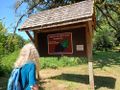
A helpful map of the environs (hashpoint not marked)
The closed camping area
Michael braves the perfectly passable lush grass
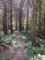
Forest paths...
We arrive!

Victory photo
View of moss from hashpoint
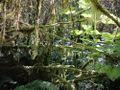
Another view of moss from hashpoint

A whole panorama of moss from hashpoint


