Difference between revisions of "2023-08-03 58 5"
From Geohashing
(→Photos) |
(→Achievements) |
||
| Line 54: | Line 54: | ||
<!-- Add any achievement ribbons you earned below, or remove this section --> | <!-- Add any achievement ribbons you earned below, or remove this section --> | ||
| − | + | {{land geohash |name=[[User:Pica42|Pica42]] |date=2023-087-03 |latitude=58 |longitude=5 }} | |
| − | |||
| − | |||
| − | [[ | ||
| − | |||
| − | |||
| − | |||
| − | |||
| − | |||
| − | |||
| − | |||
| − | |||
| − | |||
| − | |||
| − | |||
[[Category:Expeditions]] | [[Category:Expeditions]] | ||
| − | |||
[[Category:Expeditions with photos]] | [[Category:Expeditions with photos]] | ||
| − | |||
| − | |||
| − | |||
| − | |||
| − | |||
[[Category:Coordinates reached]] | [[Category:Coordinates reached]] | ||
| + | {{location|NO|11}} | ||
| − | + | __NOTOC__ | |
| − | |||
| − | |||
| − | |||
| − | |||
| − | |||
| − | |||
| − | |||
| − | |||
| − | |||
| − | |||
| − | |||
| − | |||
| − | |||
| − | |||
| − | |||
| − | |||
Revision as of 14:21, 3 August 2023
| Thu 3 Aug 2023 in 58,5: 58.7483404, 5.8626202 geohashing.info google osm bing/os kml crox |

Location
A short distance above an old dam called Stemmen and located near Ålgård, Gjesdal, Norway
Participants
Plans
Expedition
Tracklog
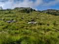
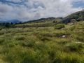
Photos

Stemmen @58.7484,5.8627
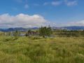
View to the northeast
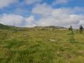
View to the northwest
View to the southwest
View to the southeast
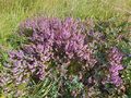
Røsslyng near the Hash point
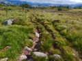
The path down from the hash point
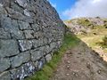
The old dam I passed on the way up and down


Achievements
Pica42 earned the Land geohash achievement
|