Difference between revisions of "2023-08-03 58 5"
(An expedition message sent via Geohash Droid for Android.) |
(→Location) |
||
| (19 intermediate revisions by the same user not shown) | |||
| Line 12: | Line 12: | ||
| date=2023-08-03 | | date=2023-08-03 | ||
}}<!-- edit as necessary --> | }}<!-- edit as necessary --> | ||
| + | [[Image:20230803 110151.jpg|thumb|left]] | ||
== Location == | == Location == | ||
<!-- where you've surveyed the hash to be --> | <!-- where you've surveyed the hash to be --> | ||
| + | |||
| + | A short distance above an old dam called Stemmen, located near Ålgård, Gjesdal, Norway | ||
== Participants == | == Participants == | ||
<!-- who attended: If you link to your wiki user name in this section, your expedition will be picked up by the various statistics generated for geohashing. You may use three tildes ~ as a shortcut to automatically insert the user signature of the account you are editing with. | <!-- who attended: If you link to your wiki user name in this section, your expedition will be picked up by the various statistics generated for geohashing. You may use three tildes ~ as a shortcut to automatically insert the user signature of the account you are editing with. | ||
--> | --> | ||
| + | |||
| + | *[[User:Pica42|Pica42]] | ||
== Plans == | == Plans == | ||
| Line 24: | Line 29: | ||
== Expedition == | == Expedition == | ||
<!-- how it all turned out. your narrative goes here. --> | <!-- how it all turned out. your narrative goes here. --> | ||
| + | |||
| + | Today's trip was quite a nice trip. On my way to the geohash, I passed many roller skiers who were preparing for a competition later in the day. From the parking lot to the geohash it was just over a km uphill, so I was pretty sweaty when I got up. The path up varied from good to usable. The plan was that I would also look for a couple of Geocaches since I was in the area. The first cache I came to was high up in a tree so it will have to wait until later, here I need safety equipment. I found the second cache after a few minutes of searching. A Geohash and a Geocache on the same day makes me very happy. | ||
== Tracklog == | == Tracklog == | ||
<!-- if your GPS device keeps a log, you may use Template:Tracklog, post a link here, or both --> | <!-- if your GPS device keeps a log, you may use Template:Tracklog, post a link here, or both --> | ||
| + | |||
| + | {{tracklog |activity 11703743128.gpx}} | ||
== Photos == | == Photos == | ||
| Line 33: | Line 42: | ||
--> | --> | ||
<gallery perrow="5"> | <gallery perrow="5"> | ||
| + | |||
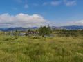
| + | Image:2023-08-03_58_5_Pica42_1691053479315.jpg|Stemmen [https://openstreetmap.org/?mlat=58.74836620&mlon=5.86265220&zoom=16 @58.7484,5.8627] | ||
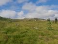
| + | Image:1691069459472 58 5 NE.jpg|thumb|View to the northeast | ||
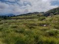
| + | Image:1691069508361 58 5 NV.jpg|thumb|View to the northwest | ||
| + | Image:1691069548260 58 5 SV.jpg|thumb|View to the southwest | ||
| + | Image:1691069583269 58 5 SE.jpg|thumb|View to the southeast | ||
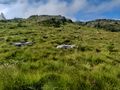
| + | Image:1691069617052 58 5 Rössling.jpg|thumb|Røsslyng near the Hash point | ||
| + | Image:1691069661549.jpg|thumb|The path down from the hash point | ||
| + | Image:1691069694561 58 5 Dam.jpg|thumb|The old dam I passed on the way up and down | ||
| + | |||
</gallery> | </gallery> | ||
| Line 39: | Line 58: | ||
<!-- Add any achievement ribbons you earned below, or remove this section --> | <!-- Add any achievement ribbons you earned below, or remove this section --> | ||
| − | + | {{land geohash |name=[[User:Pica42|Pica42]] |date=2023-08-03 |latitude=58 |longitude=5 }} | |
| − | |||
| − | |||
| − | [[ | ||
| − | |||
| − | |||
| − | |||
| − | |||
| − | |||
| − | |||
| − | |||
| − | |||
| − | |||
| − | |||
| − | |||
[[Category:Expeditions]] | [[Category:Expeditions]] | ||
| − | |||
[[Category:Expeditions with photos]] | [[Category:Expeditions with photos]] | ||
| − | |||
| − | |||
| − | |||
| − | |||
| − | |||
[[Category:Coordinates reached]] | [[Category:Coordinates reached]] | ||
| + | {{location|NO|11}} | ||
| − | + | __NOTOC__ | |
| − | |||
| − | |||
| − | |||
| − | |||
| − | |||
| − | |||
| − | |||
| − | |||
| − | |||
| − | |||
| − | |||
| − | |||
| − | |||
| − | |||
| − | |||
| − | |||
Latest revision as of 06:08, 5 August 2023
| Thu 3 Aug 2023 in 58,5: 58.7483404, 5.8626202 geohashing.info google osm bing/os kml crox |

Location
A short distance above an old dam called Stemmen, located near Ålgård, Gjesdal, Norway
Participants
Plans
Expedition
Today's trip was quite a nice trip. On my way to the geohash, I passed many roller skiers who were preparing for a competition later in the day. From the parking lot to the geohash it was just over a km uphill, so I was pretty sweaty when I got up. The path up varied from good to usable. The plan was that I would also look for a couple of Geocaches since I was in the area. The first cache I came to was high up in a tree so it will have to wait until later, here I need safety equipment. I found the second cache after a few minutes of searching. A Geohash and a Geocache on the same day makes me very happy.
Tracklog
Photos

Stemmen @58.7484,5.8627
View to the northeast
View to the northwest
View to the southwest
View to the southeast
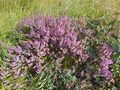
Røsslyng near the Hash point
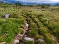
The path down from the hash point
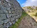
The old dam I passed on the way up and down


Achievements
Pica42 earned the Land geohash achievement
|