Difference between revisions of "2023-09-11 58 5"
From Geohashing
([live picture]Krågedal [https://openstreetmap.org/?mlat=58.83969760&mlon=5.91401270&zoom=16 @58.8397,5.9140]) |
([live picture]Kråkedal) |
||
| Line 48: | Line 48: | ||
Image:2023-09-11_58_5_Pica42_1694436874506.jpg|Krågedal [https://openstreetmap.org/?mlat=58.83969760&mlon=5.91401270&zoom=16 @58.8397,5.9140] | Image:2023-09-11_58_5_Pica42_1694436874506.jpg|Krågedal [https://openstreetmap.org/?mlat=58.83969760&mlon=5.91401270&zoom=16 @58.8397,5.9140] | ||
| + | |||
| + | Image:2023-09-11_58_5_Pica42_1694436874511.jpg|Kråkedal | ||
</gallery> | </gallery> | ||
Revision as of 12:54, 11 September 2023
| Mon 11 Sep 2023 in 58,5: 58.8396917, 5.9140773 geohashing.info google osm bing/os kml crox |

Location
On a slope at Kråkedal, Sandnes, Norway
Participants
Plans
Expedition
Tracklog
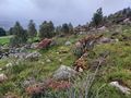
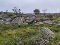
Photos
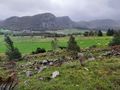
View to the east
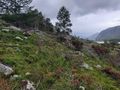
View to the south
View to the west
View to the north
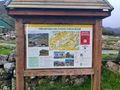
Information sign
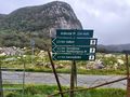
Signs showing hiking trails

Krågedal @58.8397,5.9140

Kråkedal


Achievements
Pica42 earned the Land geohash achievement
|