Difference between revisions of "2023-09-11 58 5"
From Geohashing
(→Photos) |
(→Photos) |
||
| (10 intermediate revisions by the same user not shown) | |||
| Line 32: | Line 32: | ||
== Tracklog == | == Tracklog == | ||
<!-- if your GPS device keeps a log, you may use Template:Tracklog, post a link here, or both --> | <!-- if your GPS device keeps a log, you may use Template:Tracklog, post a link here, or both --> | ||
| + | |||
| + | {{tracklog |activity_11997099036.gpx}} | ||
== Photos == | == Photos == | ||
| Line 38: | Line 40: | ||
--> | --> | ||
<gallery perrow="5"> | <gallery perrow="5"> | ||
| + | Image:2023-09-11_58_5_Pica42_1694436874506.jpg|Kråkedal [https://openstreetmap.org/?mlat=58.83969760&mlon=5.91401270&zoom=16 @58.8397,5.9140] | ||
Image:20230911 58 5 E-2.jpg|thumb|View to the east | Image:20230911 58 5 E-2.jpg|thumb|View to the east | ||
| − | + | Image:20230911 093749 S-2.jpg|thumb|View to the south | |
| − | + | Image:20230911 58 5 W-2.jpg|thumb|View to the west | |
| − | + | Image:20230911 58 5 N-2.jpg|thumb|View to the north | |
| − | + | Image:20230911 58 5 Info-2.jpg|thumb|Information sign | |
| − | + | Image:20230911 58 5 Sign-2.jpg|thumb|Signs showing hiking trails | |
</gallery> | </gallery> | ||
| Line 50: | Line 53: | ||
<!-- Add any achievement ribbons you earned below, or remove this section --> | <!-- Add any achievement ribbons you earned below, or remove this section --> | ||
| − | + | {{land geohash |name=[[User:Pica42|Pica42]] |date=2023-09-11 |latitude=58 |longitude=5 }} | |
| − | |||
| − | |||
| − | [[ | ||
| − | |||
| − | |||
| − | |||
| − | |||
| − | |||
| − | |||
| − | |||
| − | |||
| − | |||
| − | |||
| − | |||
[[Category:Expeditions]] | [[Category:Expeditions]] | ||
| − | |||
[[Category:Expeditions with photos]] | [[Category:Expeditions with photos]] | ||
| − | |||
| − | |||
| − | |||
| − | |||
| − | |||
[[Category:Coordinates reached]] | [[Category:Coordinates reached]] | ||
| + | {{location|NO|11}} | ||
| − | + | __NOTOC__ | |
| − | |||
| − | |||
| − | |||
| − | |||
| − | |||
| − | |||
| − | |||
| − | |||
| − | |||
| − | |||
| − | |||
| − | |||
| − | |||
| − | |||
| − | |||
| − | |||
Latest revision as of 12:57, 11 September 2023
| Mon 11 Sep 2023 in 58,5: 58.8396917, 5.9140773 geohashing.info google osm bing/os kml crox |

Location
On a slope at Kråkedal, Sandnes, Norway
Participants
Plans
Expedition
Tracklog
Photos

Kråkedal @58.8397,5.9140
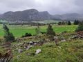
View to the east
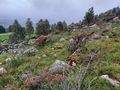
View to the south
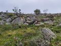
View to the west
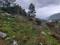
View to the north
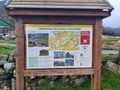
Information sign
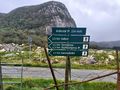
Signs showing hiking trails


Achievements
Pica42 earned the Land geohash achievement
|