Difference between revisions of "2023-09-11 58 5"
From Geohashing
(→Photos) |
(→Photos) |
||
| Line 40: | Line 40: | ||
--> | --> | ||
<gallery perrow="5"> | <gallery perrow="5"> | ||
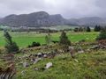
| − | Image:2023-09-11_58_5_Pica42_1694436874506.jpg| | + | Image:2023-09-11_58_5_Pica42_1694436874506.jpg|Kråkedal [https://openstreetmap.org/?mlat=58.83969760&mlon=5.91401270&zoom=16 @58.8397,5.9140] |
Image:20230911 58 5 E-2.jpg|thumb|View to the east | Image:20230911 58 5 E-2.jpg|thumb|View to the east | ||
Image:20230911 093749 S-2.jpg|thumb|View to the south | Image:20230911 093749 S-2.jpg|thumb|View to the south | ||
Latest revision as of 12:57, 11 September 2023
| Mon 11 Sep 2023 in 58,5: 58.8396917, 5.9140773 geohashing.info google osm bing/os kml crox |

Location
On a slope at Kråkedal, Sandnes, Norway
Participants
Plans
Expedition
Tracklog
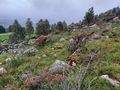
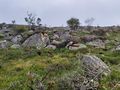
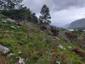
Photos

Kråkedal @58.8397,5.9140
View to the east
View to the south
View to the west
View to the north
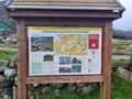
Information sign
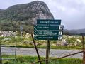
Signs showing hiking trails


Achievements
Pica42 earned the Land geohash achievement
|