Difference between revisions of "2023-09-16 41 -72"
| (11 intermediate revisions by 3 users not shown) | |||
| Line 1: | Line 1: | ||
| − | + | {{meetup graticule | |
| − | |||
| − | |||
| − | |||
| − | |||
| − | |||
| − | |||
| − | |||
| − | |||
| lat={{#explode:{{SUBPAGENAME}}| |1}} | | lat={{#explode:{{SUBPAGENAME}}| |1}} | ||
| lon={{#explode:{{SUBPAGENAME}}| |2}} | | lon={{#explode:{{SUBPAGENAME}}| |2}} | ||
| Line 13: | Line 5: | ||
}}<!-- edit as necessary --> | }}<!-- edit as necessary --> | ||
== Location == | == Location == | ||
| − | In a field in | + | In a field in North Franklin, CT. |
== Participants == | == Participants == | ||
| − | [[User:JBest]] | + | *[[User:JBest|JBest]] |
| − | + | *MapMan | |
| − | MapMan | ||
== Plans == | == Plans == | ||
| − | I was not anticipating going hashing this day as I had schoolwork | + | I was not anticipating going hashing this day as I had schoolwork as my primary focus, but then MapMan told me that he was willing to go, it wasn't too far away and I wasn't doing anything too important, so off we go! |
== Expedition == | == Expedition == | ||
| − | + | We set out on a smooth travel, easy GPS directions the way through (sorry no tracklog), with MapMan hoping to get there for the magic 4 o'clock hour. The nearest parking lot to the field was for an asphalt contractor who was closed for the weekend, so we parked across the street at what Google Maps said was a martial arts dojo, but it looked much more like a children's nursery; perhaps the dojo was on the other side of the building. I pointed out that the field seemed to belong to a property with the house to the north of it, but MapMan had a bit of a white lie ready just in case people asked what we were doing, and the house was not close enough for people to find us out easily. Nobody else was there for the magic hash-time. | |
| − | + | Crossing the street, we entered the field and made our trek to the hashpoint. We both were using Google Maps (I know, not the most precise) which led us to find a happy medium between the two spots on our phones. We then noticed that someone was coming out of the house. I quickly snapped pictures of the surrounding four cardinal directions, and then we hi-tailed out of there. The person didn't seem to notice us, they just went into their truck. | |
| − | + | ||
| + | Back across the street, I grabbed a selfie of the two of us with the direction of the hash behind us, and we got out. We went back home with KFC from Willimantic for dinner, and now I am left to my own devices and back to my schoolwork. That, and editing this wiki page. This was the first expedition we did in our home graticule, and although it was pretty short and uneventful, I was glad I got the chance to do something exciting during all of the work I am busy with. :) | ||
== Photos == | == Photos == | ||
| − | |||
| − | |||
| − | |||
<gallery perrow="5"> | <gallery perrow="5"> | ||
| + | Image:Screenshot 20230916-160600 Maps.jpg|Google Maps view from the driveway. | ||
| + | Image:20230916_160430.jpg|Where we parked... | ||
| + | Image:20230916_160636.jpg|...and where we needed to go! | ||
| + | Image:20230916_160241.jpg|Hash north view. | ||
| + | Image:20230916_160245.jpg|Hash west view. | ||
| + | Image:20230916_160237.jpg|Hash east view. | ||
| + | Image:20230916_160234.jpg|Hash south view. | ||
| + | Image:20230916_160407.jpg|Ourselves with that grin and the hash spot behind us. | ||
</gallery> | </gallery> | ||
== Achievements == | == Achievements == | ||
| − | {{ | + | {{Two to the N achievement |
| − | |||
| − | + | | count = 1 | |
| − | + | | date = 2023-09-16 | |
| − | + | | latitude = 41 | |
| − | + | | longitude = -72 | |
| + | | name = JBest | ||
| + | | reached = true (optional - include if you are counting coordinates reached) | ||
| + | }} | ||
| − | |||
| − | + | __NOTOC__ | |
| − | |||
| − | |||
| − | |||
| − | |||
| − | |||
| − | |||
| − | |||
[[Category:Expeditions]] | [[Category:Expeditions]] | ||
| − | |||
[[Category:Expeditions with photos]] | [[Category:Expeditions with photos]] | ||
| − | |||
| − | |||
| − | |||
| − | |||
| − | |||
[[Category:Coordinates reached]] | [[Category:Coordinates reached]] | ||
| − | + | {{location|US|CT|NL}} | |
| − | |||
| − | |||
| − | |||
| − | |||
| − | |||
| − | |||
| − | |||
| − | |||
| − | |||
| − | |||
| − | |||
| − | |||
| − | |||
| − | |||
| − | |||
| − | |||
| − | |||
Latest revision as of 18:46, 28 September 2023
| Sat 16 Sep 2023 in 41,-72: 41.6432949, -72.1615788 geohashing.info google osm bing/os kml crox |
Location
In a field in North Franklin, CT.
Participants
- JBest
- MapMan
Plans
I was not anticipating going hashing this day as I had schoolwork as my primary focus, but then MapMan told me that he was willing to go, it wasn't too far away and I wasn't doing anything too important, so off we go!
Expedition
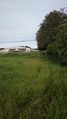
We set out on a smooth travel, easy GPS directions the way through (sorry no tracklog), with MapMan hoping to get there for the magic 4 o'clock hour. The nearest parking lot to the field was for an asphalt contractor who was closed for the weekend, so we parked across the street at what Google Maps said was a martial arts dojo, but it looked much more like a children's nursery; perhaps the dojo was on the other side of the building. I pointed out that the field seemed to belong to a property with the house to the north of it, but MapMan had a bit of a white lie ready just in case people asked what we were doing, and the house was not close enough for people to find us out easily. Nobody else was there for the magic hash-time.
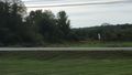
Crossing the street, we entered the field and made our trek to the hashpoint. We both were using Google Maps (I know, not the most precise) which led us to find a happy medium between the two spots on our phones. We then noticed that someone was coming out of the house. I quickly snapped pictures of the surrounding four cardinal directions, and then we hi-tailed out of there. The person didn't seem to notice us, they just went into their truck.
Back across the street, I grabbed a selfie of the two of us with the direction of the hash behind us, and we got out. We went back home with KFC from Willimantic for dinner, and now I am left to my own devices and back to my schoolwork. That, and editing this wiki page. This was the first expedition we did in our home graticule, and although it was pretty short and uneventful, I was glad I got the chance to do something exciting during all of the work I am busy with. :)
Photos
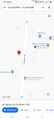
Google Maps view from the driveway.
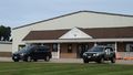
Where we parked...
...and where we needed to go!
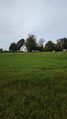
Hash north view.
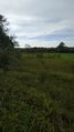
Hash west view.
Hash east view.
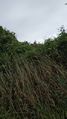
Hash south view.
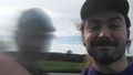
Ourselves with that grin and the hash spot behind us.


Achievements
