Difference between revisions of "2023-09-30 58 5"
From Geohashing
([live picture]Melsheia [https://openstreetmap.org/?mlat=58.82784260&mlon=5.78851860&zoom=16 @58.8278,5.7885]) |
(→Achievements) |
||
| (9 intermediate revisions by the same user not shown) | |||
| Line 12: | Line 12: | ||
| date=2023-09-30 | | date=2023-09-30 | ||
}}<!-- edit as necessary --> | }}<!-- edit as necessary --> | ||
| + | [[Image:20230930 58 5 Me.jpg|thumb|left]] | ||
== Location == | == Location == | ||
<!-- where you've surveyed the hash to be --> | <!-- where you've surveyed the hash to be --> | ||
| + | |||
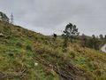
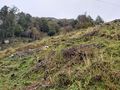
| + | On a slope northeast of Sandnes Sparebank Arena Roller Ski Track. | ||
== Participants == | == Participants == | ||
<!-- who attended: If you link to your wiki user name in this section, your expedition will be picked up by the various statistics generated for geohashing. You may use three tildes ~ as a shortcut to automatically insert the user signature of the account you are editing with. | <!-- who attended: If you link to your wiki user name in this section, your expedition will be picked up by the various statistics generated for geohashing. You may use three tildes ~ as a shortcut to automatically insert the user signature of the account you are editing with. | ||
--> | --> | ||
| + | |||
| + | *[[User:Pica42|Pica42]] | ||
== Plans == | == Plans == | ||
| Line 24: | Line 29: | ||
== Expedition == | == Expedition == | ||
<!-- how it all turned out. your narrative goes here. --> | <!-- how it all turned out. your narrative goes here. --> | ||
| + | |||
| + | Today's trip took place in gray weather with light drizzle. The hash was only about 350 meters from the car park. The ground was full of tufts and many twigs and branches. I had to walk around a bit to find a stable zero point. | ||
== Tracklog == | == Tracklog == | ||
| Line 35: | Line 42: | ||
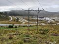
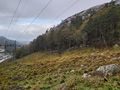
Image:2023-09-30_58_5_Pica42_1696068833117.jpg|Melsheia [https://openstreetmap.org/?mlat=58.82784260&mlon=5.78851860&zoom=16 @58.8278,5.7885] | Image:2023-09-30_58_5_Pica42_1696068833117.jpg|Melsheia [https://openstreetmap.org/?mlat=58.82784260&mlon=5.78851860&zoom=16 @58.8278,5.7885] | ||
| + | Image:20230930 58 5 SW.jpg|thumb|View to the southwest | ||
| + | Image:20230930 58 5 SE.jpg|thumb|View to the southeast | ||
| + | Image:20230930 58 5 NE.jpg|thumb|View to the northeast | ||
| + | Image:20230930 58 5 NW.jpg|thumb|View to the northwest | ||
</gallery> | </gallery> | ||
| Line 41: | Line 52: | ||
<!-- Add any achievement ribbons you earned below, or remove this section --> | <!-- Add any achievement ribbons you earned below, or remove this section --> | ||
| − | + | {{land geohash |name=[[User:Pica42|Pica42]] |date=2023-09-30 |latitude=58 |longitude=5 }} | |
| − | |||
| − | |||
| − | [[ | ||
| − | |||
| − | |||
| − | |||
| − | |||
| − | |||
| − | |||
| − | |||
| − | |||
| − | |||
| − | |||
| − | |||
[[Category:Expeditions]] | [[Category:Expeditions]] | ||
| − | |||
[[Category:Expeditions with photos]] | [[Category:Expeditions with photos]] | ||
| − | |||
| − | |||
| − | |||
| − | |||
| − | |||
[[Category:Coordinates reached]] | [[Category:Coordinates reached]] | ||
| + | {{location|NO|11}} | ||
| − | + | __NOTOC__ | |
| − | |||
| − | |||
| − | |||
| − | |||
| − | |||
| − | |||
| − | |||
| − | |||
| − | |||
| − | |||
| − | |||
| − | |||
| − | |||
| − | |||
| − | |||
| − | |||
Latest revision as of 12:05, 30 September 2023
| Sat 30 Sep 2023 in 58,5: 58.8278284, 5.7885487 geohashing.info google osm bing/os kml crox |

Location
On a slope northeast of Sandnes Sparebank Arena Roller Ski Track.
Participants
Plans
Expedition
Today's trip took place in gray weather with light drizzle. The hash was only about 350 meters from the car park. The ground was full of tufts and many twigs and branches. I had to walk around a bit to find a stable zero point.
Tracklog
Photos

Melsheia @58.8278,5.7885
View to the southwest
View to the southeast
View to the northeast
View to the northwest


Achievements
Pica42 earned the Land geohash achievement
|