Difference between revisions of "2023-10-07 43 -121"
Michael5000 (talk | contribs) (→Location) |
Michael5000 (talk | contribs) (→Photos) |
||
| (4 intermediate revisions by 2 users not shown) | |||
| Line 16: | Line 16: | ||
== Participants == | == Participants == | ||
| − | + | *[[user:Michael5000|Michael5000]] | |
| − | |||
| − | |||
| − | |||
| − | |||
== Expedition == | == Expedition == | ||
| − | + | On a business/adventuring expedition, I woke up early in Bend and (after a quick stop for a bag of bagels) headed south on US 97 for a ways, and then southwest on well-paved Century Drive for another 14 miles or so. That got me to Forest Road 4258 and then immediately to 4258-100, which was really the first opportunity for the still new expedition vehicle to show its stuff in marginal-roads geohashing. I parked within a few hundred meters of the hashpoint, and from there it was just an easy (but cold!) dawn walk through the open forest of Central Oregon. | |
| − | == | + | == Photos == |
| − | |||
| − | |||
| − | |||
| − | |||
| − | |||
<gallery perrow="5"> | <gallery perrow="5"> | ||
| + | File:2023-10-07 43 -121 a.jpg|Base Camp: Bend | ||
| + | File:2023-10-07 43 -121 b.jpg|a marginal road | ||
| + | File:2023-10-07 43 -121 c.jpg|Looking up the tree that lives at the hashpoint | ||
| + | File:2023-10-07 43 -121 d.jpg|Sunrise through the forest | ||
| + | File:2023-10-07 43 -121 e.jpg|Me | ||
| + | File:2023-10-07 43 -121 f.jpg|Finding the vehicle again | ||
| + | File:2023-10-07 43 -121 g.jpg|Yay! | ||
</gallery> | </gallery> | ||
== Achievements == | == Achievements == | ||
{{#vardefine:ribbonwidth|100%}} | {{#vardefine:ribbonwidth|100%}} | ||
| − | |||
| − | |||
| − | |||
| − | |||
| − | |||
| − | |||
| − | |||
| − | |||
| − | |||
| − | |||
| − | |||
| − | |||
| − | |||
| − | |||
| − | |||
| − | |||
| − | |||
[[Category:Expeditions]] | [[Category:Expeditions]] | ||
| − | |||
[[Category:Expeditions with photos]] | [[Category:Expeditions with photos]] | ||
| − | |||
| − | |||
| − | |||
| − | |||
| − | |||
[[Category:Coordinates reached]] | [[Category:Coordinates reached]] | ||
| − | + | *My second successful expedition to the La Pine graticule (after a 12-year lapse). | |
| − | + | *My second successful expedition to Deschutes County (after a 5-month lapse). | |
| − | + | {{location|US|OR|DE}} | |
| − | |||
| − | |||
| − | |||
| − | |||
| − | |||
| − | |||
| − | |||
| − | |||
| − | |||
| − | |||
| − | |||
| − | |||
| − | |||
| − | |||
| − | |||
Revision as of 01:50, 8 October 2023
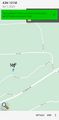
| Sat 7 Oct 2023 in 43,-121: 43.7412930, -121.6819150 geohashing.info google osm bing/os kml crox |
Location
West of La Pine in the Deschutes National Forest.
Participants
Expedition
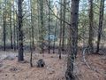
On a business/adventuring expedition, I woke up early in Bend and (after a quick stop for a bag of bagels) headed south on US 97 for a ways, and then southwest on well-paved Century Drive for another 14 miles or so. That got me to Forest Road 4258 and then immediately to 4258-100, which was really the first opportunity for the still new expedition vehicle to show its stuff in marginal-roads geohashing. I parked within a few hundred meters of the hashpoint, and from there it was just an easy (but cold!) dawn walk through the open forest of Central Oregon.
Photos

Base Camp: Bend
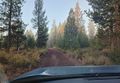
a marginal road
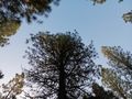
Looking up the tree that lives at the hashpoint
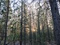
Sunrise through the forest
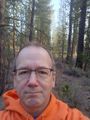
Me
Finding the vehicle again
Yay!


Achievements
- My second successful expedition to the La Pine graticule (after a 12-year lapse).
- My second successful expedition to Deschutes County (after a 5-month lapse).