Difference between revisions of "2023-10-09 37 -117"
Michael5000 (talk | contribs) (→Participants) |
Michael5000 (talk | contribs) |
||
| Line 16: | Line 16: | ||
== Participants == | == Participants == | ||
| − | [[User:Michael5000|Michael5000]] | + | [[User:Michael5000|Michael5000]] |
| − | == | + | == Expedition == |
| − | + | Waking up in Hawthorne, Nevada, this hashpoint offered an opportunity for an adventure that wouldn't add much distance to the trip to Las Vegas. Plenty of ''time'', but not much distance. | |
| − | + | From where I left pavement near the intersection of US 6 and Nevada 773 to the hashpoint, and then continuing on to the mining camp at Silver Peak, was around 38 miles of unsigned dirt road. During that drive, I saw four other vehicles, so it wasn't the most remote road on Earth by any stretch. Still, I was glad to have redundant GPS, plus a pretty good little hand-drawn map I sketched on the way in. | |
| − | |||
| − | + | The hashpoint was about a quarter mile off the road and high enough up that it felt like exercise, but it wasn't an incredibly difficult climb. The views, both from the hashpoint and all along the drive, were very striking -- it felt like some kind of live-action Minecraft scenario, with longer days and fewer monsters. | |
| − | |||
== Photos == | == Photos == | ||
<gallery perrow="5"> | <gallery perrow="5"> | ||
| − | File:2023-10-09 37 -117 a.jpg| | + | File:2023-10-09 37 -117 a.jpg|Turning left onto Nevada 773... |
| − | File:2023-10-09 37 -117 b.jpg| | + | File:2023-10-09 37 -117 b.jpg|...and then immediately onto the dirt road to the left. |
| − | File:2023-10-09 37 -117 c.jpg| | + | File:2023-10-09 37 -117 c.jpg|Driving across flats |
| − | File:2023-10-09 37 -117 d.jpg| | + | File:2023-10-09 37 -117 d.jpg|Driving up into hills |
| − | File:2023-10-09 37 -117 | + | File:2023-10-09 37 -117 j.jpg|Looking up where I'm going to climb |
| − | File:2023-10-09 37 -117 | + | File:2023-10-09 37 -117 i.jpg|Looking back down towards the vehicle |
| − | File:2023-10-09 37 -117 | + | File:2023-10-09 37 -117 e.jpg|View down from the hashpoint |
| − | File:2023-10-09 37 -117 | + | File:2023-10-09 37 -117 f.jpg|View up from the hashpoint |
| − | File:2023-10-09 37 -117 | + | File:2023-10-09 37 -117 g.jpg|My GPS, at the hashpoint |
| − | File:2023-10-09 37 -117 | + | File:2023-10-09 37 -117 h.jpg|Me, at the hashpoint |
</gallery> | </gallery> | ||
== Achievements == | == Achievements == | ||
{{#vardefine:ribbonwidth|100%}} | {{#vardefine:ribbonwidth|100%}} | ||
| − | + | {{Virgin graticule | |
| − | + | | latitude = 37 | |
| − | + | | longitude = -117 | |
| − | + | | date = 2023-10-09 | |
| − | + | | name = Michael5000 | |
| − | + | }} | |
| − | + | __NOTOC__ | |
| − | |||
| − | |||
| − | |||
| − | |||
| − | |||
| − | |||
[[Category:Expeditions]] | [[Category:Expeditions]] | ||
| − | |||
[[Category:Expeditions with photos]] | [[Category:Expeditions with photos]] | ||
| − | |||
| − | |||
| − | |||
| − | |||
| − | |||
[[Category:Coordinates reached]] | [[Category:Coordinates reached]] | ||
| − | |||
| − | |||
| − | |||
| − | |||
| − | |||
| − | |||
| − | |||
| − | |||
| − | |||
| − | |||
| − | |||
| − | |||
| − | |||
| − | |||
| − | |||
| − | |||
| − | |||
| − | |||
Revision as of 01:34, 10 October 2023
| Mon 9 Oct 2023 in 37,-117: 37.8196925, -117.8616929 geohashing.info google osm bing/os kml crox |
Location
Off of Cave Spring Road, 12 miles west of Silver Peak.
Participants
Expedition
Waking up in Hawthorne, Nevada, this hashpoint offered an opportunity for an adventure that wouldn't add much distance to the trip to Las Vegas. Plenty of time, but not much distance.
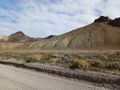
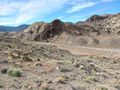
From where I left pavement near the intersection of US 6 and Nevada 773 to the hashpoint, and then continuing on to the mining camp at Silver Peak, was around 38 miles of unsigned dirt road. During that drive, I saw four other vehicles, so it wasn't the most remote road on Earth by any stretch. Still, I was glad to have redundant GPS, plus a pretty good little hand-drawn map I sketched on the way in.
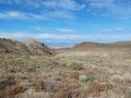
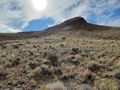
The hashpoint was about a quarter mile off the road and high enough up that it felt like exercise, but it wasn't an incredibly difficult climb. The views, both from the hashpoint and all along the drive, were very striking -- it felt like some kind of live-action Minecraft scenario, with longer days and fewer monsters.
Photos
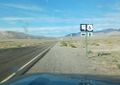
Turning left onto Nevada 773...
...and then immediately onto the dirt road to the left.
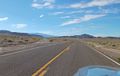
Driving across flats
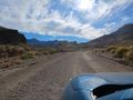
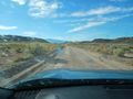
Driving up into hills
Looking up where I'm going to climb
Looking back down towards the vehicle
View down from the hashpoint
View up from the hashpoint
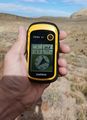
My GPS, at the hashpoint

Me, at the hashpoint


