Difference between revisions of "2023-10-09 36 -116"
Michael5000 (talk | contribs) (→Participants) |
Michael5000 (talk | contribs) |
||
| Line 16: | Line 16: | ||
== Participants == | == Participants == | ||
| − | [[User:Michael5000|Michael5000]] | + | [[User:Michael5000|Michael5000]] |
| − | == | + | == Expedition == |
| − | + | As I continued towards my conference after [[2023-10-09 37 -117]], there was plenty of time for a brief side trip to capture this one as well. I had noticed that the little track that goes out towards it from Nevada 374 was right where the highway enters Death Valley National Park, but I didn't expect that to matter especially. But as it happens, the Park is closed due to recent heavy rains, so the highway was closed right at that point, and when I arrived there was a bit of a carnival atmosphere as people chatted with the rangers at the blockade, took their picture at the park sign, and took their picture at the Welcome to Nevada sign, oddly positioned four or five miles from the California border. | |
| − | + | The little side road doesn't enter the park but had a pylon on it, so I unpacked my bike and rode about a mile in, then walked another half mile or so to the hashpoint. It was classic Death Valley -- it felt no more than comfortably warm, but was actually 92F -- so again it was nice to have redundant GPS and good landmarks. | |
| − | + | ||
| + | After taking pictures and retreating back to the vehicle, I chatted with the ranger at the roadblock a bit and, in the course of the conversation, I did something I've never done before: explained to a civilian what I was actually doing on a geohashing expedition. We agreed that it was basically Pokemon Go without the cartoon monsters. | ||
| − | + | And at that point, the adventure part of the trip was pretty much over. I continued towards Las Vegas for a far less exciting work conference. | |
| − | |||
== Photos == | == Photos == | ||
| − | |||
| − | |||
| − | |||
<gallery perrow="5"> | <gallery perrow="5"> | ||
| − | File:2023-10-09 36 -116 a.jpg| | + | File:2023-10-09 36 -116 a.jpg|Leaving Highway 95 at Beatty |
| − | File:2023-10-09 36 -116 | + | File:2023-10-09 36 -116 l.jpg|The roadblock at the Park entrance |
| − | File:2023-10-09 36 -116 | + | File:2023-10-09 36 -116 b.jpg|Bicycling down this little road... |
| − | File:2023-10-09 36 -116 | + | File:2023-10-09 36 -116 c.jpg|...and then down this watercourse... |
| − | File:2023-10-09 36 -116 | + | File:2023-10-09 36 -116 j.jpg|...and then leaving the bike. |
| − | File:2023-10-09 36 -116 | + | File:2023-10-09 36 -116 d.jpg|There! |
| − | File:2023-10-09 36 -116 | + | File:2023-10-09 36 -116 m.jpg|Redundant GPS capacity |
| − | File:2023-10-09 36 -116 | + | File:2023-10-09 36 -116 e.jpg|Me |
| − | File:2023-10-09 36 -116 | + | File:2023-10-09 36 -116 f.jpg|View #1 |
| − | File:2023-10-09 36 -116 | + | File:2023-10-09 36 -116 g.jpg|View #2 |
| − | File:2023-10-09 36 -116 | + | File:2023-10-09 36 -116 h.jpg|View #3 |
| − | File:2023-10-09 36 -116 | + | File:2023-10-09 36 -116 i.jpg|Hashcot |
| − | File:2023-10-09 36 -116 | + | File:2023-10-09 36 -116 k.jpg|Vehicle and Bike, well inside of Nevada |
</gallery> | </gallery> | ||
== Achievements == | == Achievements == | ||
{{#vardefine:ribbonwidth|100%}} | {{#vardefine:ribbonwidth|100%}} | ||
| − | + | {{Virgin graticule | |
| − | + | | latitude = 36 | |
| − | + | | longitude = -116 | |
| − | + | | date = 2023-10-09 | |
| − | + | | name = Michael5000 | |
| − | + | }} | |
| + | {{Multihash2 | ||
| − | + | | date = 2023-10-09 | |
| − | + | | count = 2 | |
| − | + | | name = Michael5000 | |
| − | + | }} | |
| − | + | __NOTOC__ | |
| − | |||
[[Category:Expeditions]] | [[Category:Expeditions]] | ||
| − | |||
[[Category:Expeditions with photos]] | [[Category:Expeditions with photos]] | ||
| − | |||
| − | |||
| − | |||
| − | |||
| − | |||
[[Category:Coordinates reached]] | [[Category:Coordinates reached]] | ||
| − | |||
| − | |||
| − | |||
| − | |||
| − | |||
| − | |||
| − | |||
| − | |||
| − | |||
| − | |||
| − | |||
| − | |||
| − | |||
| − | |||
| − | |||
| − | |||
| − | |||
| − | |||
Revision as of 02:03, 10 October 2023
| Mon 9 Oct 2023 in 36,-116: 36.8196925, -116.8616929 geohashing.info google osm bing/os kml crox |
Location
Near the east entrance to Death Valley National Park.
Participants
Expedition
As I continued towards my conference after 2023-10-09 37 -117, there was plenty of time for a brief side trip to capture this one as well. I had noticed that the little track that goes out towards it from Nevada 374 was right where the highway enters Death Valley National Park, but I didn't expect that to matter especially. But as it happens, the Park is closed due to recent heavy rains, so the highway was closed right at that point, and when I arrived there was a bit of a carnival atmosphere as people chatted with the rangers at the blockade, took their picture at the park sign, and took their picture at the Welcome to Nevada sign, oddly positioned four or five miles from the California border.
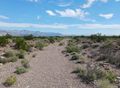
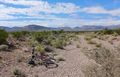
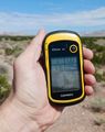
The little side road doesn't enter the park but had a pylon on it, so I unpacked my bike and rode about a mile in, then walked another half mile or so to the hashpoint. It was classic Death Valley -- it felt no more than comfortably warm, but was actually 92F -- so again it was nice to have redundant GPS and good landmarks.
After taking pictures and retreating back to the vehicle, I chatted with the ranger at the roadblock a bit and, in the course of the conversation, I did something I've never done before: explained to a civilian what I was actually doing on a geohashing expedition. We agreed that it was basically Pokemon Go without the cartoon monsters.
And at that point, the adventure part of the trip was pretty much over. I continued towards Las Vegas for a far less exciting work conference.
Photos
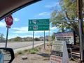
Leaving Highway 95 at Beatty
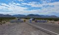
The roadblock at the Park entrance
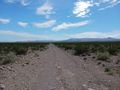
Bicycling down this little road...
...and then down this watercourse...
...and then leaving the bike.
There!
Redundant GPS capacity
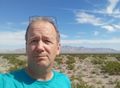
Me
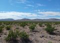
View #1
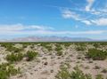
View #2
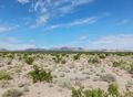
View #3
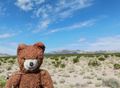
Hashcot
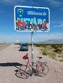
Vehicle and Bike, well inside of Nevada


Achievements
Michael5000 earned the Multihash Achievement
|