Difference between revisions of "2023-10-05 49 11"
([live picture]At the hash) |
(→Tracklog) |
||
| (5 intermediate revisions by 2 users not shown) | |||
| Line 40: | Line 40: | ||
== Tracklog == | == Tracklog == | ||
<!-- if your GPS device keeps a log, you may use Template:Tracklog, post a link here, or both --> | <!-- if your GPS device keeps a log, you may use Template:Tracklog, post a link here, or both --> | ||
| + | {{tracklog|Torodeas_20231005.gpx}} | ||
== Photos == | == Photos == | ||
| Line 50: | Line 51: | ||
Image:2023-10-05_49_11_Torodeas_1696527644249.jpg|At the hash | Image:2023-10-05_49_11_Torodeas_1696527644249.jpg|At the hash | ||
| + | |||
| + | Image:2023-10-05_49_11_Torodeas_1696527644274.jpg|View from the hash | ||
| + | |||
| + | Image:2023-10-05_49_11_Torodeas_1696527644280.jpg|Proof | ||
</gallery> | </gallery> | ||
| Line 56: | Line 61: | ||
<!-- Add any achievement ribbons you earned below, or remove this section --> | <!-- Add any achievement ribbons you earned below, or remove this section --> | ||
| + | {{land geohash | ||
| + | | date = 2023-10-05 | ||
| + | | latitude = 49 | ||
| + | | longitude = 11 | ||
| + | | name = [[User:Torodeas|Torodeas]] ([[User talk:Torodeas|talk]]) | ||
| + | }} | ||
| + | {{public transport geohash | ||
| + | | date = 2023-10-05 | ||
| + | | latitude = 49 | ||
| + | | longitude = 11 | ||
| + | | name = [[User:Torodeas|Torodeas]] ([[User talk:Torodeas|talk]]) | ||
| + | | busline = 20, 4, U3, RE16 | ||
| + | }} | ||
| + | |||
| + | {{Two to the N achievement | ||
| + | |||
| + | | count = 3 | ||
| + | | date = 2023-10-05 | ||
| + | | latitude = 49 | ||
| + | | longitude = 11 | ||
| + | | name = [[User:Torodeas|Torodeas]] ([[User talk:Torodeas|talk]]) | ||
| + | | reached = true | ||
| + | |||
| + | }} | ||
__NOTOC__ | __NOTOC__ | ||
<!-- =============== USEFUL CATEGORIES FOLLOW ================ | <!-- =============== USEFUL CATEGORIES FOLLOW ================ | ||
Delete the next line ONLY if you have chosen the appropriate categories below. If you are unsure, don't worry. People will read your report and help you with the classification. --> | Delete the next line ONLY if you have chosen the appropriate categories below. If you are unsure, don't worry. People will read your report and help you with the classification. --> | ||
| − | [[Category: | + | |
| + | [[Category:Expeditions]] | ||
| + | |||
| + | [[Category:Expeditions with photos]] | ||
| + | |||
| + | [[Category:Coordinates reached]] | ||
<!-- ==REQUEST FOR TWITTER BOT== Please leave either the New report or the Expedition planning category in as long as you work on it. This helps the twitter bot a lot with announcing the right outcome at the right moment. --> | <!-- ==REQUEST FOR TWITTER BOT== Please leave either the New report or the Expedition planning category in as long as you work on it. This helps the twitter bot a lot with announcing the right outcome at the right moment. --> | ||
| Line 98: | Line 132: | ||
(Don't forget to delete this final close comment marker) --> | (Don't forget to delete this final close comment marker) --> | ||
| + | {{location|DE|BY|RH}} | ||
Revision as of 17:06, 12 October 2023
| Thu 5 Oct 2023 in 49,11: 49.2070170, 11.0479392 geohashing.info google osm bing/os kml crox |
Location
In the woods near Oberheckenhofen
Participants
Plans
I'll take the train to Unterheckenhofen and walk from there. Hopefully I'm able to get back to the train station in less than 55 minutes to catch my train home.
Expedition
There are two paths from Unterheckenhofen towards the hash. The primary connection is east of the train tracks on a road - that presumably doesn't have any support for pedestrians. This also makes sense considering the hash is also east of the tracks, and I will not cross tracks 'in the wild'. But according to my scouting, there is also a path to the west of the tracks, crossing in an underbridge approx. 100 meters before the hash. I'll take that one, just because I don't like to walk on roads without pedestrian support. Maybe I should become more cofortable to pretend to be a car.
Just as my scouting suggested, the westerly path leads to an underpass under the tracks, and I follow the rarly used road only for my last 100 meters to get to the hash. Contrary to my scouting, the hash wasn't really in a forest - the road I've been walking on is very prominent in my picture taken at the hash. After locating the hash - that appears to be on the other side of the road than what I expected - I return to my train station, with enough time to spare to comfortable make my train home.
Tracklog
Photos
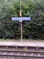
Unterheckenhofen train station
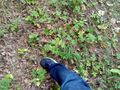
At the hash
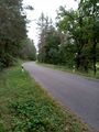
View from the hash

Proof


Achievements
Torodeas (talk) earned the Land geohash achievement
|
Torodeas (talk) earned the Public transport geohash achievement
|
