Difference between revisions of "2023-10-12 49 11"
([live picture]View from hash 1) |
m (Location) |
||
| (10 intermediate revisions by one other user not shown) | |||
| Line 14: | Line 14: | ||
== Location == | == Location == | ||
<!-- where you've surveyed the hash to be --> | <!-- where you've surveyed the hash to be --> | ||
| + | Near a road between Brand and Oberschöllenbach | ||
== Participants == | == Participants == | ||
<!-- who attended: If you link to your wiki user name in this section, your expedition will be picked up by the various statistics generated for geohashing. You may use three tildes ~ as a shortcut to automatically insert the user signature of the account you are editing with. | <!-- who attended: If you link to your wiki user name in this section, your expedition will be picked up by the various statistics generated for geohashing. You may use three tildes ~ as a shortcut to automatically insert the user signature of the account you are editing with. | ||
--> | --> | ||
| − | + | [[User:Torodeas|Torodeas]] ([[User talk:Torodeas|talk]]) | |
| − | |||
| − | |||
== Expedition == | == Expedition == | ||
<!-- how it all turned out. your narrative goes here. --> | <!-- how it all turned out. your narrative goes here. --> | ||
| + | I decided to go for this hash after work because it is - similar to [[2023-08-18_49_11]] - quite easy to reach with the high quality bus services leaving Erlangen eastwards. | ||
| + | I wouldn't be totally surprised to see [[User:Sp3pbn | Sp3pbn]] having been here a few hours ago, just because it is so accessible: | ||
| + | Within 40 minutes of leaving work, I arrive at my targeted bus stop less than 1km from the hash. And conveniently, the road that misses the hash by less than 20 meters is very easy to find, | ||
| + | and it has a pedestrian sidewalk. Yay! | ||
| + | |||
| + | I follow the road - it even gets to keep its sidewalk when I leave the town of Eckental - until I'm practically at the hash, | ||
| + | a point where I only have to change to the other side of the street to reach the hash. There's still one uncertainty: | ||
| + | According to my scouting, the hash could be slightly inside a field that is used agriculturally. | ||
| + | I do not want to walk on a field with crops growing there - I would handle it as if there was a 'No trespassing' sign. | ||
| + | But when I approach it, I notice two things. | ||
| + | First, the field isn't used for crops right now, and second, the hash is not on the field itself, but so close to the street that it's not used anyways. | ||
| + | So I get to reach the hash, take a few pictures and walk back to the Eschenau train station to start my way home. | ||
== Tracklog == | == Tracklog == | ||
<!-- if your GPS device keeps a log, you may use Template:Tracklog, post a link here, or both --> | <!-- if your GPS device keeps a log, you may use Template:Tracklog, post a link here, or both --> | ||
| + | {{tracklog|Torodeas_20231012.gpx}} | ||
== Photos == | == Photos == | ||
| Line 38: | Line 50: | ||
Image:2023-10-12_49_11_Torodeas_1697129463597.jpg|At the hash | Image:2023-10-12_49_11_Torodeas_1697129463597.jpg|At the hash | ||
| − | Image:2023-10- | + | Image:2023-10-12_49_11_Torodeas_1697129463662.jpg|View from hash 2 |
| + | |||
| + | Image:2023-10-12_49_11_Torodeas_1697129571885.jpg|View from hash 1 | ||
</gallery> | </gallery> | ||
== Achievements == | == Achievements == | ||
{{#vardefine:ribbonwidth|100%}} | {{#vardefine:ribbonwidth|100%}} | ||
| + | {{land geohash | ||
| + | | date = 2023-10-12 | ||
| + | | latitude = 49 | ||
| + | | longitude = 11 | ||
| + | | name = [[User:Torodeas|Torodeas]] ([[User talk:Torodeas|talk]]) | ||
| + | }} | ||
| + | {{public transport geohash | ||
| + | | date = 2023-10-12 | ||
| + | | latitude = 49 | ||
| + | | longitude = 11 | ||
| + | | name = [[User:Torodeas|Torodeas]] ([[User talk:Torodeas|talk]]) | ||
| + | | busline = 280, 209 | ||
| + | }} | ||
<!-- Add any achievement ribbons you earned below, or remove this section --> | <!-- Add any achievement ribbons you earned below, or remove this section --> | ||
| Line 48: | Line 75: | ||
<!-- =============== USEFUL CATEGORIES FOLLOW ================ | <!-- =============== USEFUL CATEGORIES FOLLOW ================ | ||
Delete the next line ONLY if you have chosen the appropriate categories below. If you are unsure, don't worry. People will read your report and help you with the classification. --> | Delete the next line ONLY if you have chosen the appropriate categories below. If you are unsure, don't worry. People will read your report and help you with the classification. --> | ||
| − | [[Category: | + | [[Category:Expeditions]] |
| + | [[Category:Expeditions with photos]] | ||
| + | [[Category:Coordinates reached]] | ||
<!-- ==REQUEST FOR TWITTER BOT== Please leave either the New report or the Expedition planning category in as long as you work on it. This helps the twitter bot a lot with announcing the right outcome at the right moment. --> | <!-- ==REQUEST FOR TWITTER BOT== Please leave either the New report or the Expedition planning category in as long as you work on it. This helps the twitter bot a lot with announcing the right outcome at the right moment. --> | ||
| Line 87: | Line 116: | ||
(Don't forget to delete this final close comment marker) --> | (Don't forget to delete this final close comment marker) --> | ||
| + | {{location|DE|BY|ERH}} | ||
Latest revision as of 17:42, 12 October 2023
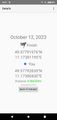
| Thu 12 Oct 2023 in 49,11: 49.5779198, 11.1738119 geohashing.info google osm bing/os kml crox |
Location
Near a road between Brand and Oberschöllenbach
Participants
Expedition
I decided to go for this hash after work because it is - similar to 2023-08-18_49_11 - quite easy to reach with the high quality bus services leaving Erlangen eastwards. I wouldn't be totally surprised to see Sp3pbn having been here a few hours ago, just because it is so accessible: Within 40 minutes of leaving work, I arrive at my targeted bus stop less than 1km from the hash. And conveniently, the road that misses the hash by less than 20 meters is very easy to find, and it has a pedestrian sidewalk. Yay!
I follow the road - it even gets to keep its sidewalk when I leave the town of Eckental - until I'm practically at the hash, a point where I only have to change to the other side of the street to reach the hash. There's still one uncertainty: According to my scouting, the hash could be slightly inside a field that is used agriculturally. I do not want to walk on a field with crops growing there - I would handle it as if there was a 'No trespassing' sign. But when I approach it, I notice two things. First, the field isn't used for crops right now, and second, the hash is not on the field itself, but so close to the street that it's not used anyways. So I get to reach the hash, take a few pictures and walk back to the Eschenau train station to start my way home.
Tracklog
Photos
Proof
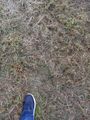
At the hash
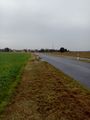
View from hash 2
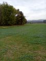
View from hash 1


Achievements
Torodeas (talk) earned the Land geohash achievement
|
Torodeas (talk) earned the Public transport geohash achievement
|