Difference between revisions of "2023-10-14 40 -116"
Michael5000 (talk | contribs) (→Expedition) |
Michael5000 (talk | contribs) (→Achievements) |
||
| Line 51: | Line 51: | ||
__NOTOC__ | __NOTOC__ | ||
| − | |||
| − | |||
| − | |||
| − | |||
| − | |||
| − | |||
| − | |||
| − | |||
| − | |||
| − | |||
| − | |||
| − | |||
| − | |||
[[Category:Expeditions]] | [[Category:Expeditions]] | ||
| − | |||
[[Category:Expeditions with photos]] | [[Category:Expeditions with photos]] | ||
| − | |||
| − | |||
| − | |||
| − | |||
| − | |||
[[Category:Coordinates reached]] | [[Category:Coordinates reached]] | ||
| − | |||
| − | |||
| − | |||
| − | |||
| − | |||
| − | |||
| − | |||
| − | |||
| − | |||
| − | |||
| − | |||
| − | |||
| − | |||
| − | |||
| − | |||
| − | |||
| − | |||
| − | |||
Revision as of 15:44, 15 October 2023
| Sat 14 Oct 2023 in 40,-116: 40.5873906, -116.9453599 geohashing.info google osm bing/os kml crox |
Location
Just south of Battle Mountain, Nevada.
Participants
Expedition
After the debacle at 2023-10-13 40 -111, I got some coffee in Heber City, found I-80 in Parkdale, stopped for a short run in Salt Lake City, stopped again for a short bike ride at Knolls in the Great Salt Flat, and refueled myself and the vehicle at nightfall in Wendover, at the Nevada-Utah state line.
From there, I continued for an hour or two until I got to Elko, where I found a dark residential street, put down the seat back, got out my blanket, and slept a couple of hours in the car. Waking at 2 a.m., I felt pretty alert, so I drove another hour to Battle Mountain and then a few miles south to the entry point for the hashpoint. I parked at the side of the country road, and then got another two or three hours of sleep.
At sunrise, I grabbed my eclipse-watchin' glasses and hiked the 1.5 km in to the hashpoint, which was another of the semi-desert landscapes that I've been exploring a lot on this trip. I was about a half-hour early for the eclipse, so I got in touch with nature by getting out my phone and playing Wordle, Waffle, Worldle, and so on.
Despite the desert landscape, it was a pretty cloudy morning and actually rained for a while. But, by the time the full eclipse came along, there were enough intermittent cloud breaks that I got a pretty good view of the action, sometimes through the filter glasses and sometimes through the clouds. By the way, although the photos make it look like an orange fire in a black sky, but that's just the filter talking. It turns out that daylight is pretty much daylight in a full annular eclipse. The light is... a bit dimmed, and kind of weird-looking, but if you were busy with something else it would be entirely possible to go through it without ever noticing that anything unusual was happening.
Photos
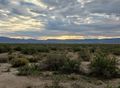
Sunrise from the hashpoint
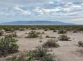
View the other direction
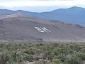
It stands for "Battle Mountain"
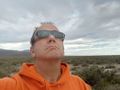
Me, eclipse-watchin' at the hashpoint
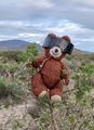
Hashcot, ditto
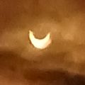
Partial
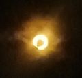
Full
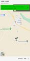
Location


