Difference between revisions of "2023-10-16 58 5"
From Geohashing
(→Location) |
(→Tracklog) |
||
| (9 intermediate revisions by the same user not shown) | |||
| Line 12: | Line 12: | ||
| date=2023-10-16 | | date=2023-10-16 | ||
}}<!-- edit as necessary --> | }}<!-- edit as necessary --> | ||
| + | [[Image:20231016 094101-2.jpg|thumb|left]] | ||
== Location == | == Location == | ||
<!-- where you've surveyed the hash to be --> | <!-- where you've surveyed the hash to be --> | ||
| Line 20: | Line 21: | ||
<!-- who attended: If you link to your wiki user name in this section, your expedition will be picked up by the various statistics generated for geohashing. You may use three tildes ~ as a shortcut to automatically insert the user signature of the account you are editing with. | <!-- who attended: If you link to your wiki user name in this section, your expedition will be picked up by the various statistics generated for geohashing. You may use three tildes ~ as a shortcut to automatically insert the user signature of the account you are editing with. | ||
--> | --> | ||
| + | |||
| + | *[[User:Pica42|Pica42]] | ||
== Plans == | == Plans == | ||
| Line 29: | Line 32: | ||
== Tracklog == | == Tracklog == | ||
<!-- if your GPS device keeps a log, you may use Template:Tracklog, post a link here, or both --> | <!-- if your GPS device keeps a log, you may use Template:Tracklog, post a link here, or both --> | ||
| + | |||
| + | On today's trip, the weather was fine with about 7 ºC. First 12 km by car, then approx. 500 meters on foot in a cow pasture that was in wet and rough terrain to walk on. | ||
== Photos == | == Photos == | ||
| Line 37: | Line 42: | ||
Image:2023-10-16_58_5_Pica42_1697442137329.jpg|Lye [https://openstreetmap.org/?mlat=58.73255470&mlon=5.72734470&zoom=16 @58.7326,5.7273] | Image:2023-10-16_58_5_Pica42_1697442137329.jpg|Lye [https://openstreetmap.org/?mlat=58.73255470&mlon=5.72734470&zoom=16 @58.7326,5.7273] | ||
| + | Image:20231016 58 5 W-2.jpg|thumb|View to the west | ||
| + | Image:20231016 58 5 S-2.jpg|thumb|View to the south | ||
| + | Image:20231016 58 5 E-2.jpg|thumb|View to the east | ||
| + | Image:20231016 58 5 N-2.jpg|thumb|View to the north | ||
| + | |||
</gallery> | </gallery> | ||
| Line 43: | Line 53: | ||
<!-- Add any achievement ribbons you earned below, or remove this section --> | <!-- Add any achievement ribbons you earned below, or remove this section --> | ||
| − | + | {{land geohash |name=[[User:Pica42|Pica42]] |date=2023-10-16 |latitude=58 |longitude=5 }} | |
| − | |||
| − | |||
| − | [[ | ||
| − | |||
| − | |||
| − | |||
| − | |||
| − | |||
| − | |||
| − | |||
| − | |||
| − | |||
| − | |||
| − | |||
[[Category:Expeditions]] | [[Category:Expeditions]] | ||
| − | |||
[[Category:Expeditions with photos]] | [[Category:Expeditions with photos]] | ||
| − | |||
| − | |||
| − | |||
| − | |||
| − | |||
[[Category:Coordinates reached]] | [[Category:Coordinates reached]] | ||
| + | {{location|NO|11}} | ||
| − | + | __NOTOC__ | |
| − | |||
| − | |||
| − | |||
| − | |||
| − | |||
| − | |||
| − | |||
| − | |||
| − | |||
| − | |||
| − | |||
| − | |||
| − | |||
| − | |||
| − | |||
| − | |||
Latest revision as of 13:52, 16 October 2023
| Mon 16 Oct 2023 in 58,5: 58.7325861, 5.7273543 geohashing.info google osm bing/os kml crox |

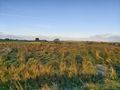
Location
In an uncultivated cow pasture at Lye, Time, Norway
Participants
Plans
Expedition
Tracklog
On today's trip, the weather was fine with about 7 ºC. First 12 km by car, then approx. 500 meters on foot in a cow pasture that was in wet and rough terrain to walk on.
Photos

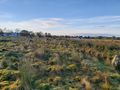
Lye @58.7326,5.7273
View to the west
View to the south
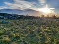
View to the east
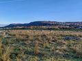
View to the north


Achievements
Pica42 earned the Land geohash achievement
|