Difference between revisions of "2023-10-20 59 5"
From Geohashing
(→Photos) |
(→Photos) |
||
| Line 43: | Line 43: | ||
Image:2023-10-20_59_5_Pica42_1697791356652.jpg|Tungenes [https://openstreetmap.org/?mlat=59.03600550&mlon=5.58170790&zoom=16 @59.0360,5.5817] | Image:2023-10-20_59_5_Pica42_1697791356652.jpg|Tungenes [https://openstreetmap.org/?mlat=59.03600550&mlon=5.58170790&zoom=16 @59.0360,5.5817] | ||
Image:20231020 58 5 N.jpg|thumb|View to the north | Image:20231020 58 5 N.jpg|thumb|View to the north | ||
| − | + | Image:20231020 58 5 W.jpg|thumb|View to the west | |
Revision as of 18:49, 29 October 2023
| Fri 20 Oct 2023 in 59,5: 59.0359762, 5.5816450 geohashing.info google osm bing/os kml crox |

Location
Near Tungenes lighthouse, Randaberg, Norway
Participants
Plans
Expedition
It was quite a windy trip to Tungenes lighthouse today.
Tracklog
Photos

Tungenes @59.0360,5.5817
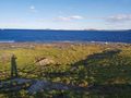
View to the north
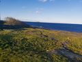
View to the west


Achievements
Pica42 earned the Land geohash achievement
|