Difference between revisions of "2023-10-20 59 5"
From Geohashing
(→Participants) |
(→Expedition) |
||
| (10 intermediate revisions by the same user not shown) | |||
| Line 12: | Line 12: | ||
| date=2023-10-20 | | date=2023-10-20 | ||
}}<!-- edit as necessary --> | }}<!-- edit as necessary --> | ||
| + | [[Image:20231020_104148-2.jpg|thumb|left]] | ||
== Location == | == Location == | ||
<!-- where you've surveyed the hash to be --> | <!-- where you've surveyed the hash to be --> | ||
| Line 28: | Line 29: | ||
== Expedition == | == Expedition == | ||
<!-- how it all turned out. your narrative goes here. --> | <!-- how it all turned out. your narrative goes here. --> | ||
| + | |||
| + | It was quite a windy trip to Tungenes lighthouse today. Even though it was a bit cold, it was a great trip. | ||
== Tracklog == | == Tracklog == | ||
| Line 39: | Line 42: | ||
Image:2023-10-20_59_5_Pica42_1697791356652.jpg|Tungenes [https://openstreetmap.org/?mlat=59.03600550&mlon=5.58170790&zoom=16 @59.0360,5.5817] | Image:2023-10-20_59_5_Pica42_1697791356652.jpg|Tungenes [https://openstreetmap.org/?mlat=59.03600550&mlon=5.58170790&zoom=16 @59.0360,5.5817] | ||
| + | Image:20231020 58 5 N.jpg|thumb|View to the north | ||
| + | Image:20231020 58 5 W.jpg|thumb|View to the west | ||
| + | Image:20231020 58 5 S.jpg|thumb|View to the south | ||
| + | Image:20231020 58 5 E.jpg|thumb|View to the east | ||
</gallery> | </gallery> | ||
| Line 45: | Line 52: | ||
<!-- Add any achievement ribbons you earned below, or remove this section --> | <!-- Add any achievement ribbons you earned below, or remove this section --> | ||
| − | + | {{land geohash |name=[[User:Pica42|Pica42]] |date=2023-10-20 |latitude=59 |longitude=5 }} | |
| − | |||
| − | |||
| − | [[ | ||
| − | |||
| − | |||
| − | |||
| − | |||
| − | |||
| − | |||
| − | |||
| − | |||
| − | |||
| − | |||
| − | |||
[[Category:Expeditions]] | [[Category:Expeditions]] | ||
| − | |||
[[Category:Expeditions with photos]] | [[Category:Expeditions with photos]] | ||
| − | |||
| − | |||
| − | |||
| − | |||
| − | |||
[[Category:Coordinates reached]] | [[Category:Coordinates reached]] | ||
| + | {{location|NO|11}} | ||
| − | + | __NOTOC__ | |
| − | |||
| − | |||
| − | |||
| − | |||
| − | |||
| − | |||
| − | |||
| − | |||
| − | |||
| − | |||
| − | |||
| − | |||
| − | |||
| − | |||
| − | |||
Latest revision as of 18:59, 29 October 2023
| Fri 20 Oct 2023 in 59,5: 59.0359762, 5.5816450 geohashing.info google osm bing/os kml crox |

Location
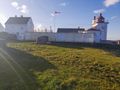
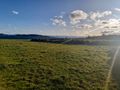
Near Tungenes lighthouse, Randaberg, Norway
Participants
Plans
Expedition
It was quite a windy trip to Tungenes lighthouse today. Even though it was a bit cold, it was a great trip.
Tracklog
Photos
Tungenes @59.0360,5.5817
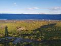
View to the north
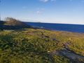
View to the west
View to the south
View to the east


Achievements
Pica42 earned the Land geohash achievement
|