Difference between revisions of "2023-10-08 38 -122"
From Geohashing
Coyotebush (talk | contribs) ([live picture]On the point [https://openstreetmap.org/?mlat=38.40248611&mlon=-122.73537778&zoom=16 @38.4025,-122.7354]) |
m (Location) |
||
| (2 intermediate revisions by one other user not shown) | |||
| Line 1: | Line 1: | ||
| − | + | {{meetup graticule | |
| − | |||
| − | |||
| − | |||
| − | |||
| − | |||
| − | |||
| − | |||
| − | |||
| lat=38 | | lat=38 | ||
| lon=-122 | | lon=-122 | ||
| date=2023-10-08 | | date=2023-10-08 | ||
| − | }} | + | }} |
== Location == | == Location == | ||
| − | + | Elsie Allen High School sports fields. | |
== Participants == | == Participants == | ||
<!-- who attended: If you link to your wiki user name in this section, your expedition will be picked up by the various statistics generated for geohashing. You may use three tildes ~ as a shortcut to automatically insert the user signature of the account you are editing with. | <!-- who attended: If you link to your wiki user name in this section, your expedition will be picked up by the various statistics generated for geohashing. You may use three tildes ~ as a shortcut to automatically insert the user signature of the account you are editing with. | ||
--> | --> | ||
| + | [[User:Coyotebush|coyotebush]] | ||
== Plans == | == Plans == | ||
| − | + | Returning from a weekend in the west county, Mom and I would already be passing through the general area. Once I got the notification in the morning, it was an easy decision to make a stop on the way. | |
== Expedition == | == Expedition == | ||
| − | + | We parked on Bellevue Ave within 100m of the point and walked up the creek trail along the south side of the field. However, the field turned out to be thoroughly fenced in, and partway up the east side of the field Mom turned back to get the car. I eventually found a gate near the northeast corner and headed diagonally across the field to the point. Captured proof, then back to the gate and the car. | |
| − | |||
| − | |||
== Photos == | == Photos == | ||
| Line 37: | Line 28: | ||
Image:2023-10-08_38_-122_coyotebush_1696793601187.jpg|On the point [https://openstreetmap.org/?mlat=38.40248611&mlon=-122.73537778&zoom=16 @38.4025,-122.7354] | Image:2023-10-08_38_-122_coyotebush_1696793601187.jpg|On the point [https://openstreetmap.org/?mlat=38.40248611&mlon=-122.73537778&zoom=16 @38.4025,-122.7354] | ||
| + | |||
| + | Image:2023-10-08_38_-122_coyotebush_1696793652006.jpg|Map | ||
</gallery> | </gallery> | ||
| − | |||
| − | |||
| − | |||
__NOTOC__ | __NOTOC__ | ||
| − | |||
| − | |||
| − | |||
| − | |||
| − | |||
| − | |||
| − | |||
| − | |||
| − | |||
| − | |||
| − | |||
| − | |||
[[Category:Expeditions]] | [[Category:Expeditions]] | ||
| − | |||
[[Category:Expeditions with photos]] | [[Category:Expeditions with photos]] | ||
| − | |||
| − | |||
| − | |||
| − | |||
| − | |||
[[Category:Coordinates reached]] | [[Category:Coordinates reached]] | ||
| − | + | {{location|US|CA|SO}} | |
| − | |||
| − | |||
| − | |||
| − | |||
| − | |||
| − | |||
| − | |||
| − | |||
| − | |||
| − | |||
| − | |||
| − | |||
| − | |||
| − | |||
| − | |||
| − | |||
| − | |||
Latest revision as of 21:42, 4 November 2023
| Sun 8 Oct 2023 in 38,-122: 38.4024858, -122.7353894 geohashing.info google osm bing/os kml crox |
Location
Elsie Allen High School sports fields.
Participants
Plans
Returning from a weekend in the west county, Mom and I would already be passing through the general area. Once I got the notification in the morning, it was an easy decision to make a stop on the way.
Expedition
We parked on Bellevue Ave within 100m of the point and walked up the creek trail along the south side of the field. However, the field turned out to be thoroughly fenced in, and partway up the east side of the field Mom turned back to get the car. I eventually found a gate near the northeast corner and headed diagonally across the field to the point. Captured proof, then back to the gate and the car.
Photos
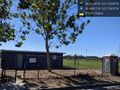
Field entrance @38.4041,-122.7331
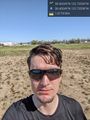
On the point @38.4025,-122.7354

Map


