Difference between revisions of "2010-01-02 59 17"
(Created page with ' the ru and Elin intend to go and will be travelling by subway from T-Centralen. We'll be there around 16:00 if everything goes well. [[Category:Expedition plan…') |
m |
||
| (17 intermediate revisions by 5 users not shown) | |||
| Line 1: | Line 1: | ||
| − | + | __NOTOC__{{meetup graticule | |
| + | | lat=59 | ||
| + | | lon=17 | ||
| + | | date=2010-01-02 | ||
| + | }} | ||
| + | == Location == | ||
| + | Dybecksvägen in Södra Ängby, a suburb of Stockholm. Only a few minutes from the Ängbyplan subway station. | ||
| − | [[Category: | + | == [[User:the_ru | the ru]] and Elin == |
| + | Arriving from different directions, we converged at the central station in Stockholm. Elins train was delayed, so the ru had an hour to wander aimlessly around the city. He found a park, but failed to bring photographic evidence. | ||
| + | |||
| + | A rather uneventful ride with subway line T19 brought us to the proper station, after that it was just a short walk. the ru was a bit disappointed that the supposed "subway" was really above ground most of the distance. | ||
| + | |||
| + | |||
| + | {{land geohash | ||
| + | | latitude = 59 | ||
| + | | longitude = 17 | ||
| + | | date = 2010-01-02 | ||
| + | | name = Elin | ||
| + | }} | ||
| + | |||
| + | |||
| + | {{Public transport geohash | ||
| + | | latitude = 59 | ||
| + | | longitude = 17 | ||
| + | | date = 2010-01-02 | ||
| + | | busline = Stockholm subway | ||
| + | | name = Elin | ||
| + | }} | ||
| + | |||
| + | |||
| + | {{Public transport geohash | ||
| + | | latitude = 59 | ||
| + | | longitude = 17 | ||
| + | | date = 2010-01-02 | ||
| + | | busline = Stockholm subway | ||
| + | | name = [[User:the ru | the ru]] | ||
| + | }} | ||
| + | |||
| + | |||
| + | == Photos == | ||
| + | <gallery perrow="3"> | ||
| + | Image:2010-01-02_59_17_subway.jpg | Ordinary (non-geohashing) people commuting | ||
| + | Image:2010-01-02_59_17_subway3.jpg | Interior of subway train | ||
| + | |||
| + | Image:2010-01-02_59_17_platform.jpg | ''Artistic impression'' of the Ängbyplan subway platform | ||
| + | Image:2010-01-02_59_17_cameras.jpg | Surveillance cameras at the platform | ||
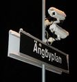
| + | Image:2010-01-02_59_17_station.jpg | Ängbyplan | ||
| + | |||
| + | Image:2010-01-02_59_17_hash_west.jpg | View west from the hashpoint | ||
| + | |||
| + | Image:2010-01-02_59_17_login.jpg | Information screen at central station, the IT department seems to be doing their job properly (?) | ||
| + | Image:2010-01-02_59_17_plattan.jpg | [http://en.wikipedia.org/wiki/Sergels_torg Plattan], the heart of Stockholm. This is where the junkies hang out. | ||
| + | Image:2010-01-02_59_17_stamps.jpg | the ru managed to get his ticket stamped thrice in a row. Normally, each trip costs two coupons. Not fully aware how the system worked, he somehow negotiated something different with the ticket clerks. | ||
| + | |||
| + | </gallery> | ||
| + | |||
| + | [[Category:Expeditions]] | ||
| + | [[Category:Expeditions with photos]] | ||
| + | [[Category:Coordinates reached]] | ||
| + | {{location|SE|AB}} | ||
Latest revision as of 00:24, 29 November 2023
| Sat 2 Jan 2010 in 59,17: 59.3444998, 17.9069854 geohashing.info google osm bing/os kml crox |
Location
Dybecksvägen in Södra Ängby, a suburb of Stockholm. Only a few minutes from the Ängbyplan subway station.
the ru and Elin
Arriving from different directions, we converged at the central station in Stockholm. Elins train was delayed, so the ru had an hour to wander aimlessly around the city. He found a park, but failed to bring photographic evidence.
A rather uneventful ride with subway line T19 brought us to the proper station, after that it was just a short walk. the ru was a bit disappointed that the supposed "subway" was really above ground most of the distance.
Elin earned the Land geohash achievement
|
Elin earned the Public transport geohash achievement
|
the ru earned the Public transport geohash achievement
|
Photos
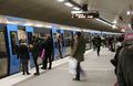
Ordinary (non-geohashing) people commuting
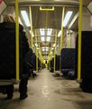
Interior of subway train
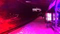
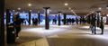
Artistic impression of the Ängbyplan subway platform
Surveillance cameras at the platform
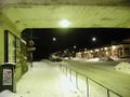
Ängbyplan
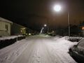
View west from the hashpoint
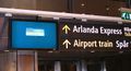
Information screen at central station, the IT department seems to be doing their job properly (?)
Plattan, the heart of Stockholm. This is where the junkies hang out.
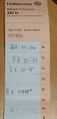
the ru managed to get his ticket stamped thrice in a row. Normally, each trip costs two coupons. Not fully aware how the system worked, he somehow negotiated something different with the ticket clerks.


