Difference between revisions of "2023-11-29 58 5"
From Geohashing
(→Achievements) |
|||
| (10 intermediate revisions by the same user not shown) | |||
| Line 29: | Line 29: | ||
== Expedition == | == Expedition == | ||
<!-- how it all turned out. your narrative goes here. --> | <!-- how it all turned out. your narrative goes here. --> | ||
| + | |||
| + | This time it was an early geohash trip. It was only 08:30 in the morning and it was not quite light when I walked the 570 meters from home to the hash point for today. It was difficult to get all the way to zero piont, but I think this was close enough. | ||
== Tracklog == | == Tracklog == | ||
| Line 40: | Line 42: | ||
Image:2023-11-29_58_5_Pica42_1701244198600.jpg|Verdalen [https://openstreetmap.org/?mlat=58.78667160&mlon=5.61446910&zoom=16 @58.7867,5.6145] | Image:2023-11-29_58_5_Pica42_1701244198600.jpg|Verdalen [https://openstreetmap.org/?mlat=58.78667160&mlon=5.61446910&zoom=16 @58.7867,5.6145] | ||
| + | Image:20231129 58 5 SE.jpg|thumb|View to the southeast | ||
| + | Image:20231129 58 5 NE.jpg|thumb|View to the northeast | ||
| + | Image:20231129 58 5 NW.jpg|thumb|View to the northwest | ||
| + | Image:20231129 58 5 SW.jpg|thumb|View to the southwest | ||
</gallery> | </gallery> | ||
| Line 46: | Line 52: | ||
<!-- Add any achievement ribbons you earned below, or remove this section --> | <!-- Add any achievement ribbons you earned below, or remove this section --> | ||
| − | + | {{land geohash |name=[[User:Pica42|Pica42]] |date=2023-11-29 |latitude=58 |longitude=5 }} | |
| − | |||
| − | |||
| − | [[ | ||
| − | |||
| − | |||
| − | |||
| − | |||
| − | |||
| − | |||
| − | |||
| − | |||
| − | |||
| − | |||
| − | |||
[[Category:Expeditions]] | [[Category:Expeditions]] | ||
| − | |||
[[Category:Expeditions with photos]] | [[Category:Expeditions with photos]] | ||
| − | |||
| − | |||
| − | |||
| − | |||
| − | |||
[[Category:Coordinates reached]] | [[Category:Coordinates reached]] | ||
| − | + | {{location|NO|11}} | |
| − | + | {{Walk geohash | |
| − | + | | latitude = 58 | |
| − | + | | longitude = 5 | |
| − | + | | date = 2023-11-29 | |
| − | + | | name = [[User:pica42|pica42]] | |
| − | + | | distance = 1,14 km home - hash - home }} | |
| − | + | __NOTOC__ | |
| − | |||
| − | [[ | ||
| − | |||
| − | |||
| − | |||
| − | |||
| − | |||
| − | |||
| − | |||
| − | |||
Latest revision as of 17:57, 30 November 2023
| Wed 29 Nov 2023 in 58,5: 58.7865517, 5.6144423 geohashing.info google osm bing/os kml crox |

Location
Near a road in Verdalen, Klepp, Norway
Participants
Plans
Expedition
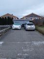
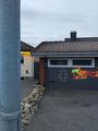
This time it was an early geohash trip. It was only 08:30 in the morning and it was not quite light when I walked the 570 meters from home to the hash point for today. It was difficult to get all the way to zero piont, but I think this was close enough.
Tracklog
Photos

Verdalen @58.7867,5.6145
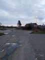
View to the southeast
View to the northeast
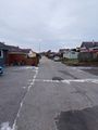
View to the northwest
View to the southwest


Achievements
Pica42 earned the Land geohash achievement
|
pica42 earned the Walk geohash Achievement
|