Difference between revisions of "2023-11-17 -37 144"
From Geohashing
(→Location) |
m (Location) |
||
| (5 intermediate revisions by 3 users not shown) | |||
| Line 1: | Line 1: | ||
| − | + | [[Image:{{{image|Geohash 2023-11-17 -37 144 01 Hash.jpg}}}|thumb|left]] | |
| − | + | {{meetup graticule | |
| − | |||
| − | |||
| − | |||
| − | |||
| − | |||
| − | |||
| lat=-37 | | lat=-37 | ||
| lon=144 | | lon=144 | ||
| date=2023-11-17 | | date=2023-11-17 | ||
| − | }} | + | }} |
| + | |||
== Location == | == Location == | ||
| − | |||
In something paddockish in Point Cook Costal Park. | In something paddockish in Point Cook Costal Park. | ||
== Participants == | == Participants == | ||
| − | + | * [[User:Lachie|Lachie]] | |
| − | + | * [[User:Johnwrw|John]] | |
| + | * Bridget | ||
| − | == | + | == Expedition == |
| − | + | The intrepid geohashers all met up after 5pm at Farnsworth Bridge and headed along the coast towards the hash with their bikes. The hash was reached before sunset at 7:22pm. | |
| − | + | After the hash they had dinner at the Phoenix Hotel, with Lachie having a pint of Hard Solo(TM). | |
| − | + | ||
| + | They returned via train. | ||
== Tracklog == | == Tracklog == | ||
| − | + | *https://ridewithgps.com/routes/44998831 [https://ridewithgps.com/routes/44998831] | |
== Photos == | == Photos == | ||
| − | |||
| − | |||
| − | |||
<gallery perrow="5"> | <gallery perrow="5"> | ||
| − | + | File:Geohash 2023-11-17 -37 144 01 Hash.jpg|At the hash | |
| − | Image:2023-11-17_-37_144_lachie_1700364952924.jpg| | + | Image:2023-11-17_-37_144_lachie_1700364952924.jpg|Sunset success |
| + | File:Geohash 2023-11-17 -37 144 02 Pub.jpeg|Hard Solo(TM) | ||
</gallery> | </gallery> | ||
== Achievements == | == Achievements == | ||
{{#vardefine:ribbonwidth|100%}} | {{#vardefine:ribbonwidth|100%}} | ||
| − | |||
| − | + | {{bicycle geohash | |
| − | |||
| − | |||
| − | |||
| − | + | | latitude = -37 | |
| + | | longitude = 144 | ||
| + | | date = 2023-11-17 | ||
| + | | name = John, Lachie and Bridget | ||
| + | | distance = 44kms | ||
| + | | bothways = false | ||
| + | | image = 2023-11-17_-37_144_lachie_1700364952924.jpg | ||
| − | + | }} | |
| − | |||
| − | |||
| − | |||
| − | + | __NOTOC__ | |
| − | |||
[[Category:Expeditions]] | [[Category:Expeditions]] | ||
| − | |||
[[Category:Expeditions with photos]] | [[Category:Expeditions with photos]] | ||
| − | |||
| − | |||
| − | |||
| − | |||
| − | |||
[[Category:Coordinates reached]] | [[Category:Coordinates reached]] | ||
| − | + | {{location|AU|VIC|WY}} | |
| − | |||
| − | |||
| − | |||
| − | |||
| − | |||
| − | |||
| − | |||
| − | |||
| − | |||
| − | |||
| − | |||
| − | |||
| − | |||
| − | |||
| − | |||
| − | |||
| − | |||
Latest revision as of 10:43, 1 December 2023
| Fri 17 Nov 2023 in -37,144: -37.9204789, 144.7839464 geohashing.info google osm bing/os kml crox |
Location
In something paddockish in Point Cook Costal Park.
Participants
Expedition
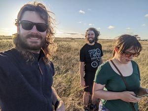
The intrepid geohashers all met up after 5pm at Farnsworth Bridge and headed along the coast towards the hash with their bikes. The hash was reached before sunset at 7:22pm.
After the hash they had dinner at the Phoenix Hotel, with Lachie having a pint of Hard Solo(TM).
They returned via train.
Tracklog
Photos
Achievements
John, Lachie and Bridget earned the Bicycle geohash achievement
|


