Difference between revisions of "2023-12-20 31 34"
Yerushalmi (talk | contribs) (Created page with "{{subst:Expedition}}") |
Yerushalmi (talk | contribs) |
||
| Line 13: | Line 13: | ||
}}<!-- edit as necessary --> | }}<!-- edit as necessary --> | ||
== Location == | == Location == | ||
| − | + | A grove of untended trees in the middle of agricultural land as far as the eye can see. Very, very far from any roads. | |
== Participants == | == Participants == | ||
| − | + | [[User:Yerushalmi|Yerushalmi]] ([[User talk:Yerushalmi|talk]]) | |
| − | |||
== Plans == | == Plans == | ||
| − | + | The weather is clear and the rocket forecast for that area is green. I'll take the train to Tel Aviv, switch to the train to Kiryat Gat, and take a bus to the station outside Moshav Zohar (northwest of the point). From there it's a 45-minute walk on dirt roads between the fields, during which I will have to cross a set of train tracks and a river. Do the reverse for the way home. | |
| + | |||
| + | This will be the longest and most ambitious hash I've attempted so far. | ||
== Expedition == | == Expedition == | ||
| − | + | The train ride to Kiryat Gat went almost without a hitch. I left my lunch on the train, but one of the conductors actually held it up for me so I could run back and get it, for which I thanked him profusely. | |
| + | |||
| + | Once I arrived, I took a bus from the train station to the bus station (my third time this month at that bus station - I'm getting kind of tired of Kiryat Gat points). This is also how I learned that my [[2023-12-17_31_34|inability to find the 66 bus]] during a previous hash was my fault, not Moovit's. I had been waiting at the wrong bus stop. | ||
| + | |||
| + | I had about an hour's wait for the 240 bus to Sderot, so I sat and ate lunch, did some Halacha Yomit, and bought some classical music online. I took the bus at Moshav Zohar without incident; no intermittent GPS jamming this time! | ||
| − | + | Now I had to walk down route 352 (the yellow line in the screenshot below), at some point cross it, then go into the fields. I intended on doing this at the moment the route curved to the west, but I was engrossed in a phone call with my brother and didn't notice that I passed that point and reached where route 352 goes over the train tracks. At first I was thrilled at my good luck: had I gotten off where I intended, I'd have had to double-back to 352 because there was no other place to cross. But then I realized that this was just about the only place in the country where the tracks are not fenced off; I could've crossed at any point I wanted (though it would've obviously been less safe). | |
| − | + | ||
| + | [[File:20231220 crossing.png|400px]] | ||
| + | |||
| + | From there it was a brisk walk with some amazing views that I put in the photo gallery. I was constantly hearing planes overhead and booms in the distance from the war against Hamas. | ||
| + | |||
| + | Now, one thing to note is that often a lot of the adjacent fields are owned by the same person or group. So they're constantly merging and splitting them in ways that mean the paths on the satellite photo aren't always the same as in reality. That's how I ended up here: | ||
| + | |||
| + | [[File:20231220 lines.png|400px]] | ||
| + | |||
| + | That's the entrance to, rather than an open field, a grove of trees. Recalling [[2023-12-10_32_35|the last time I had to cross a river]] and the massive wall of thorns that blocked my way, I wanted to make sure to reach the river at the thinnest point possible. This meant picking a good row to walk down if I didn't want to take a massive detour around the orchard. But what with the war and everything, people are on edge; the last thing I need is to frighten the owner of the field by appearing out of nowhere, or worse, to be heard walking through it, be considered suspicious, and have the police or army called on me. What to do? | ||
| + | |||
| + | After a few moments I hit on a solution: I had my phone play an English-language podcast on full blast. That would make it clear I'm not trying to hide and I'm just an innocent idiot walking in the wrong place. (I needn't have bothered; nobody was around for miles.) | ||
| + | |||
| + | Then I reached the river, and I discovered that far from being a wall of thorns, it was a descent into a verdant paradise of a dry riverbed. | ||
| + | |||
| + | [[File:20231220_133013.jpg|400px]] | ||
| + | |||
| + | I climbed out of the riverbed on the other side and began walking around the next orchard to reach the point, when I realized I had been silly: the point was clearly in a branch of the same riverbed and I could've stayed inside. But no matter, I walked to the closest edge of the riverbed and climbed into it, reaching the point shortly thereafter. | ||
| + | |||
| + | It was the most peaceful place I've ever been in my life. The grass all around me, the canopy of trees, the sun shining almost mystically through a haze that didn't exist moments earlier, all that compounded with the runner's high of walking so long and the thrill of reaching my goal... it was just magical. Between the war and losing my job six months ago and all of the other stresses of life, I'd long wanted to go someplace where I could be alone and scream my lungs out to release the stress, but now that I was there, I just felt no need to do so. | ||
| + | |||
| + | I stood there for five or ten minutes just taking it in. | ||
| + | |||
| + | Okay, time to go home. I pulled out Moovit, which is much better at guiding you ''from'' the middle of nowhere than ''to'' the middle of nowhere. It actually said that a faster route back to the Kiryat Gat train station would be to head east rather than north, and take a bus from the town of Even Shmuel. Which I loved, because it meant I'd have a completely different route on the way back. | ||
| + | |||
| + | There isn't much to say about the route back; no interesting detours. At one point I passed a set of fields where people were actively working, and they looked at me curiously as I walked by. And at one point I passed directly between an orange grove on one side and a lemon grove on the other, which made me think of 1984. I made it to the bus stop in time, took the bus to the Kiryat Gat train station, and the train back home. | ||
== Photos == | == Photos == | ||
| − | |||
| − | |||
| − | |||
<gallery perrow="5"> | <gallery perrow="5"> | ||
| + | File:20231220_123041.jpg | Fields on the way | ||
| + | File:20231220_123430.jpg | The bus stop I got off at | ||
| + | File:20231220_123921.jpg | Somebody wrapped a bunch of rocks in a metal fence? What? | ||
| + | File:20231220_125324.jpg | On the bridge over the train tracks. I did not see or hear any trains at any point. | ||
| + | File:20231220_130630.jpg | Panorama in the middle of a bunch of fields (not at the point) | ||
| + | File:20231220_132041.jpg | The grove of trees that I walked down while listening to the Dispatch Podcast. I'm not a botanist. | ||
| + | File:20231220_133013.jpg | Riverbed | ||
| + | File:20231220_133025.jpg | Utterly beautiful. | ||
| + | File:20231220_133028.jpg | ||
| + | File:20231220_133151.jpg | Panorama inside the riverbed (still not at the point, and before I realized the point would also be in the riverbed) | ||
| + | File:20231220_133347.jpg | Creepy tree | ||
| + | File:20231220_133459.jpg | Barkless tree | ||
| + | File:20231220_134744.jpg | Yellow mold tree | ||
| + | File:20231220_134910.jpg | Approaching the point. There was for some reason a large patch of grass covered in filmy dew, where no other grass was even wet | ||
| + | File:Screenshot_20231220_135148_Geohash Droid.jpg | Proof | ||
| + | File:20231220_135201.jpg | Panorama at the point | ||
| + | File:20231220_140326.jpg | ||
| + | File:20231220_141503.jpg | ||
| + | File:20231220_143032.jpg | Oranges | ||
| + | File:20231220_144620.jpg | and lemons | ||
| + | File:20231220_144636.jpg | say the bells of St. Clement's | ||
| + | File:20231220_150720.jpg | Orange trees in the middle of the town of Eitan | ||
| + | File:20231220_151201.jpg | Combine harvesters | ||
| + | File:20231220_151355.jpg | An honest-to-god tumbleweed! Never seen one in real life. | ||
| + | |||
</gallery> | </gallery> | ||
| − | |||
| − | |||
| − | |||
| − | |||
__NOTOC__ | __NOTOC__ | ||
<!-- =============== USEFUL CATEGORIES FOLLOW ================ | <!-- =============== USEFUL CATEGORIES FOLLOW ================ | ||
Delete the next line ONLY if you have chosen the appropriate categories below. If you are unsure, don't worry. People will read your report and help you with the classification. --> | Delete the next line ONLY if you have chosen the appropriate categories below. If you are unsure, don't worry. People will read your report and help you with the classification. --> | ||
| − | |||
| − | |||
| − | |||
| − | |||
| − | |||
| − | |||
| − | |||
| − | |||
| − | |||
| − | |||
| − | |||
[[Category:Expeditions]] | [[Category:Expeditions]] | ||
| − | |||
[[Category:Expeditions with photos]] | [[Category:Expeditions with photos]] | ||
| − | |||
| − | |||
| − | |||
| − | |||
| − | |||
[[Category:Coordinates reached]] | [[Category:Coordinates reached]] | ||
| − | |||
| − | |||
| − | |||
| − | |||
| − | |||
| − | |||
| − | |||
| − | |||
| − | |||
| − | |||
| − | |||
| − | |||
| − | |||
| − | |||
| − | |||
| − | |||
| − | |||
| − | |||
Revision as of 15:46, 25 December 2023
| Wed 20 Dec 2023 in 31,34: 31.5723420, 34.7135104 geohashing.info google osm bing/os kml crox |
Location
A grove of untended trees in the middle of agricultural land as far as the eye can see. Very, very far from any roads.
Participants
Plans
The weather is clear and the rocket forecast for that area is green. I'll take the train to Tel Aviv, switch to the train to Kiryat Gat, and take a bus to the station outside Moshav Zohar (northwest of the point). From there it's a 45-minute walk on dirt roads between the fields, during which I will have to cross a set of train tracks and a river. Do the reverse for the way home.
This will be the longest and most ambitious hash I've attempted so far.
Expedition
The train ride to Kiryat Gat went almost without a hitch. I left my lunch on the train, but one of the conductors actually held it up for me so I could run back and get it, for which I thanked him profusely.
Once I arrived, I took a bus from the train station to the bus station (my third time this month at that bus station - I'm getting kind of tired of Kiryat Gat points). This is also how I learned that my inability to find the 66 bus during a previous hash was my fault, not Moovit's. I had been waiting at the wrong bus stop.
I had about an hour's wait for the 240 bus to Sderot, so I sat and ate lunch, did some Halacha Yomit, and bought some classical music online. I took the bus at Moshav Zohar without incident; no intermittent GPS jamming this time!
Now I had to walk down route 352 (the yellow line in the screenshot below), at some point cross it, then go into the fields. I intended on doing this at the moment the route curved to the west, but I was engrossed in a phone call with my brother and didn't notice that I passed that point and reached where route 352 goes over the train tracks. At first I was thrilled at my good luck: had I gotten off where I intended, I'd have had to double-back to 352 because there was no other place to cross. But then I realized that this was just about the only place in the country where the tracks are not fenced off; I could've crossed at any point I wanted (though it would've obviously been less safe).

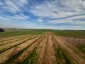
From there it was a brisk walk with some amazing views that I put in the photo gallery. I was constantly hearing planes overhead and booms in the distance from the war against Hamas.
Now, one thing to note is that often a lot of the adjacent fields are owned by the same person or group. So they're constantly merging and splitting them in ways that mean the paths on the satellite photo aren't always the same as in reality. That's how I ended up here:

That's the entrance to, rather than an open field, a grove of trees. Recalling the last time I had to cross a river and the massive wall of thorns that blocked my way, I wanted to make sure to reach the river at the thinnest point possible. This meant picking a good row to walk down if I didn't want to take a massive detour around the orchard. But what with the war and everything, people are on edge; the last thing I need is to frighten the owner of the field by appearing out of nowhere, or worse, to be heard walking through it, be considered suspicious, and have the police or army called on me. What to do?
After a few moments I hit on a solution: I had my phone play an English-language podcast on full blast. That would make it clear I'm not trying to hide and I'm just an innocent idiot walking in the wrong place. (I needn't have bothered; nobody was around for miles.)
Then I reached the river, and I discovered that far from being a wall of thorns, it was a descent into a verdant paradise of a dry riverbed.

I climbed out of the riverbed on the other side and began walking around the next orchard to reach the point, when I realized I had been silly: the point was clearly in a branch of the same riverbed and I could've stayed inside. But no matter, I walked to the closest edge of the riverbed and climbed into it, reaching the point shortly thereafter.
It was the most peaceful place I've ever been in my life. The grass all around me, the canopy of trees, the sun shining almost mystically through a haze that didn't exist moments earlier, all that compounded with the runner's high of walking so long and the thrill of reaching my goal... it was just magical. Between the war and losing my job six months ago and all of the other stresses of life, I'd long wanted to go someplace where I could be alone and scream my lungs out to release the stress, but now that I was there, I just felt no need to do so.
I stood there for five or ten minutes just taking it in.
Okay, time to go home. I pulled out Moovit, which is much better at guiding you from the middle of nowhere than to the middle of nowhere. It actually said that a faster route back to the Kiryat Gat train station would be to head east rather than north, and take a bus from the town of Even Shmuel. Which I loved, because it meant I'd have a completely different route on the way back.
There isn't much to say about the route back; no interesting detours. At one point I passed a set of fields where people were actively working, and they looked at me curiously as I walked by. And at one point I passed directly between an orange grove on one side and a lemon grove on the other, which made me think of 1984. I made it to the bus stop in time, took the bus to the Kiryat Gat train station, and the train back home.
Photos
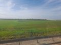
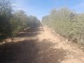
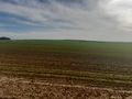
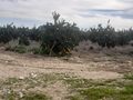
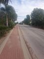
Fields on the way
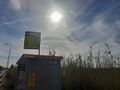
The bus stop I got off at
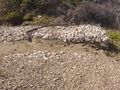
Somebody wrapped a bunch of rocks in a metal fence? What?
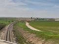
On the bridge over the train tracks. I did not see or hear any trains at any point.
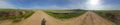
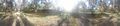
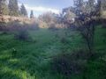
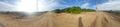
Panorama in the middle of a bunch of fields (not at the point)
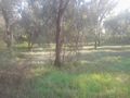
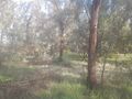
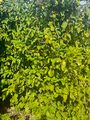
The grove of trees that I walked down while listening to the Dispatch Podcast. I'm not a botanist.
Riverbed
Utterly beautiful.
Panorama inside the riverbed (still not at the point, and before I realized the point would also be in the riverbed)
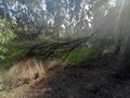
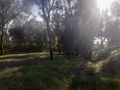
Creepy tree
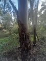
Barkless tree
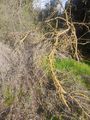
Yellow mold tree
Approaching the point. There was for some reason a large patch of grass covered in filmy dew, where no other grass was even wet

Proof
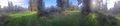
Panorama at the point
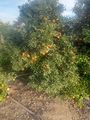
Oranges
and lemons
say the bells of St. Clement's
Orange trees in the middle of the town of Eitan
Combine harvesters
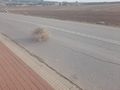
An honest-to-god tumbleweed! Never seen one in real life.


