Difference between revisions of "2024-01-09 32 34"
Yerushalmi (talk | contribs) (Created page with "{{subst:Expedition}}") |
m (Location) |
||
| (One intermediate revision by one other user not shown) | |||
| Line 13: | Line 13: | ||
}}<!-- edit as necessary --> | }}<!-- edit as necessary --> | ||
== Location == | == Location == | ||
| − | + | In an orchard outside the town of Gan Yoshiya. | |
== Participants == | == Participants == | ||
| − | + | [[User:Yerushalmi|Yerushalmi]] ([[User talk:Yerushalmi|talk]]) | |
| − | |||
== Plans == | == Plans == | ||
| − | + | Train to Tel Aviv, train to Netanya, bus to Gan Yoshiya. The field is behind the last row of houses, so I'll need to walk along the street and find a place that I can cut through. | |
== Expedition == | == Expedition == | ||
| − | + | I woke up this morning with two complications right off the bat: First, this pain in my left heel that began yesterday morning and only got worse over the course of the day; and second, both #4 and #5 woke up in the middle of the night and needed me to sit next to them and help them fall asleep again. Thus sleep deprived, I didn't get on the 8:09 train as planned but rather left the house at 9:15. | |
| + | |||
| + | My foot was hurting this morning as well, but not as much as last night. I thought maybe the activity would help, as I had been sitting at home doing computer work and no physical work for the last two days straight. | ||
| + | |||
| + | I reached the train; there was no minyan that late, so I had to daven on my own. Switching trains in Tel Aviv to go to Netanya, and then changing over to the #23 bus when reaching Netanya, went without a hitch. I walked into Gan Yoshiya through the north gate, walked to the south end of the town, and looked for a way past the houses to the fields beyond. There were ''lots'' of dogs, but luckily all of them were fenced in. | ||
| + | |||
| + | Eventually I had to stop someone and ask for advice. The man, briefly amused that I'm going "somewhere random this app sends me every day", said I needed to head eastward, where there would be a gate out of the town to the south. So I headed east; my foot was beginning to hurt again. | ||
| + | |||
| + | I found a small path into the fields long before I reached the gate, and began heading south. A small dog in a front yard, this time unfenced, began barking at me. I opened my backpack and took out a smooth river stone I had picked up in a previous hash and kept for just such a scenario, and kept walking, trying to ignore it. Two more untethered dogs entered the path behind me, also barking - so I picked up another stone from the roadside, just in case. | ||
| + | |||
| + | Luckily I didn't need to use them. The dogs eventually got bored and left. | ||
| − | + | I continued down the path and this time heard barking dogs ''ahead'' of me - several of them. There were about a half dozen, barking like mad, guarding a tent that was completely fenced in (though a previous hash taught me [[2023-12-26_31_35|that's not always reliable]]), barking at me like mad. I gripped my rocks nervously and kept walking past. I don't know what the tent was about; it wasn't in the satellite photo. | |
| − | + | ||
| + | Once past the tent, though, it was easy. I reached the orchard, used the Geohash Droid app to estimate which row of trees I should walk down, got it right on the first try, and reached the point easily. They were avocado trees, which I could tell due to leftover avocados rotting on the ground; I didn't see any on the branches. | ||
| + | |||
| + | The way back was far more difficult. My foot was in a lot of pain and I was limping the whole way. Limp past the dogs, grip my rocks nervously, limp past the other dogs, limp all the way back to the bus stop. I had to stop and rest a few times (during one of which I ate lunch) because I just couldn't walk for the pain. | ||
| + | |||
| + | Train back to Tel Aviv, brief detour to pick up one of my wife's works from an exhibition that just ended, train back to Jerusalem. | ||
== Photos == | == Photos == | ||
| Line 33: | Line 47: | ||
--> | --> | ||
<gallery perrow="5"> | <gallery perrow="5"> | ||
| + | File:Screenshot_20240109_121658_Geohash Droid.jpg | Proof | ||
| + | File:20240109_121708.jpg | Panorama at the point | ||
| + | File:20240109_121819.jpg | Rotting avocados | ||
| + | File:20240109_122537.jpg | Dog guarding the bells of St. Clement's | ||
</gallery> | </gallery> | ||
| − | |||
| − | |||
| − | |||
| − | |||
__NOTOC__ | __NOTOC__ | ||
| − | |||
| − | |||
| − | |||
| − | |||
| − | |||
| − | |||
| − | |||
| − | |||
| − | |||
| − | |||
| − | |||
| − | |||
| − | |||
[[Category:Expeditions]] | [[Category:Expeditions]] | ||
| − | |||
[[Category:Expeditions with photos]] | [[Category:Expeditions with photos]] | ||
| − | |||
| − | |||
| − | |||
| − | |||
| − | |||
[[Category:Coordinates reached]] | [[Category:Coordinates reached]] | ||
| − | + | {{location|IL|M|SH}} | |
| − | |||
| − | |||
| − | |||
| − | |||
| − | |||
| − | |||
| − | |||
| − | |||
| − | |||
| − | |||
| − | |||
| − | |||
| − | |||
| − | |||
| − | |||
| − | |||
| − | |||
Revision as of 15:42, 9 January 2024
| Tue 9 Jan 2024 in 32,34: 32.3447904, 34.9919189 geohashing.info google osm bing/os kml crox |
Location
In an orchard outside the town of Gan Yoshiya.
Participants
Plans
Train to Tel Aviv, train to Netanya, bus to Gan Yoshiya. The field is behind the last row of houses, so I'll need to walk along the street and find a place that I can cut through.
Expedition
I woke up this morning with two complications right off the bat: First, this pain in my left heel that began yesterday morning and only got worse over the course of the day; and second, both #4 and #5 woke up in the middle of the night and needed me to sit next to them and help them fall asleep again. Thus sleep deprived, I didn't get on the 8:09 train as planned but rather left the house at 9:15.
My foot was hurting this morning as well, but not as much as last night. I thought maybe the activity would help, as I had been sitting at home doing computer work and no physical work for the last two days straight.
I reached the train; there was no minyan that late, so I had to daven on my own. Switching trains in Tel Aviv to go to Netanya, and then changing over to the #23 bus when reaching Netanya, went without a hitch. I walked into Gan Yoshiya through the north gate, walked to the south end of the town, and looked for a way past the houses to the fields beyond. There were lots of dogs, but luckily all of them were fenced in.
Eventually I had to stop someone and ask for advice. The man, briefly amused that I'm going "somewhere random this app sends me every day", said I needed to head eastward, where there would be a gate out of the town to the south. So I headed east; my foot was beginning to hurt again.
I found a small path into the fields long before I reached the gate, and began heading south. A small dog in a front yard, this time unfenced, began barking at me. I opened my backpack and took out a smooth river stone I had picked up in a previous hash and kept for just such a scenario, and kept walking, trying to ignore it. Two more untethered dogs entered the path behind me, also barking - so I picked up another stone from the roadside, just in case.
Luckily I didn't need to use them. The dogs eventually got bored and left.
I continued down the path and this time heard barking dogs ahead of me - several of them. There were about a half dozen, barking like mad, guarding a tent that was completely fenced in (though a previous hash taught me that's not always reliable), barking at me like mad. I gripped my rocks nervously and kept walking past. I don't know what the tent was about; it wasn't in the satellite photo.
Once past the tent, though, it was easy. I reached the orchard, used the Geohash Droid app to estimate which row of trees I should walk down, got it right on the first try, and reached the point easily. They were avocado trees, which I could tell due to leftover avocados rotting on the ground; I didn't see any on the branches.
The way back was far more difficult. My foot was in a lot of pain and I was limping the whole way. Limp past the dogs, grip my rocks nervously, limp past the other dogs, limp all the way back to the bus stop. I had to stop and rest a few times (during one of which I ate lunch) because I just couldn't walk for the pain.
Train back to Tel Aviv, brief detour to pick up one of my wife's works from an exhibition that just ended, train back to Jerusalem.
Photos
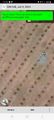
Proof
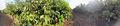
Panorama at the point
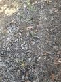
Rotting avocados
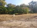
Dog guarding the bells of St. Clement's


