Difference between revisions of "2018-02-24 -38 145"
(Created page with "{{subst:Expedition |lat = -38 |lon = 145 |date = 2018-02-24 }}") |
m (Location) |
||
| (23 intermediate revisions by 2 users not shown) | |||
| Line 14: | Line 14: | ||
== Location == | == Location == | ||
<!-- where you've surveyed the hash to be --> | <!-- where you've surveyed the hash to be --> | ||
| + | This Geohash is located at Lardner Park, an event venue. | ||
== Participants == | == Participants == | ||
<!-- who attended: If you link to your wiki user name in this section, your expedition will be picked up by the various statistics generated for geohashing. You may use three tildes ~ as a shortcut to automatically insert the user signature of the account you are editing with. | <!-- who attended: If you link to your wiki user name in this section, your expedition will be picked up by the various statistics generated for geohashing. You may use three tildes ~ as a shortcut to automatically insert the user signature of the account you are editing with. | ||
--> | --> | ||
| − | + | * [[User:BarbaraTables|BarbaraTables]] | |
| − | |||
| − | |||
== Expedition == | == Expedition == | ||
<!-- how it all turned out. your narrative goes here. --> | <!-- how it all turned out. your narrative goes here. --> | ||
| + | [[Curse of Unawareness]]! On the 24th of February, 2018 (at the age of 15), I attended a Scouting event called [https://web.archive.org/web/20180215035219/https://www.anythinggoes.net.au/ Anything Goes]. Our tent was pitched about 150 meters away from the Geohash (according to a geotagged photo on my phone), and I would have spent the day walking around the site participating in activities. With the Geohash being on the campgrounds and just next to the main path, it is virtually guaranteed I walked somewhere within 0-100m from the Geohash itself that day. In any case, if I had known, I would have taken a picture for the future. | ||
| − | + | I found about this nearly six years later - on the 25th of January, 2024 - by flipping through my old Scout programs and [https://geohashing.info geohashing.info]. If I introduce Geohashing to some fellow Scouts who also attended this and they make an account, I shall generously endow their profile with this unachievement too; spreading this virus like a more personal, targeted version of [[wikipedia:The Game (mind game)|The Game]]. | |
| − | |||
| − | |||
| − | |||
| − | |||
| − | |||
<gallery perrow="5"> | <gallery perrow="5"> | ||
| + | Image:anything_goes_2018-02-24.jpg | A [https://www.facebook.com/photo/?fbid=1595213117260748 photo] containing the Geohash location, taken on the day it appeared. | ||
</gallery> | </gallery> | ||
| Line 38: | Line 34: | ||
{{#vardefine:ribbonwidth|100%}} | {{#vardefine:ribbonwidth|100%}} | ||
<!-- Add any achievement ribbons you earned below, or remove this section --> | <!-- Add any achievement ribbons you earned below, or remove this section --> | ||
| + | {{Curse of Unawareness | ||
| − | + | | latitude = -38 | |
| − | + | | longitude = 145 | |
| − | + | | date = 2018-02-24 | |
| − | [[ | + | | name = [[User:BarbaraTables|BarbaraTables]] |
| − | |||
| − | |||
| − | + | }} | |
| − | |||
| − | |||
| − | |||
| − | + | __NOTOC__ | |
| − | + | [[Category:Not reached - Did not attempt]] | |
| − | + | {{location|AU|VIC|BB}} | |
| − | |||
| − | |||
| − | |||
| − | |||
| − | |||
| − | |||
| − | |||
| − | |||
| − | |||
| − | |||
| − | |||
| − | |||
| − | |||
| − | |||
| − | |||
| − | |||
| − | |||
| − | |||
| − | |||
| − | |||
| − | |||
| − | |||
| − | |||
| − | |||
| − | |||
| − | |||
| − | |||
Latest revision as of 15:05, 29 January 2024
| Sat 24 Feb 2018 in -38,145: -38.2020558, 145.8659392 geohashing.info google osm bing/os kml crox |
Location
This Geohash is located at Lardner Park, an event venue.
Participants
Expedition
Curse of Unawareness! On the 24th of February, 2018 (at the age of 15), I attended a Scouting event called Anything Goes. Our tent was pitched about 150 meters away from the Geohash (according to a geotagged photo on my phone), and I would have spent the day walking around the site participating in activities. With the Geohash being on the campgrounds and just next to the main path, it is virtually guaranteed I walked somewhere within 0-100m from the Geohash itself that day. In any case, if I had known, I would have taken a picture for the future.
I found about this nearly six years later - on the 25th of January, 2024 - by flipping through my old Scout programs and geohashing.info. If I introduce Geohashing to some fellow Scouts who also attended this and they make an account, I shall generously endow their profile with this unachievement too; spreading this virus like a more personal, targeted version of The Game.
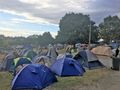
A photo containing the Geohash location, taken on the day it appeared.

Achievements
BarbaraTables earned the Curse of Unawareness Consolation Prize
|