Difference between revisions of "2023-10-14 41 -117"
Michael5000 (talk | contribs) (→Achievements) |
m (per Renaming Proposal) |
||
| (4 intermediate revisions by 2 users not shown) | |||
| Line 13: | Line 13: | ||
}}<!-- edit as necessary --> | }}<!-- edit as necessary --> | ||
== Location == | == Location == | ||
| − | + | In sagebrush off Nevada 293, west of Orovado. | |
== Participants == | == Participants == | ||
[[User:Michael5000|Michael5000]] | [[User:Michael5000|Michael5000]] | ||
| − | == | + | == Expedition == |
| − | + | I hadn't thought too hard about what to do after the eclipse, so after [[2023-10-14 40 -116]] I stopped in Winnemucca to plan the rest of the day. The little shop I randomly picked out turned out to be a new-agey tea and smoothie joint -- no coffee! -- with a lot of "natural healing" rhetoric going on; given Winnemucca's bikers-'n'-casinos reputation, I was pretty darn charmed. | |
| − | + | Refreshed by my naturally-healing tea and smoothy, and having refueled and found coffee at a truckstop 20 miles north of town, I proceeded to tiny Orovada, continued 7 miles west, and took another short hike in sagebrush to the hashpoint. More great scenery, and another graticule pioneered for geohashing! | |
| − | |||
| − | + | I trusted the Nevada State Highway Map, fool that I am, that the gravel road would be a short cut back south to Nevada 140, but it got smaller and smaller and then effectively dead-ended in a rancher's front yard. Something resembling a road continued south, but even with the Expedition Vehicle, it wasn't a road I was willing to travel. So, there was a lot of backtracking. But then, I was geohashing! Backtracking is kind of baked into the enterprise. | |
| − | |||
== Photos == | == Photos == | ||
| − | |||
| − | |||
| − | |||
<gallery perrow="5"> | <gallery perrow="5"> | ||
| + | File:2023-10-14 41 -117 a.jpg|The vehicle at the jump-off point | ||
| + | File:2023-10-14 41 -117 b.jpg|Me, having jumped off and hiked in | ||
| + | File:2023-10-14 41 -117 c.jpg|View to the east | ||
| + | File:2023-10-14 41 -117 d.jpg|View to the west | ||
| + | File:2023-10-14 41 -117 e.jpg|The hashpoint sage plant | ||
| + | File:2023-10-14 41 -117 f.jpg|The location at a broad scale | ||
| + | File:2023-10-14 41 -117 g.jpg|The location at a narrow scale | ||
</gallery> | </gallery> | ||
== Achievements == | == Achievements == | ||
{{#vardefine:ribbonwidth|100%}} | {{#vardefine:ribbonwidth|100%}} | ||
| − | {{ | + | {{Graticule unlocked |
| latitude = 41 | | latitude = 41 | ||
| Line 44: | Line 46: | ||
}} | }} | ||
| − | + | ||
| + | |||
| + | {{Minesweeper geohash | ||
| + | | graticule = [[Jordan Valley, Oregon]] | ||
| + | | ranknumber = 5 | ||
| + | | n = true | ||
| + | | ne = true if graticule to the northeast has been hashed (optional) | ||
| + | | s = true if graticule to the south has been hashed (optional) | ||
| + | | nw = true if graticule to the northwest has been hashed (optional) | ||
| + | | name = [[User:Michael5000|Michael5000]] | ||
| + | }} | ||
| + | {{Minesweeper geohash | ||
| + | | graticule = [[Fields, Oregon]] | ||
| + | | ranknumber = 5 | ||
| + | | n = true | ||
| + | | ne = true if graticule to the northeast has been hashed (optional) | ||
| + | | se = true if graticule to the southeast has been hashed (optional) | ||
| + | | nw = true if graticule to the northwest has been hashed (optional) | ||
| + | | name = [[User:Michael5000|Michael5000]] | ||
| + | }} | ||
__NOTOC__ | __NOTOC__ | ||
| − | |||
| − | |||
| − | |||
| − | |||
| − | |||
| − | |||
| − | |||
| − | |||
| − | |||
| − | |||
| − | |||
| − | |||
| − | |||
[[Category:Expeditions]] | [[Category:Expeditions]] | ||
| − | |||
[[Category:Expeditions with photos]] | [[Category:Expeditions with photos]] | ||
| − | |||
| − | |||
| − | |||
| − | |||
| − | |||
[[Category:Coordinates reached]] | [[Category:Coordinates reached]] | ||
| − | + | {{location|US|NV|HU}} | |
| − | |||
| − | |||
| − | |||
| − | |||
| − | |||
| − | |||
| − | |||
| − | |||
| − | |||
| − | |||
| − | |||
| − | |||
| − | |||
| − | |||
| − | |||
| − | |||
| − | |||
Revision as of 04:38, 20 March 2024
| Sat 14 Oct 2023 in 41,-117: 41.5873906, -117.9453599 geohashing.info google osm bing/os kml crox |
Location
In sagebrush off Nevada 293, west of Orovado.
Participants
Expedition
I hadn't thought too hard about what to do after the eclipse, so after 2023-10-14 40 -116 I stopped in Winnemucca to plan the rest of the day. The little shop I randomly picked out turned out to be a new-agey tea and smoothie joint -- no coffee! -- with a lot of "natural healing" rhetoric going on; given Winnemucca's bikers-'n'-casinos reputation, I was pretty darn charmed.
Refreshed by my naturally-healing tea and smoothy, and having refueled and found coffee at a truckstop 20 miles north of town, I proceeded to tiny Orovada, continued 7 miles west, and took another short hike in sagebrush to the hashpoint. More great scenery, and another graticule pioneered for geohashing!
I trusted the Nevada State Highway Map, fool that I am, that the gravel road would be a short cut back south to Nevada 140, but it got smaller and smaller and then effectively dead-ended in a rancher's front yard. Something resembling a road continued south, but even with the Expedition Vehicle, it wasn't a road I was willing to travel. So, there was a lot of backtracking. But then, I was geohashing! Backtracking is kind of baked into the enterprise.
Photos
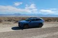
The vehicle at the jump-off point
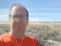
Me, having jumped off and hiked in
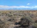
View to the east
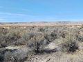
View to the west
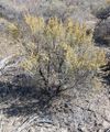
The hashpoint sage plant
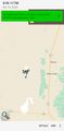
The location at a broad scale

The location at a narrow scale


Achievements
Michael5000 earned the Graticule Unlocked Achievement
|
Michael5000 achieved level 5 of the Minesweeper Geohash achievement
|
Michael5000 achieved level 5 of the Minesweeper Geohash achievement
|