Difference between revisions of "2023-10-08 40 -120"
Michael5000 (talk | contribs) (→Expedition) |
m (per Renaming Proposal) |
||
| (3 intermediate revisions by 2 users not shown) | |||
| Line 13: | Line 13: | ||
}}<!-- edit as necessary --> | }}<!-- edit as necessary --> | ||
== Location == | == Location == | ||
| − | In the forest west of Susanville. | + | In the forest west of Susanville, California. |
== Participants == | == Participants == | ||
| Line 39: | Line 39: | ||
== Achievements == | == Achievements == | ||
{{#vardefine:ribbonwidth|100%}} | {{#vardefine:ribbonwidth|100%}} | ||
| − | |||
| − | + | {{Graticule unlocked | |
| − | |||
| − | |||
| − | |||
| − | + | | latitude = 40 | |
| + | | longitude = -120 | ||
| + | | date = 2023-10-08 | ||
| + | | name = Michael5000 | ||
| − | + | }} | |
| − | + | __NOTOC__ | |
| − | |||
| − | |||
| − | |||
| − | |||
| − | |||
| − | |||
[[Category:Expeditions]] | [[Category:Expeditions]] | ||
| − | |||
[[Category:Expeditions with photos]] | [[Category:Expeditions with photos]] | ||
| − | |||
| − | |||
| − | |||
| − | |||
| − | |||
[[Category:Coordinates reached]] | [[Category:Coordinates reached]] | ||
| − | + | {{location|US|CA|LS}} | |
| − | |||
| − | |||
| − | |||
| − | |||
| − | |||
| − | |||
| − | |||
| − | |||
| − | |||
| − | |||
| − | |||
| − | |||
| − | |||
| − | |||
| − | |||
| − | |||
| − | |||
Revision as of 04:39, 20 March 2024
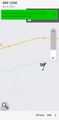
| Sun 8 Oct 2023 in 40,-120: 40.4024858, -120.7353894 geohashing.info google osm bing/os kml crox |
Location
In the forest west of Susanville, California.
Participants
Expedition
I woke up early in Susanville, jumped on my bicycle, and headed for the Bizz Johnson Trail, which follows an old railroad grade through the canyon east of town. There was a lot of activity and parking attendants at the trailhead, but for a running event rather than to accommodate any expected onslaught of geohashers.
It was cold, and I hadn't had any breakfast, so it felt like a long five miles to the bridge where I left the bike. From there, I had a fairly challenging scramble up the canyon wall, step by step, pulling myself along with my arms a lot of the times, and occasionally crawling through the rough bits. Predictably, once I pulled myself over the rim, I found the perfectly convenient and well-marked walking path to the top that I hadn't noticed before. From there, it was just a few minutes strolling through an open fragrant forest to the hashpoint.
It was a bit warmer by the time I was back at the bicycle, and it also turned out that I had been just slightly climbing on the way to the hashpoint, so the ride back to the hotel was quick and triumphant.
Photos
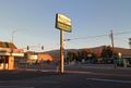
Base Camp: Susanville
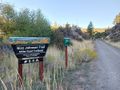
The Bizz Johnson Trail
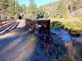
Parking the bike
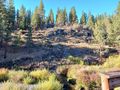
The formidable canyon wall
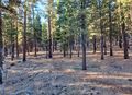
Open forest
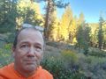
Me at the hashpoint
Voila


Achievements
Michael5000 earned the Graticule Unlocked Achievement
|