Difference between revisions of "2012-09-16 32 35"
imported>LiNaK |
m (per Renaming Proposal) |
||
| (4 intermediate revisions by 3 users not shown) | |||
| Line 1: | Line 1: | ||
| − | |||
| − | |||
| − | |||
| − | |||
| − | |||
| − | |||
| − | |||
| − | |||
| − | |||
{{meetup graticule | {{meetup graticule | ||
| lat=32 | | lat=32 | ||
| Line 40: | Line 31: | ||
<gallery perrow="5"> | <gallery perrow="5"> | ||
Image:Image-2012_09_16_32_35_view.jpg | View from parking | Image:Image-2012_09_16_32_35_view.jpg | View from parking | ||
| + | Image:2012-09-16_32_35_road.jpg | Maoz on his way to the hash | ||
| + | Image:2012-09-16_32_35_view2.jpg | More view along the way | ||
| + | Image:2012-09-16_32_35_proof.jpg | Proof | ||
| + | Image:2012-09-16_32_35_me1.jpg | Omri at the hashpoint | ||
| + | Image:2012-09-16_32_35_marker.jpg | XKCD marker | ||
| + | Image:2012-09-16_32_35_hash.jpg | Hashpoint | ||
| + | Image:2012-09-16_32_35_hash2.jpg | Hashpoint from the other side | ||
| + | Image:2012-09-16_32_35_hash3.jpg | And another | ||
| + | Image:2012-09-16_32_35_hash4.jpg | And yet another | ||
| + | Image:2012-09-16_32_35_wood.jpg | Road in the woods | ||
| + | Image:2012-09-16_32_35_picking.jpg | Picking hyssop | ||
| + | Image:2012-09-16_32_35_pool.jpg | The memorial pool | ||
| + | Image:2012-09-16_32_35_cave.jpg | At Tel Yodfat | ||
| + | Image:2012-09-16_32_35_view3.jpg | View from Tel Yodfat | ||
| + | Image:2012-09-16_32_35_view4.jpg | More view from Tel Yodfat | ||
| + | Image:2012-09-16_32_35_view5.jpg | To the other side... | ||
| + | Image:2012-09-16_32_35_view6.jpg | Squills! | ||
| + | Image:2012-09-16_32_35_squill.jpg | More squills! | ||
| + | Image:2012-09-16_32_35_view7.jpg | And one more view pic | ||
| + | Image:2012-09-16_32_35_me.jpg | Omri with the view | ||
| + | Image:2012-09-16_32_35_dad.jpg | Maoz with the view | ||
</gallery> | </gallery> | ||
| Line 51: | Line 63: | ||
| partner = his dad Maoz | | partner = his dad Maoz | ||
| name = LiNaK | | name = LiNaK | ||
| − | | image = | + | | image = 2012-09-16_32_35_road.jpg |
}} | }} | ||
| − | {{ | + | {{Graticule unlocked |
| latitude = 32 | | latitude = 32 | ||
| longitude = 35 | | longitude = 35 | ||
| date = 2012-09-16 | | date = 2012-09-16 | ||
| name = LiNaK | | name = LiNaK | ||
| − | | image = | + | | image = 2012-09-16_32_35_proof.jpg |
}} | }} | ||
| − | |||
| − | |||
| − | |||
| − | |||
| − | |||
| − | |||
| − | |||
| − | |||
| − | |||
| − | |||
[[Category:Expeditions]] | [[Category:Expeditions]] | ||
| − | |||
[[Category:Expeditions with photos]] | [[Category:Expeditions with photos]] | ||
| − | |||
| − | |||
| − | |||
| − | |||
| − | |||
[[Category:Coordinates reached]] | [[Category:Coordinates reached]] | ||
| − | + | {{location|IL|Z|AK}} | |
| − | |||
| − | |||
| − | |||
| − | |||
| − | |||
| − | |||
| − | |||
| − | |||
| − | |||
| − | |||
| − | |||
| − | |||
| − | |||
| − | |||
| − | |||
| − | |||
| − | |||
Latest revision as of 05:31, 20 March 2024
| Sun 16 Sep 2012 in 32,35: 32.8753873, 35.2573592 geohashing.info google osm bing/os kml crox |
Location
Forest Segev, between the villages of Yuvalim and Ya'ad, a few kilometers from the city of Sakhnin, Lower Galilee region.
Participants
Maoz, my dad.
Plans
On the evening of the 15th I've suggested my parents that we could use the Rosh HaShanah holiday for a family trip up north to the green Galilee, to where "incidentally" the hash was today. We could have a nice walk at the forest and try and find the hash on the way. Eventually it was just my dad that was willing to try out that "weird new game of yours".
Expedition
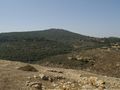
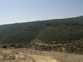
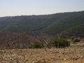
Hitting the road on 7:30 am, so to avoid the ridiculous traffic jams of Rosh HaShanah's eve, the two of us drove up to the parking lot near Ya'ad, listening to the holiday radio programs on the way. The car could reach until the entrance to the entrance of a dirt road dirt where we parked and continued by foot. That part of the wood was very generously reticulated by roads, but non of them appeared on the map so we got a chance to wander a little around that very green and beautiful area and enjoy the views of the surrounding mountains (or maybe the right terminology is hills, as this area isn't actually that high).
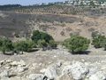
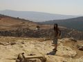
After finding the correct spot somewhere right next to one of the small hiking roads (and leaving a great XKCD mark for following visitors) we headed out to see if there were any other cool things to see around the area. Maoz used his scouting knowledge for finding patches of hyssop, birch and all sorts of other leaves good for cooking or tea to take home (the hyssop actually proved useful right when arriving home for a special touch to our pasta lunch). A small memorial pond we saw in a book about the area was found by us just a few minutes walk from the parking place, but was smaller than seen in the book and not suitable for swimming.
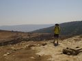
Because making the whole drive up north for just the two hours we've already spent felt kind of silly, we took another detour before returning home and visited the archaeological site of Tel Yodfat. A little bit of history- the place was one of the main areas of fighting during the Jewish rebellion against the Romans around 66 AD and the historical village that once sat there was used as a base for the rebels and was destroyed by the Roman army when they recaptured it. We made the small climb to the head of the hill from where one can get a view of the Lower Galilee area. We would ave loved to stay there even more and explore other things at the area, but time was ticking and we made our way back home, still having the holiday dinner to get to on the evening before the traffic jams start. Shanah Tova...
Photos
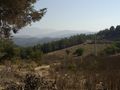
View from parking
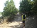
Maoz on his way to the hash
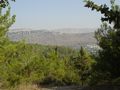
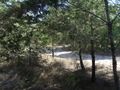
More view along the way
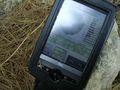
Proof
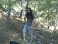
Omri at the hashpoint

XKCD marker

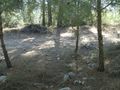
Hashpoint
Hashpoint from the other side
And another
And yet another
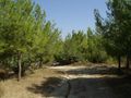
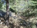
Road in the woods
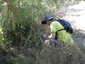
Picking hyssop
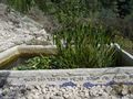
The memorial pool
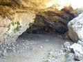
At Tel Yodfat
View from Tel Yodfat
More view from Tel Yodfat

To the other side...
Squills!
More squills!
And one more view pic
Omri with the view
Maoz with the view


Achievements
LiNaK earned the Drag-along achievement
|
LiNaK earned the Graticule Unlocked Achievement
|