Difference between revisions of "2010-10-27 38 -108"
imported>Messyhair42 |
m (per Renaming Proposal) |
||
| (5 intermediate revisions by 3 users not shown) | |||
| Line 5: | Line 5: | ||
}} | }} | ||
| − | + | ||
__NOTOC__ | __NOTOC__ | ||
== Location == | == Location == | ||
| + | Left Lane of U.S. Highway 50 westbound, about 20 miles outside of Grand Junction. | ||
| − | |||
== Participants == | == Participants == | ||
| − | |||
* [[user:Messyhair42|MessyHair42]] | * [[user:Messyhair42|MessyHair42]] | ||
== Plans == | == Plans == | ||
| + | The location for my home graticule was no good, so I decided to take a trip to the Delta graticule, just south of my home graticule. It happened to be in the left lane of U.S. Highway 50 westbound, about 20 miles outside of Grand Junction. | ||
| − | to go after work | + | Plan to go after work. |
== Expedition == | == Expedition == | ||
| − | I got off work early ~7:40 and drove out towards Delta, made a U-turn after | + | I got off work early (~7:40) and drove out towards Delta, and made a U-turn after I had passed the hashpoint, got up to speed and passed through the point for a Speed Racer achievement. |
| + | |||
| + | I did not have my camera and my only GPS is my phone with the Geohash Droid App, and I'm not | ||
| + | sure if I can get a tracklog from it. | ||
| + | |||
| + | However, I did manage to snap a picture of my speedometer. Also, because of the way I left work for the hashpoint, it could be called a [[Tron achievement]], but I can not provide sufficient proof for that. | ||
| + | also could have been a deja vu achievement; I was in Delta the previous Sunday for a wedding and passed through this exact point, but proof of a road trip is hard to come by. | ||
== Photos == | == Photos == | ||
| − | + | ||
| + | <gallery> | ||
| + | Image:2010-10-27 20-13-58 888r.jpg|The speedometer | ||
| + | </gallery> | ||
| + | |||
== Achievements == | == Achievements == | ||
| − | {{ | + | * Land Geohash |
| + | |||
| + | {{Graticule unlocked | ||
| latitude = 38 | | latitude = 38 | ||
| Line 44: | Line 56: | ||
| date = 2010-10-27 | | date = 2010-10-27 | ||
| name = [[User:Messyhair42]] | | name = [[User:Messyhair42]] | ||
| − | |||
| speed = 70, even though the highway says 65 | | speed = 70, even though the highway says 65 | ||
| Line 51: | Line 62: | ||
{{Minesweeper geohash | {{Minesweeper geohash | ||
| − | | graticule = | + | | graticule = Grand_Junction,_Colorado |
| ranknumber = 1 | | ranknumber = 1 | ||
| − | | s = true | + | | s = true |
| name = [[User:Messyhair42]] | | name = [[User:Messyhair42]] | ||
}} | }} | ||
| + | |||
| + | [[Category:Expeditions]] | ||
| + | [[Category:Coordinates reached]] | ||
| + | {{location|US|CO|DT}} | ||
Latest revision as of 06:00, 20 March 2024
| Wed 27 Oct 2010 in 38,-108: 38.8220939, -108.2969168 geohashing.info google osm bing/os kml crox |
Location
Left Lane of U.S. Highway 50 westbound, about 20 miles outside of Grand Junction.
Participants
Plans
The location for my home graticule was no good, so I decided to take a trip to the Delta graticule, just south of my home graticule. It happened to be in the left lane of U.S. Highway 50 westbound, about 20 miles outside of Grand Junction.
Plan to go after work.
Expedition
I got off work early (~7:40) and drove out towards Delta, and made a U-turn after I had passed the hashpoint, got up to speed and passed through the point for a Speed Racer achievement.
I did not have my camera and my only GPS is my phone with the Geohash Droid App, and I'm not sure if I can get a tracklog from it.
However, I did manage to snap a picture of my speedometer. Also, because of the way I left work for the hashpoint, it could be called a Tron achievement, but I can not provide sufficient proof for that. also could have been a deja vu achievement; I was in Delta the previous Sunday for a wedding and passed through this exact point, but proof of a road trip is hard to come by.
Photos
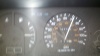
The speedometer

Achievements
- Land Geohash
User:Messyhair42 earned the Graticule Unlocked Achievement
|

User:Messyhair42 achieved level 1 of the Minesweeper Geohash achievement
|