Difference between revisions of "2008-06-12 47 19"
From Geohashing
imported>Tomtom m |
m (per Renaming Proposal) |
||
| (4 intermediate revisions by 4 users not shown) | |||
| Line 1: | Line 1: | ||
{{meetup graticule | {{meetup graticule | ||
| − | |||
| lat=47 | | lat=47 | ||
| lon=19 | | lon=19 | ||
| Line 31: | Line 30: | ||
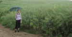
Image:tom.jpg|Tom on the approach | Image:tom.jpg|Tom on the approach | ||
Image:dem1.jpg|Dem at the site | Image:dem1.jpg|Dem at the site | ||
| − | Image: | + | Image:2008-06-12_47_19_hashlocation.jpg|the geohash site |
</gallery> | </gallery> | ||
| + | |||
| + | ==Achievements== | ||
| + | {{Graticule unlocked | latitude = 47 | longitude = 19 | date = 2008-06-12 | name = [[User:Dem|Dem]] and [[User:Tomtom|Tom]]}} | ||
| + | {{Land geohash | latitude = 47 | longitude = 19 | date = 2008-06-12 | name = [[User:Dem|Dem]] and [[User:Tomtom|Tom]]}} | ||
[[Category:Expeditions]] | [[Category:Expeditions]] | ||
| − | [[Category: | + | [[Category:Expeditions with photos]] |
| + | [[Category:Coordinates reached]] | ||
| + | {{location|HU|PE}} | ||
Latest revision as of 07:41, 20 March 2024
| Thu 12 Jun 2008 in Budapest, Hungary: 47.7906706, 19.3355328 geohashing.info google osm bing/os kml crox |
| Date | Coordinates |
|---|---|
| Thu 12 Jun 2008 | 47.7906706, 19.3355328 |
FIRST EVER GEOHASH EXPEDITION IN HUNGARY!
Contents
Location
The hashpoint for the graticule was near Vác, between the villages called Csővár and Püspökhatvan, outside residental areas, in a valley amongst pretty slopes of wheat fields, close to a beautiful lake.
Expedition
Train journey to Vác, 15 mins hitchike to Csővár (thank you guys) plus some 30 mins hiking. Me and Tom (probably the only two geohashers in Hungary) accessed the place despite the heavy rain and returned home with soggy socks and massive amount of mud stuck to our shoes.
Pictures
- the world famous muddy-shoes-and-soaked-trousers party
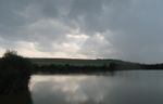
the lake nearby after the rain

clouds and rays
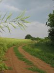
the road to the site
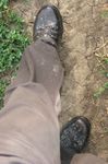
getting dirty
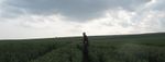
Tom on the approach
Dem at the site
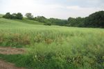
the geohash site


Achievements
Dem and Tom earned the Graticule Unlocked Achievement
|
Dem and Tom earned the Land geohash achievement
|