Difference between revisions of "2010-07-18 45 -122"
imported>Jiml (Expand Template) |
m (per Renaming Proposal) |
||
| (12 intermediate revisions by 4 users not shown) | |||
| Line 1: | Line 1: | ||
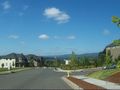
| + | [[Image:2010-07-18_45_-122-area1.jpg|thumb|left|300px|Suburban east Vancouver.]] | ||
| − | |||
| − | |||
| − | |||
| − | |||
| − | |||
| − | |||
{{meetup graticule | {{meetup graticule | ||
| lat=45 | | lat=45 | ||
| Line 12: | Line 7: | ||
}} | }} | ||
| − | + | ||
__NOTOC__ | __NOTOC__ | ||
== Location == | == Location == | ||
| − | + | Adjacent to a set of new houses near Camas, Washington | |
== Participants == | == Participants == | ||
| − | + | ||
| + | * [[User:Jiml|Jim]] | ||
| + | * [[User:Michael5000|Michael5000]] | ||
== Plans == | == Plans == | ||
| − | + | Jim's headed to the blood bank around noon, so he'll probably be able to | |
| + | get to the hashpoint around 3, depending on how much grief he gets | ||
| + | from the I-205 bridge construction. I'm thinking of crossing over | ||
| + | the Columbia on I-5, then going east on some road to get to the Camas area. | ||
| + | |||
| + | |||
| + | == Expeditions == | ||
| + | |||
| + | ===Expedition One=== | ||
| + | Michael5000 tried a second straight day of non-motorized geohashing expeditions. It was a 33-mile round trip on the bicycle, easily the longest ride so far this year. The actual hashpoint, though, was in an awkward position, in a rocky bramble patch uphill from, and clearly visible from, the backyards of a new residential development. | ||
| + | |||
| + | I made a cursory attempt to reach it, but it looked like it would not only be a miserable slog, but would probably make the natives nervous. In fact, a native came up the street after my abortive attempt to ask if I "was looking for something back there," his grammar offering assistance but his tone radiating suspicion. To preserve my dignity, I implied that I had just been looking for someplace to pee. | ||
| + | |||
| + | Technically, it was a thwarted expedition, but in terms of the reasons I started geohashing -- a provocation to exploration, fitness, and getting out of the usual routine -- it was one of the most successful hashes to date. | ||
| + | |||
| + | ===Expedition Two=== | ||
| + | Ah ha! I had looked earlier and not seen any evidence that Michael5000 was going to try | ||
| + | for this hash, so when the (adjacent) homeowner reported that someone else was looking at | ||
| + | that same area, I thought "Ninja??" The answer is "No, just Michael5000." | ||
| − | + | So, I set out for the hashpoint from the Red Cross, and the traffic was really slow headed north | |
| − | + | for reasons that were unclear to me. Once I finally made it to the bridge, it cleared up. Maybe | |
| + | everyone else was trying to avoid the I-205 bridge. | ||
| + | I headed east on Washington route 14 and soon passed I-205, along with signs that translated to me | ||
| + | as "Don't even think of going Southbound on I-205 from here". I headed into a small | ||
| + | development, and eventually the GPS got down to a few hundred feet. I got out and walked back towards | ||
| + | the undeveloped area. I talked to the adjacent homeowner, and they said it was fine for me | ||
| + | to skirt around their fence to try to get to the hashpoint. However, the back corner of their | ||
| + | fence was still 60 feet away, and after the first 10 of those feet, it turned into a wall of | ||
| + | blackberry. | ||
| + | |||
| + | I returned to my car, and switched to my hiking boots and attempted to reach the hashpoint from the | ||
| + | "back" side. The only thing that I accomplished was that ripping open the back of my hand | ||
| + | in a battle with the velociraptors. | ||
| + | Luckily, I still seemed to have enough platelets left so that I was still able to | ||
| + | clot the wound, but I decided I'd lost enough blood factors for the day and | ||
| + | that tearing my way through blackberry and fighting Velociraptors didn't meet the | ||
| + | Blood Bank's admonishment against any "heavy exercising or lifting" for 5 hours. | ||
| + | |||
| + | I tried again from the | ||
| + | front end, and plunged in 8 feet, took pictures, and retreated to head home. Traffic wasn't as bad | ||
| + | in this direction, and those at home were happy to see me, but I'm pretty sure that throwing the | ||
| + | tennis ball continuously for hours wasn't what the Red Cross had in mind either. | ||
| + | |||
| + | |||
| + | |||
| + | <!-- Nothing here yet.... > | ||
== Tracklog == | == Tracklog == | ||
<!-- if your GPS device keeps a log, you may post a link here --> | <!-- if your GPS device keeps a log, you may post a link here --> | ||
| + | |||
== Photos == | == Photos == | ||
| − | + | ||
| − | |||
| − | |||
<gallery perrow="5"> | <gallery perrow="5"> | ||
| + | Image:2010-07-18_45_-122-area1.jpg | View of the area | ||
| + | Image:2010-07-18_45_-122-alley.jpg | The path along the fence | ||
| + | |||
| + | Image:2010-07-18_45_-122-area2.jpg | View of the area | ||
| + | Image:2010-07-18_45_-122-blackberry.jpg | The wall of blackberry protecting the hashpoint | ||
| + | Image:2010-07-18_45_-122-gps.jpg | How close we got | ||
| + | Image:2010-07-18_45_-122-hashpt2.jpg | Close up of the direction we needed to go | ||
| + | Image:2010-07-18_45_-122-raptor.jpg | Claw damage to Jim's hand | ||
| + | |||
| + | File:2010-07-18 45 -122 leaving PDX.JPG | The I-205 Bridge from M5K's crossing | ||
| + | File:2010-07-18 45 -122 approximately the hashpoint.JPG | M5K glimpses the hashpoint area. cf. Jim's "The path along the fence" for evidence of the consistency of human experience. | ||
| + | |||
</gallery> | </gallery> | ||
== Achievements == | == Achievements == | ||
{{#vardefine:ribbonwidth|800px}} | {{#vardefine:ribbonwidth|800px}} | ||
| − | |||
| + | {{done with nature | ||
| − | + | | latitude = 45 | |
| − | + | | longitude = -122 | |
| − | + | | date = 2010-07-18 | |
| + | | name = Jim & Michael5000 | ||
| + | | image = 2010-07-18_45_-122-alley.jpg | ||
| − | + | }} | |
| − | + | [[Category:Expeditions]] | |
| − | [[Category: | ||
| − | |||
| − | |||
| − | |||
| − | |||
[[Category:Expeditions with photos]] | [[Category:Expeditions with photos]] | ||
| − | |||
| − | |||
| − | |||
| − | |||
| − | |||
| − | |||
| − | |||
| − | |||
| − | |||
[[Category:Coordinates not reached]] | [[Category:Coordinates not reached]] | ||
| − | |||
[[Category:Not reached - Mother Nature]] | [[Category:Not reached - Mother Nature]] | ||
[[Category:Not reached - No public access]] | [[Category:Not reached - No public access]] | ||
| − | + | {{location|US|WA|CR}} | |
| − | |||
| − | |||
Latest revision as of 14:40, 2 April 2024

| Sun 18 Jul 2010 in 45,-122: 45.5965541, -122.4474678 geohashing.info google osm bing/os kml crox |
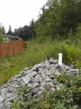
Location
Adjacent to a set of new houses near Camas, Washington
Participants
Plans
Jim's headed to the blood bank around noon, so he'll probably be able to get to the hashpoint around 3, depending on how much grief he gets from the I-205 bridge construction. I'm thinking of crossing over the Columbia on I-5, then going east on some road to get to the Camas area.
Expeditions
Expedition One
Michael5000 tried a second straight day of non-motorized geohashing expeditions. It was a 33-mile round trip on the bicycle, easily the longest ride so far this year. The actual hashpoint, though, was in an awkward position, in a rocky bramble patch uphill from, and clearly visible from, the backyards of a new residential development.
I made a cursory attempt to reach it, but it looked like it would not only be a miserable slog, but would probably make the natives nervous. In fact, a native came up the street after my abortive attempt to ask if I "was looking for something back there," his grammar offering assistance but his tone radiating suspicion. To preserve my dignity, I implied that I had just been looking for someplace to pee.
Technically, it was a thwarted expedition, but in terms of the reasons I started geohashing -- a provocation to exploration, fitness, and getting out of the usual routine -- it was one of the most successful hashes to date.
Expedition Two
Ah ha! I had looked earlier and not seen any evidence that Michael5000 was going to try for this hash, so when the (adjacent) homeowner reported that someone else was looking at that same area, I thought "Ninja??" The answer is "No, just Michael5000."
So, I set out for the hashpoint from the Red Cross, and the traffic was really slow headed north for reasons that were unclear to me. Once I finally made it to the bridge, it cleared up. Maybe everyone else was trying to avoid the I-205 bridge.
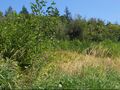
I headed east on Washington route 14 and soon passed I-205, along with signs that translated to me as "Don't even think of going Southbound on I-205 from here". I headed into a small development, and eventually the GPS got down to a few hundred feet. I got out and walked back towards the undeveloped area. I talked to the adjacent homeowner, and they said it was fine for me to skirt around their fence to try to get to the hashpoint. However, the back corner of their fence was still 60 feet away, and after the first 10 of those feet, it turned into a wall of blackberry.
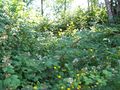
I returned to my car, and switched to my hiking boots and attempted to reach the hashpoint from the "back" side. The only thing that I accomplished was that ripping open the back of my hand in a battle with the velociraptors. Luckily, I still seemed to have enough platelets left so that I was still able to clot the wound, but I decided I'd lost enough blood factors for the day and that tearing my way through blackberry and fighting Velociraptors didn't meet the Blood Bank's admonishment against any "heavy exercising or lifting" for 5 hours.
I tried again from the front end, and plunged in 8 feet, took pictures, and retreated to head home. Traffic wasn't as bad in this direction, and those at home were happy to see me, but I'm pretty sure that throwing the tennis ball continuously for hours wasn't what the Red Cross had in mind either.
Photos
View of the area
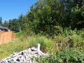
The path along the fence
View of the area
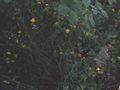
The wall of blackberry protecting the hashpoint
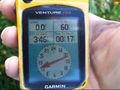
How close we got
Close up of the direction we needed to go
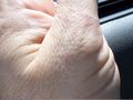
Claw damage to Jim's hand
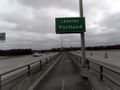
The I-205 Bridge from M5K's crossing
M5K glimpses the hashpoint area. cf. Jim's "The path along the fence" for evidence of the consistency of human experience.


Achievements
Jim & Michael5000 earned the Done with Nature consolation prize
|