Difference between revisions of "2024-02-11 47 -122"
Coyotebush (talk | contribs) ([live picture]Bus picking me off [https://openstreetmap.org/?mlat=47.57937778&mlon=-122.32888056&zoom=16 @47.5794,-122.3289]) |
Coyotebush (talk | contribs) m (fix various directions) |
||
| (13 intermediate revisions by 2 users not shown) | |||
| Line 16: | Line 16: | ||
== Location == | == Location == | ||
<!-- where you've surveyed the hash to be --> | <!-- where you've surveyed the hash to be --> | ||
| − | + | Right next to an apartment building in the Greenbridge development, about three blocks outside the Seattle city limits. | |
== Participants == | == Participants == | ||
| Line 29: | Line 29: | ||
== Expedition == | == Expedition == | ||
<!-- how it all turned out. your narrative goes here. --> | <!-- how it all turned out. your narrative goes here. --> | ||
| + | The early morning was rainy, but by late morning it was more windy than anything. Several bus routes intersect at SW Roxbury St (the city limit) and 8th Ave SW; I selected a travel plan with the shortest bus ride, which turned out to mean taking route 131 from near the [[wikipedia:SODO station (Sound Transit)|SODO light rail station]] rather than from downtown. | ||
| + | *Waiting for the 131 bus -- [[User:Coyotebush|Coyotebush]] ([[User talk:Coyotebush|talk]]) [https://openstreetmap.org/?mlat=47.57942109&mlon=-122.32923878&zoom=16 @47.5794,-122.3292] 11:43, 11 February 2024 (PST) | ||
| + | |||
| + | The bus stop was within 100 meters of the point, and I ascended a flight of stairs to 8th Pl SW, really a mid-block parking lot also providing entrances to upper-floor apartments. Soon I realized that these entrances had more substantial porches between the sidewalk and building than expected - perhaps I had mistakenly looked at the other side of the building. | ||
| + | |||
| + | The point seemed to be between the porches of units 202 and 203, and behind a large tree. I considered how to get satisfactorily close without causing concern. Presently a car parked nearby; I waited for a while, then the occupants entered unit 201. Could have engaged with them. Eventually I popped up to 203's porch for a minute then scurried away. | ||
| + | |||
| + | The cafe around the corner had just a few other patrons and offered me a brunch menu. I ate a delicious eggs benedict with a view of arriving airplanes - quickly, in time for the next northbound bus. | ||
| + | |||
| + | Took a few more photos and retraced the same journey back home, with occasional sun in the sky. | ||
| − | |||
| − | |||
| − | |||
== Photos == | == Photos == | ||
| Line 40: | Line 47: | ||
--> | --> | ||
<gallery perrow="5"> | <gallery perrow="5"> | ||
| + | Image:2024-02-11_47_-122_coyotebush_1707701112261.jpg|Bus picking me up [https://openstreetmap.org/?mlat=47.57937778&mlon=-122.32888056&zoom=16 @47.5794,-122.3289] | ||
| + | |||
| + | Image:2024-02-11_47_-122_coyotebush_1707701238580.jpg|Bus dropping me off | ||
| + | |||
| + | Image:2024-02-11_47_-122_coyotebush_1707701271804.jpg|Porches of 201, 202, and 203 [https://openstreetmap.org/?mlat=47.51476944&mlon=-122.34573056&zoom=16 @47.5148,-122.3457] | ||
| + | |||
| + | Image:2024-02-11_47_-122_coyotebush_1707701295383.jpg|Geohasher [https://openstreetmap.org/?mlat=47.51476944&mlon=-122.34573056&zoom=16 @47.5148,-122.3457] | ||
| + | |||
| + | Image:2024-02-11_47_-122_coyotebush_1707702467029.jpg|Map | ||
Image:2024-02-11_47_-122_coyotebush_1707684020892.jpg|Brunch after [https://openstreetmap.org/?mlat=47.51452650&mlon=-122.34544127&zoom=16 @47.5145,-122.3454] | Image:2024-02-11_47_-122_coyotebush_1707684020892.jpg|Brunch after [https://openstreetmap.org/?mlat=47.51452650&mlon=-122.34544127&zoom=16 @47.5145,-122.3454] | ||
| − | Image:2024-02-11_47_- | + | Image:2024-02-11_47_-122_coyotebush_1707701425945.jpg|Cafe below clock, point behind building on the right [https://openstreetmap.org/?mlat=47.51449167&mlon=-122.34496389&zoom=16 @47.5145,-122.3450] |
| + | |||
| + | Image:2024-02-11_47_-122_coyotebush_1707701518273.jpg|Plaza panorama | ||
| + | |||
| + | Image:2024-02-11_47_-122_coyotebush_1707701464029.jpg|Light rail taking me home [https://openstreetmap.org/?mlat=47.58107222&mlon=-122.32730278&zoom=16 @47.5811,-122.3273] | ||
| + | |||
| + | |||
</gallery> | </gallery> | ||
| Line 50: | Line 72: | ||
<!-- Add any achievement ribbons you earned below, or remove this section --> | <!-- Add any achievement ribbons you earned below, or remove this section --> | ||
| + | {{Public transport geohash | latitude = 47 | longitude = -122 | date = 2024-02-11 | name = coyotebush | image = 2024-02-11_47_-122_coyotebush_1707701112261.jpg }} | ||
| + | |||
| + | {{consecutive geohash | count = 2 | latitude = 47 | longitude = -122 | date = 2024-02-10 | name = coyotebush }} | ||
__NOTOC__ | __NOTOC__ | ||
| − | |||
| − | |||
| − | |||
| − | |||
| − | |||
| − | |||
| − | |||
| − | |||
| − | |||
| − | |||
| − | |||
| − | |||
| − | |||
[[Category:Expeditions]] | [[Category:Expeditions]] | ||
| − | |||
[[Category:Expeditions with photos]] | [[Category:Expeditions with photos]] | ||
| − | |||
| − | |||
| − | |||
| − | |||
| − | |||
[[Category:Coordinates reached]] | [[Category:Coordinates reached]] | ||
| − | + | {{location|US|WA|KN}} | |
| − | |||
| − | |||
| − | |||
| − | |||
| − | |||
| − | |||
| − | |||
| − | |||
| − | |||
| − | |||
| − | |||
| − | |||
| − | |||
| − | |||
| − | |||
| − | |||
| − | |||
Latest revision as of 18:38, 10 May 2024
| Sun 11 Feb 2024 in Seattle: 47.5149618, -122.3456463 geohashing.info google osm bing/os kml crox |
Location
Right next to an apartment building in the Greenbridge development, about three blocks outside the Seattle city limits.
Participants
Plans
It's a bit far and likely to be wet, so I'd most probably go by transit. GreenBridge Cafe, 50 meters away, sounds excellent - perhaps that's lunch. Coyotebush (talk)
Expedition
The early morning was rainy, but by late morning it was more windy than anything. Several bus routes intersect at SW Roxbury St (the city limit) and 8th Ave SW; I selected a travel plan with the shortest bus ride, which turned out to mean taking route 131 from near the SODO light rail station rather than from downtown.
- Waiting for the 131 bus -- Coyotebush (talk) @47.5794,-122.3292 11:43, 11 February 2024 (PST)
The bus stop was within 100 meters of the point, and I ascended a flight of stairs to 8th Pl SW, really a mid-block parking lot also providing entrances to upper-floor apartments. Soon I realized that these entrances had more substantial porches between the sidewalk and building than expected - perhaps I had mistakenly looked at the other side of the building.
The point seemed to be between the porches of units 202 and 203, and behind a large tree. I considered how to get satisfactorily close without causing concern. Presently a car parked nearby; I waited for a while, then the occupants entered unit 201. Could have engaged with them. Eventually I popped up to 203's porch for a minute then scurried away.
The cafe around the corner had just a few other patrons and offered me a brunch menu. I ate a delicious eggs benedict with a view of arriving airplanes - quickly, in time for the next northbound bus.
Took a few more photos and retraced the same journey back home, with occasional sun in the sky.
Photos
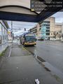
Bus picking me up @47.5794,-122.3289
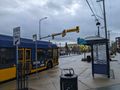
Bus dropping me off

Porches of 201, 202, and 203 @47.5148,-122.3457
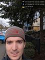
Geohasher @47.5148,-122.3457
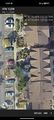
Map
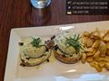
Brunch after @47.5145,-122.3454

Cafe below clock, point behind building on the right @47.5145,-122.3450

Plaza panorama

Light rail taking me home @47.5811,-122.3273


Achievements
coyotebush earned the Public transport geohash achievement
|
coyotebush earned the Consecutive geohash achievement
|