Difference between revisions of "2024-05-13 43 -124"
Michael5000 (talk | contribs) (→Achievements) |
Michael5000 (talk | contribs) |
||
| (One intermediate revision by the same user not shown) | |||
| Line 26: | Line 26: | ||
== Photos == | == Photos == | ||
| − | + | ||
| − | |||
| − | |||
<gallery perrow="5"> | <gallery perrow="5"> | ||
| + | File:2024-05-13 43 -124 a.jpg|View from the hashpoint | ||
| + | File:2024-05-13 43 -124 b.jpg|Me at the hashpoint | ||
| + | File:2024-05-13 43 -124 c.jpg|Along the trail | ||
| + | File:2024-05-13 43 -124 d.jpg|The bridge! | ||
| + | File:2024-05-13 43 -124 e.jpg| | ||
</gallery> | </gallery> | ||
| Line 38: | Line 41: | ||
__NOTOC__ | __NOTOC__ | ||
| − | |||
| − | |||
| − | |||
| − | |||
| − | |||
| − | |||
| − | |||
| − | |||
| − | |||
| − | |||
[[Category:Expeditions]] | [[Category:Expeditions]] | ||
| − | |||
[[Category:Expeditions with photos]] | [[Category:Expeditions with photos]] | ||
| − | |||
| − | |||
| − | |||
| − | |||
[[Category:Coordinates reached]] | [[Category:Coordinates reached]] | ||
| − | |||
| − | |||
| − | |||
| − | |||
| − | |||
| − | |||
| − | |||
| − | |||
| − | |||
| − | |||
| − | |||
| − | |||
| − | |||
| − | |||
Revision as of 04:35, 14 May 2024
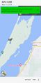
| Mon 13 May 2024 in 43,-124: 43.3948827, -124.3071556 geohashing.info google osm bing/os kml crox |
Location
On the North Spit of Coos Bay.
Participants
Expedition
Having conducted some business in North Bend, I drove over the McCullough Bridge and then out across the causeway that leads to the North Spit area. On the map, it looked like a road would lead to within a hop, skip, and jump of the hashpoint, but I didn't really do my homework on that point -- that "road" is really just part of a network of dune trails, I think.
I parked at the end of Trans-Pacific Lane, about 1.7 kilometers from the hashpoint, and started into the trail network. I wanted to go pretty much straight west, though, and all of the trails wanted to go south by southwest, and I had a hard time making much progress. Finally, I decided to try for a straight shot through the forest, but that wasn't as easy as it look and I soon got pretty disoriented. At this point I had been walking for quite a while, so when I found the trail again, I decided to call it a day.
Then, naturally, I found a side trail I had missed before, and it turned out that, after another kilometer or so of walking, it got me to within a hop, skip, and jump of the hashpoint. And there I was!
Photos
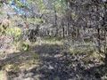
View from the hashpoint
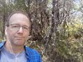
Me at the hashpoint
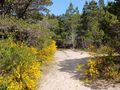
Along the trail
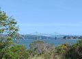
The bridge!


Achievements
- First expedition to Coos County and the Coos Bay graticule since 2010.