Difference between revisions of "2018-06-05 51 6"
(Create expedition page) |
m (subst-ing) |
||
| (5 intermediate revisions by 2 users not shown) | |||
| Line 1: | Line 1: | ||
| − | + | [[Image:{{{image|2018-06-05 51 6 pah 010.jpg}}}|thumb|right]] | |
| − | + | {{meetup graticule | |
| − | [[Image:{{{image| | + | | lat=51 |
| − | + | | lon=6 | |
| − | + | | date=2018-06-05 | |
| − | + | }} | |
| − | |||
| − | |||
| − | |||
| − | | lat= | ||
| − | | lon= | ||
| − | | date= | ||
| − | }} | ||
__NOTOC__ | __NOTOC__ | ||
== Location == | == Location == | ||
| − | + | Right next to a lake close to [[wikipedia: Duisburg-Entenfang_station|Duisburg-Entenfang]]. | |
== Participants == | == Participants == | ||
| − | + | * [[User:Pah|pah]] [[File:U+110DB.png|middle|6px|link=User:Pah]] ([[2018-05-21 50 7|prev]]|[[1977-10-19 48 11|next]]) | |
| − | -- | ||
| − | == | + | == Expedition == |
| − | |||
| − | + | On a nice summer evening, pah noticed that the today’s hash was only 200m away from an easy to reach [[wikipedia:Duisburg-Entenfang_station|train station]]. He quickly jumped on the next tram, took an “S-Bahn” to Duisburg and then the [[wikipedia: Troisdorf–Mülheim-Speldorf_railway |RB37 (Der Wedauer)]] to [[wikipedia:Duisburg-Entenfang_station|Duisburg Entenfang]], where he arrived around one hour later. | |
| − | + | ||
| + | During the remaining 200m of walking, pah realized how close the hash was located to the lake ''Entenfang''. It took about 20 minutes of hash dancing - always scarily close to the water - until he caught a reasonably well GPS lock. And yes, the “proof” picture was taken less than the '''one''' meter away from the shore, which the GPS still reports as a distance. You have to trust me, that the jumping GPS coordinates never actually led him '''into''' the water, though. | ||
| − | + | Lucky to have reached the hash with dry feet, pah took some pictures and went back by train to Düsseldorf via Duisburg again. | |
| − | |||
== Photos == | == Photos == | ||
| − | |||
| − | |||
| − | |||
<gallery perrow="5"> | <gallery perrow="5"> | ||
| + | Image:2018-06-05 51 6 pah 001.png | Trip schedule | ||
| + | Image:2018-06-05 51 6 pah 002.jpg | First, taking the tram 701 | ||
| + | Image:2018-06-05 51 6 pah 003.jpg | Boarding [[wikipedia: Troisdorf–Mülheim-Speldorf_railway |RB37 (Der Wedauer)]] in Duisburg | ||
| + | Image:2018-06-05 51 6 pah 004.jpg | Arrived at [[wikipedia: Duisburg-Entenfang_station|Duisburg-Entenfang]] | ||
| + | Image:2018-06-05 51 6 pah 005.png | Remaining walk to the hash | ||
| + | Image:2018-06-05 51 6 pah 006.jpg | View at the lake | ||
| + | Image:2018-06-05 51 6 pah 007.jpg | View from the hash | ||
| + | Image:2018-06-05 51 6 pah 008.png | Proof #1 | ||
| + | Image:2018-06-05 51 6 pah 009.png | Proof #2 | ||
| + | Image:2018-06-05 51 6 pah 010.jpg | Still dry feet at the hash! | ||
| + | Image:2018-06-05 51 6 pah 011.jpg | [[:Category:Grins|Stupid grin]]™ | ||
| + | Image:2018-06-05 51 6 pah 012.jpg | Waiting for [[wikipedia: Troisdorf–Mülheim-Speldorf_railway |RB37 (Der Wedauer)]] back to Duisburg | ||
</gallery> | </gallery> | ||
== Achievements == | == Achievements == | ||
{{#vardefine:ribbonwidth|800px}} | {{#vardefine:ribbonwidth|800px}} | ||
| − | + | {{Public transport geohash | |
| − | + | | latitude = 51 | |
| − | + | | longitude = 6 | |
| − | + | | date = 2018-06-05 | |
| − | [[ | + | | busline = [[wikipedia: Troisdorf–Mülheim-Speldorf_railway |RB37 (Der Wedauer)]] |
| − | + | | name = [[User:Pah|pah]] [[File:U+110DB.png|middle|6px|link=User:Pah]] | |
| − | + | | image = 2018-06-05 51 6 pah 003.jpg | |
| − | + | }} | |
| − | |||
| − | |||
| − | [[ | ||
| − | |||
| − | |||
| − | |||
| − | |||
[[Category:Expeditions]] | [[Category:Expeditions]] | ||
| − | |||
[[Category:Expeditions with photos]] | [[Category:Expeditions with photos]] | ||
| − | |||
| − | |||
| − | |||
| − | |||
| − | |||
[[Category:Coordinates reached]] | [[Category:Coordinates reached]] | ||
| − | + | {{location|DE|NW|MH}} | |
| − | |||
| − | |||
| − | |||
| − | |||
| − | |||
| − | |||
| − | |||
| − | |||
| − | |||
| − | |||
| − | |||
| − | |||
| − | |||
| − | |||
| − | |||
| − | |||
| − | |||
Latest revision as of 20:11, 24 May 2024

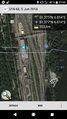
| Tue 5 Jun 2018 in 51,6: 51.3752197, 6.8140486 geohashing.info google osm bing/os kml crox |
Location
Right next to a lake close to Duisburg-Entenfang.
Participants
Expedition
On a nice summer evening, pah noticed that the today’s hash was only 200m away from an easy to reach train station. He quickly jumped on the next tram, took an “S-Bahn” to Duisburg and then the RB37 (Der Wedauer) to Duisburg Entenfang, where he arrived around one hour later.
During the remaining 200m of walking, pah realized how close the hash was located to the lake Entenfang. It took about 20 minutes of hash dancing - always scarily close to the water - until he caught a reasonably well GPS lock. And yes, the “proof” picture was taken less than the one meter away from the shore, which the GPS still reports as a distance. You have to trust me, that the jumping GPS coordinates never actually led him into the water, though.
Lucky to have reached the hash with dry feet, pah took some pictures and went back by train to Düsseldorf via Duisburg again.
Photos

Trip schedule
First, taking the tram 701
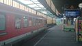
Boarding RB37 (Der Wedauer) in Duisburg
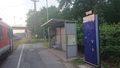
Arrived at Duisburg-Entenfang
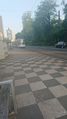
Remaining walk to the hash
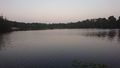
View at the lake
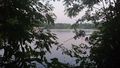
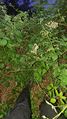
View from the hash
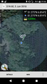
Proof #1
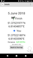
Proof #2
Still dry feet at the hash!
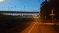
Waiting for RB37 (Der Wedauer) back to Duisburg


Achievements
pah
|