Difference between revisions of "2020-06-12 51 8"
(new report) |
m (subst-ing) |
||
| (2 intermediate revisions by 2 users not shown) | |||
| Line 1: | Line 1: | ||
| − | + | [[Image:{{{image|2020-06-12 51 8 GeorgDerReisende 1.png}}}|thumb|left]] | |
| − | + | {{meetup graticule | |
| + | | lat=51 | ||
| + | | lon=8 | ||
| + | | date=2020-06-12 | ||
| + | }} | ||
| − | |||
| − | |||
| − | |||
| − | |||
| − | |||
| − | |||
| − | |||
| − | |||
| − | |||
__NOTOC__ | __NOTOC__ | ||
== Location == | == Location == | ||
| − | + | ||
| + | The hash lay in the middle of a meadow at Willingen. | ||
== Participants == | == Participants == | ||
| − | + | ||
| − | + | [[User:GeorgDerReisende|GeorgDerReisende]] | |
== Plans == | == Plans == | ||
| − | + | ||
| + | Travel to Willingen, walking to the hash. | ||
== Expedition == | == Expedition == | ||
| − | |||
| − | + | The plan looked easy. Walking to the hash. | |
| − | |||
| − | + | But I don't have a running GPSr. So what to do. Ok, I use a planning tool. This tool can produce straigt lines. So I looked for things on the map, which could be a good bearing. And I found two single standing trees. Then with the measuring tool I counted the meters from points on the map. And I wanted to try the calculation from both sides to find out, if there is any mistake. | |
| − | |||
| − | |||
| − | |||
| − | |||
| − | |||
| − | + | I arrived at the meadow and at first I made the try from the left side. While walking along the path I noticed that I made big steps and decided not to calculate with calculated steps but with meters as steps. I walked uphill the left path until 119 meters and switched to the right into the direction of the small tree and walked 64 steps. Looked around. Looked for a mark on the meadow and found one. Then I walked down the hill and took the right path. Followed it for 93 meters, switched to the left and walked into the direction of the tree at the junction, it was the first of some going to the right. Went ahead for 80 steps and looked around. And I stood on the first trail, but the first trail lead some meters more to the right. I marked both points with my daypack and my maskbag and walked around and between these points and thought, I made it. | |
| − | |||
| − | |||
| − | + | == Photos == | |
| − | |||
| − | |||
| − | < | + | <gallery> |
| + | File:2020-06-12 51 8 GeorgDerReisende 6286.jpg | arrived | ||
| + | File:2020-06-12 51 8 GeorgDerReisende 6308.jpg | the meadow of the game | ||
| + | File:2020-06-12 51 8 GeorgDerReisende 6311.jpg | first following this trail | ||
| + | File:2020-06-12 51 8 GeorgDerReisende 6312.jpg | then 64 meters to the small tree | ||
| + | File:2020-06-12 51 8 GeorgDerReisende 6314.jpg | length of a step | ||
| + | File:2020-06-12 51 8 GeorgDerReisende 6315.jpg | the hash, first try | ||
| + | File:2020-06-12 51 8 GeorgDerReisende 6319.jpg | the small tree used as a bearing for the first try | ||
| + | File:2020-06-12 51 8 GeorgDerReisende 6318.jpg | 80 meters from here to the leftmost tree | ||
| + | File:2020-06-12 51 8 GeorgDerReisende 6324.jpg | the first trail | ||
| + | File:2020-06-12 51 8 GeorgDerReisende 6325.jpg | the second trail | ||
| + | File:2020-06-12 51 8 GeorgDerReisende 6326.jpg | site of the first try from the site of the second try | ||
| + | File:2020-06-12 51 8 GeorgDerReisende 6328.jpg | both places from above | ||
| + | File:2020-06-12 51 8 GeorgDerReisende 6329.jpg | looking north | ||
| + | File:2020-06-12 51 8 GeorgDerReisende 6330.jpg | east | ||
| + | File:2020-06-12 51 8 GeorgDerReisende 6331.jpg | south | ||
| + | File:2020-06-12 51 8 GeorgDerReisende 6332.jpg | west | ||
| + | File:2020-06-12 51 8 GeorgDerReisende 6335.jpg | the geohasher | ||
| + | </gallery> | ||
| − | + | [[Category:Expeditions]] | |
| − | |||
| − | [[Category: | ||
| − | |||
| − | + | [[Category:Expeditions with photos]] | |
| − | |||
| − | |||
| − | |||
| − | |||
| − | |||
[[Category:Expedition without GPS]] | [[Category:Expedition without GPS]] | ||
| − | + | ||
| − | |||
| − | |||
[[Category:Coordinates reached]] | [[Category:Coordinates reached]] | ||
| − | + | {{location|DE|HE|WA}} | |
| − | |||
| − | |||
| − | |||
| − | |||
| − | |||
| − | |||
| − | |||
| − | |||
| − | |||
| − | |||
| − | |||
| − | |||
| − | |||
| − | |||
| − | |||
| − | |||
| − | |||
Latest revision as of 20:16, 24 May 2024

| Fri 12 Jun 2020 in 51,8: 51.2893826, 8.6081934 geohashing.info google osm bing/os kml crox |
Location
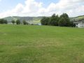
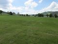
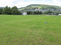
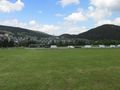
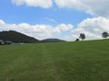
The hash lay in the middle of a meadow at Willingen.
Participants
Plans
Travel to Willingen, walking to the hash.
Expedition
The plan looked easy. Walking to the hash.
But I don't have a running GPSr. So what to do. Ok, I use a planning tool. This tool can produce straigt lines. So I looked for things on the map, which could be a good bearing. And I found two single standing trees. Then with the measuring tool I counted the meters from points on the map. And I wanted to try the calculation from both sides to find out, if there is any mistake.
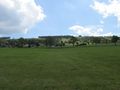
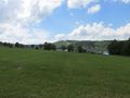
I arrived at the meadow and at first I made the try from the left side. While walking along the path I noticed that I made big steps and decided not to calculate with calculated steps but with meters as steps. I walked uphill the left path until 119 meters and switched to the right into the direction of the small tree and walked 64 steps. Looked around. Looked for a mark on the meadow and found one. Then I walked down the hill and took the right path. Followed it for 93 meters, switched to the left and walked into the direction of the tree at the junction, it was the first of some going to the right. Went ahead for 80 steps and looked around. And I stood on the first trail, but the first trail lead some meters more to the right. I marked both points with my daypack and my maskbag and walked around and between these points and thought, I made it.
Photos

arrived
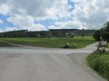
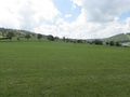
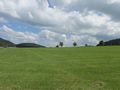
the meadow of the game
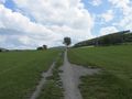
first following this trail
then 64 meters to the small tree
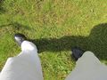
length of a step
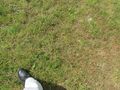
the hash, first try
the small tree used as a bearing for the first try
80 meters from here to the leftmost tree
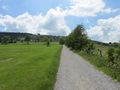
the first trail
the second trail
site of the first try from the site of the second try
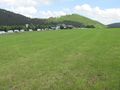
both places from above
looking north
east
south
west
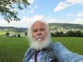
the geohasher


