Difference between revisions of "2021-10-03 55 38"
(Write the actual report) |
m (subst-ing) |
||
| (One intermediate revision by the same user not shown) | |||
| Line 2: | Line 2: | ||
{{meetup graticule | {{meetup graticule | ||
| − | | lat= | + | | lat=55 |
| − | | lon= | + | | lon=38 |
| − | | date= | + | | date=2021-10-03 |
}} | }} | ||
__NOTOC__ | __NOTOC__ | ||
| Line 39: | Line 39: | ||
[[Category:Expeditions with photos]] | [[Category:Expeditions with photos]] | ||
[[Category:Coordinates reached]] | [[Category:Coordinates reached]] | ||
| + | {{location|RU|MOS}} | ||
Latest revision as of 20:41, 24 May 2024
| Sun 3 Oct 2021 in 55,38: 55.7507381, 38.0868764 geohashing.info google osm bing/os kml crox |
Location
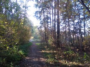
On a forest path near Chernoe (lit. black).
Participants
Plans
Figured this one would require a fair bit of travel, but fairly reachable otherwise.
Expedition
This probably was the easiest expedition so far, but still a very enjoyable one. Complete route looks like this: to train station by taxi, to Moscow by train, to different rail station by underground, to Zarya rail station near hash by train, to hash location by foot. Then in inverse order back home. Starting at 6:00 AM.
I've also missed one train to Zarya, but luckily there were two of them just a bit later to keep me on schedule.
After getting off the train on Zarya station (the one near the hash) and getting mandatory barking from local dog, I went around local houses and found hash in its expected location, on a forest path. Took a slightly different route back to station.
P.S.: I'm working on an app to make uploading correctly tagged an named pictures less tedious.
Tracklog


