Difference between revisions of "2023-08-24 31 34"
Yerushalmi (talk | contribs) (Created page with "{{subst:Expedition}}") |
m (subst-ing) |
||
| (4 intermediate revisions by 2 users not shown) | |||
| Line 8: | Line 8: | ||
And DON'T FORGET to add your expedition and the best photo you took to the gallery on the Main Page! We'd love to read your report, but that means we first have to discover it! :) | And DON'T FORGET to add your expedition and the best photo you took to the gallery on the Main Page! We'd love to read your report, but that means we first have to discover it! :) | ||
-->{{meetup graticule | -->{{meetup graticule | ||
| − | | lat= | + | | lat=31 |
| − | | lon= | + | | lon=34 |
| − | | date= | + | | date=2023-08-24 |
}}<!-- edit as necessary --> | }}<!-- edit as necessary --> | ||
== Location == | == Location == | ||
| − | + | Near Aderet. | |
| + | |||
| + | It's in a publicly accessible forest, which is good. But according to Amud Anan this specific part of the forest is a vineyard, which is bad. But Amud Anan claims the vineyard is long abandoned, which is good. But the satellite photos, which are probably more recent than the Amud Anan label, still show a clearly delineated plot of land, which may be bad. | ||
| + | |||
| + | The vineyard belongs theoretically to Ella Valley Wineries. It may be worth calling them in advance of going to the point to ask permission to enter. | ||
== Participants == | == Participants == | ||
| − | + | * [[User:Yerushalmi|Yerushalmi]] ([[User talk:Yerushalmi|talk]]), #4, and #5 | |
| − | |||
== Plans == | == Plans == | ||
| − | + | I called the winery and got permission! | |
| + | |||
| + | We'll leave by car from Jerusalem probably around 16:00... it's a bit late but I have other errands to run first. There's a marked red trail, and we'll hope for the best. | ||
== Expedition == | == Expedition == | ||
| − | + | Child #3 had a youth group thing, so my wife stayed home to take her there and pick her up afterwards; #1 and #2 decided not to come. So at 16:30 I took the car from Jerusalem with #4 and #5. Both fell asleep in the car. | |
| − | + | The vineyard is along a marked-red trail through the forest. I had been told by the winery over the phone that I could drive all the way down it, but when I got there I saw the sign marked it as for 4x4 vehicles only, which my car is not, so I didn't want to risk it. We parked the car at the start of the trail; the kids woke up immediately and we set off on foot. (The winery turned out to be right.) | |
| − | + | ||
| + | The geohash was pretty uneventful. It was a nice walk down a smoothly paved road in the middle of a forest. We stopped for lunch halfway down. | ||
| + | |||
| + | The vineyard turned out to still be in use - but as a wheat field rather than a vineyard. Since it's late summer, the harvest had already taken place, so the field was merely sitting there waiting for planting season. We walked in freely and found the point without issue. | ||
| + | |||
| + | Things got a little tense on the way back once the sun set, but we made it back to the car while there was still adequate light. | ||
== Photos == | == Photos == | ||
| Line 33: | Line 43: | ||
--> | --> | ||
<gallery perrow="5"> | <gallery perrow="5"> | ||
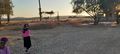
| + | Image:20230824_185312.jpg | Abandoned buildings that were used by the winery | ||
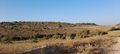
| + | Image:20230824_190015.jpg | Panorama at the point | ||
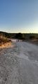
| + | Image:20230824_190055.jpg | Sunset | ||
| + | Image:Screenshot_20230824_180502_OsmAnd.jpg | Where we parked the car, and the path we took | ||
| + | Image:Screenshot_20230824_185959_Geohash Droid.jpg | Proof of arrival | ||
| + | Image:20230824_181248.jpg | ||
| + | Image:20230824_181251.jpg | ||
| + | Image:20230824_181258.jpg | ||
| + | Image:20230824_184147.jpg | ||
| + | Image:20230824_185310.jpg | ||
</gallery> | </gallery> | ||
| − | |||
| − | |||
| − | |||
| − | |||
__NOTOC__ | __NOTOC__ | ||
| − | |||
| − | |||
| − | |||
| − | |||
| − | |||
| − | |||
| − | |||
| − | |||
| − | |||
| − | |||
| − | |||
| − | |||
| − | |||
| − | |||
[[Category:Expeditions]] | [[Category:Expeditions]] | ||
| − | |||
[[Category:Expeditions with photos]] | [[Category:Expeditions with photos]] | ||
| − | |||
| − | |||
| − | |||
| − | |||
| − | |||
[[Category:Coordinates reached]] | [[Category:Coordinates reached]] | ||
| − | + | {{location|IL|JM}} | |
| − | |||
| − | |||
| − | |||
| − | |||
| − | |||
| − | |||
| − | |||
| − | |||
| − | |||
| − | |||
| − | |||
| − | |||
| − | |||
| − | |||
| − | |||
| − | |||
| − | |||
Latest revision as of 21:04, 24 May 2024
| Thu 24 Aug 2023 in 31,34: 31.6450231, 34.9805885 geohashing.info google osm bing/os kml crox |
Location
Near Aderet.
It's in a publicly accessible forest, which is good. But according to Amud Anan this specific part of the forest is a vineyard, which is bad. But Amud Anan claims the vineyard is long abandoned, which is good. But the satellite photos, which are probably more recent than the Amud Anan label, still show a clearly delineated plot of land, which may be bad.
The vineyard belongs theoretically to Ella Valley Wineries. It may be worth calling them in advance of going to the point to ask permission to enter.
Participants
- Yerushalmi (talk), #4, and #5
Plans
I called the winery and got permission!
We'll leave by car from Jerusalem probably around 16:00... it's a bit late but I have other errands to run first. There's a marked red trail, and we'll hope for the best.
Expedition
Child #3 had a youth group thing, so my wife stayed home to take her there and pick her up afterwards; #1 and #2 decided not to come. So at 16:30 I took the car from Jerusalem with #4 and #5. Both fell asleep in the car.
The vineyard is along a marked-red trail through the forest. I had been told by the winery over the phone that I could drive all the way down it, but when I got there I saw the sign marked it as for 4x4 vehicles only, which my car is not, so I didn't want to risk it. We parked the car at the start of the trail; the kids woke up immediately and we set off on foot. (The winery turned out to be right.)
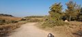
The geohash was pretty uneventful. It was a nice walk down a smoothly paved road in the middle of a forest. We stopped for lunch halfway down.
The vineyard turned out to still be in use - but as a wheat field rather than a vineyard. Since it's late summer, the harvest had already taken place, so the field was merely sitting there waiting for planting season. We walked in freely and found the point without issue.
Things got a little tense on the way back once the sun set, but we made it back to the car while there was still adequate light.
Photos
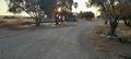
Abandoned buildings that were used by the winery
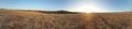
Panorama at the point
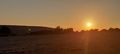
Sunset
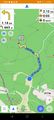
Where we parked the car, and the path we took

Proof of arrival