Difference between revisions of "2023-12-26 31 35"
Yerushalmi (talk | contribs) (Created page with "{{subst:Expedition}}") |
m (subst-ing) |
||
| (2 intermediate revisions by 2 users not shown) | |||
| Line 8: | Line 8: | ||
And DON'T FORGET to add your expedition and the best photo you took to the gallery on the Main Page! We'd love to read your report, but that means we first have to discover it! :) | And DON'T FORGET to add your expedition and the best photo you took to the gallery on the Main Page! We'd love to read your report, but that means we first have to discover it! :) | ||
-->{{meetup graticule | -->{{meetup graticule | ||
| − | | lat= | + | | lat=31 |
| − | | lon= | + | | lon=35 |
| − | | date= | + | | date=2023-12-26 |
}}<!-- edit as necessary --> | }}<!-- edit as necessary --> | ||
== Location == | == Location == | ||
| − | + | About 20 meters off of a path in the Jerusalem Hills, near Bar Giyora. Contour maps show steep inclines. | |
== Participants == | == Participants == | ||
| − | + | [[User:Yerushalmi|Yerushalmi]] ([[User talk:Yerushalmi|talk]]) | |
| − | |||
== Plans == | == Plans == | ||
| − | + | I'll take a bus from Jerusalem to a nearby intersection, walk to the point, then walk to another bus. Should be easy enough. | |
== Expedition == | == Expedition == | ||
| − | + | It was not easy. | |
| − | + | I missed the bus I was initially intending to take, but there were plenty of redundancies; there are a lot of towns in the area and buses that serve them and bring people back and forth to Jerusalem, so this did not unduly delay me. The bus dropped me off at Nes Harim intersection, where route 386 and route 3866 meet. There's a dirt path into the forest southeast of the intersection, which took me up and down the hillsides. Several parts of the path had massive puddles from recent rainfall that I walked either around or through. The path was wide and easy to follow, and at one point I sat down on exposed bedrock and ate lunch. | |
| − | |||
| − | + | Shortly afterwards, I reached the part of the path immediately parallel to the point from the south: | |
| − | + | ||
| − | + | [[File:20231226 southofthepath.png|400px]] | |
| − | + | ||
| − | + | And looking to the north, I stared into the face of the abyss: | |
| − | + | ||
| + | [[:File:20231226_121454.mp4]] | ||
| + | |||
| + | Well, nothing for it. I hadn't seen any safe way into the abyss so far, but I know that the path will later curve back around, and the point is far closer to the north than to the south. So maybe I'll be lucky and it'll be level with the part of the path and not actually inside the abyss. So I continued walking, and instead the path ''descended'' until it met the entrance to that valley - which turned out to actually be a creek bed. But now I'm faced with a decision: Do I walk off to the left, straight into the creek bed and the nettles and the bushes, and hope I can make it all the way to the point? Or do I continue on the path and hook around to the northwest? | ||
| + | |||
| + | [[File:20231226_124319.jpg|400px]] | ||
| + | |||
| + | Is the point close enough to the path that it's accessible from there, or is the hill steep enough that I can only reach it from below? | ||
| + | |||
| + | Well, climbing up is generally easier than climbing down, so I'll start into the creek bed and see what happens. | ||
| + | |||
| + | The creek bed was initially two-level (the creek itself, which was dry, and then surrounding area), then three-level. At each point I took the highest level open to me, with sometimes limited options due to spots of dense foliage. Then I saw this massive rock in the distance: | ||
| + | |||
| + | [[File:20231226_125159.jpg|400px]] | ||
| + | |||
| + | I'll have to climb it. Here's a good crevice in which to do so! | ||
| + | |||
| + | [[File:20231226_125555.jpg|400px]] | ||
| + | |||
| + | One foot in the crevice, the other foot higher up in the crevice, grab the rock above with one hand, reach out with the other - | ||
| + | |||
| + | Suddenly the hills rang out with a high-pitched cry of "AAAAH! SNAKE!" It was me. | ||
| + | |||
| + | There had been a brief flicker of forked tongue barely 30 centimeters from where I was about to put my right hand. I leaped backwards down the crevice as quickly as possible. (I tried to photograph the snake but my photography skills are execrable and it eventually moved to where I couldn't see it anymore.) | ||
| + | |||
| + | I'm generally not afraid of snakes on principle, and have happily held them on multiple occasions when told by an expert that they are of a safe species. Not being an expert myself, however, I didn't want to get any closer. | ||
| + | |||
| + | I looked around and saw no other ways forward. So let's go back to that intersection and try the path up top. This took me to within 20 meters of the point, but it looked too steep to risk jumping down and risk not being able to come back up: | ||
| + | |||
| + | [[File:20231226_130719.jpg|400px]] | ||
| + | |||
| + | Well, I did see a spot about ten meters back where the altitude difference was a lot smaller. The path was on top of what looked like an ancient retaining wall, and this part of the wall was overlooking a drop of only about two meters. So I carefully looked for snakes, took off my hiking backpack, left it on top of the wall with a strap dangling over the edge, and climbed down. Then I pulled the backpack down after me. | ||
| + | |||
| + | It dislodged one of the rocks of the wall, which fell down the slope and across my foot. | ||
| + | |||
| + | [[File:20231226_131058.jpg|400px]] | ||
| + | |||
| + | '''PRO TIP''': Rocks are heavy. Try not to get hit by one. | ||
| + | |||
| + | I shouted "Fork! Fork! Fork!" a few times, hopping around. It felt like twenty minutes but based on the photo timestamps it couldn't have been more than two. | ||
| + | |||
| + | Well, I'm only twenty meters away and the path, though dense with thornbushes, is level. I'm reaching this point no matter what. To make my life easier, I took off my hiking backpack (and took a note of the coordinates in case I had to take a roundabout way getting back and had trouble finding it). Walk to the point, walk back, check the wall for snakes, climb back onto the path. | ||
| + | |||
| + | Moovit said the best way back would be to take a bus from another town nearby called Tzur Hadassa. This path would briefly take me down the Israel National Trail, which I've run into a couple of times on previous expeditions. In this case, the trail took me past a goat form, which had a large number of guard dogs inside - and, though I did not see this at first, a broken fence. One of the dogs left and actually approached me, barking and snarling. Luckily, the path was very rocky, so I picked up some ammo in case I needed to hit the dog from afar. Even more luckily, it eventually left me alone without me having to resort to that. | ||
| + | |||
| + | Later down the path I found myself in a suburb outside Cairo: | ||
| − | + | [[File:Screenshot_20231226_134537_Geohash Droid.jpg|400px]] | |
| − | |||
| − | |||
| − | + | Not really, of course. This is intermittent GPS jamming due to the war. I'm good enough with maps that I knew which way to turn without live GPS, and eventually the jamming cleared up. It's just a pity that the jamming didn't show me anywhere near the point in 29 31, I could've been the first to reach the Giza graticule. | |
| − | |||
| − | |||
| − | |||
| − | + | When I reached Tzur Hadassah, I immediately discovered I had a problem: the bus stop that Moovit pointed me to was located at an entrance to the town that permanently closed off to vehicle traffic due to the war. I had to take another bus to get to the real bus stop. Annoying but it happens. | |
| − | + | == Photos == | |
| − | |||
| − | |||
| − | |||
| − | < | + | <gallery perrow="5"> |
| + | File:20231226_115538.jpg | The beginning of the path into the forest | ||
| + | File:20231226_121448.jpg | The abyss (much harder to see in the photo, the video is better) | ||
| + | File:20231226_124319.jpg | Do I take the low road or the high road? | ||
| + | File:20231226_124425.jpg | There's a pipe directly underneath the path, through which the creek would flow if it existed | ||
| + | File:20231226_124457.jpg | That crevice is the actual path of the creek, though this whole area is probably underwater when the rain is severe | ||
| + | File:20231226_125159.jpg | I'll have to climb that | ||
| + | File:20231226_125555.jpg | The Abode of the Snake | ||
| + | File:20231226_130719.jpg | Not jumping down here | ||
| + | File:20231226_131058.jpg | This wall was slightly bigger before I came and messed it up | ||
| + | File:20231226_131414.jpg | Twenty meters of thorns between me and the point | ||
| + | File:Screenshot_20231226_131610_Geohash Droid.jpg | Proof | ||
| + | File:20231226_131633.jpg | Panorama at the point | ||
| + | File:20231226_131944.jpg | Mushroom mushroom | ||
| + | File:20231226_132831.jpg | Lots of ancient walls in this area | ||
| + | File:Screenshot_20231226_134537_Geohash Droid.jpg | Look, mom, I'm in Egypt! | ||
| + | File:Screenshot_20231226_134635_Geohash Droid.jpg | And it took me less than a minute to return to Israel! | ||
| + | File:20231226_135214.jpg | A goat farm | ||
| + | File:20231226_135217.jpg | Same goat farm | ||
| + | </gallery> | ||
| − | + | __NOTOC__ | |
[[Category:Expeditions]] | [[Category:Expeditions]] | ||
| − | |||
[[Category:Expeditions with photos]] | [[Category:Expeditions with photos]] | ||
[[Category:Expeditions with videos]] | [[Category:Expeditions with videos]] | ||
| − | |||
| − | |||
| − | |||
| − | |||
[[Category:Coordinates reached]] | [[Category:Coordinates reached]] | ||
| − | + | {{location|IL|JM}} | |
| − | |||
| − | |||
| − | |||
| − | |||
| − | |||
| − | |||
| − | |||
| − | |||
| − | |||
| − | |||
| − | |||
| − | |||
| − | |||
| − | |||
| − | |||
| − | |||
| − | |||
Latest revision as of 21:12, 24 May 2024
| Tue 26 Dec 2023 in 31,35: 31.7318345, 35.0878964 geohashing.info google osm bing/os kml crox |
Location
About 20 meters off of a path in the Jerusalem Hills, near Bar Giyora. Contour maps show steep inclines.
Participants
Plans
I'll take a bus from Jerusalem to a nearby intersection, walk to the point, then walk to another bus. Should be easy enough.
Expedition
It was not easy.
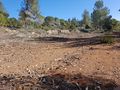
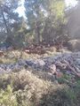
I missed the bus I was initially intending to take, but there were plenty of redundancies; there are a lot of towns in the area and buses that serve them and bring people back and forth to Jerusalem, so this did not unduly delay me. The bus dropped me off at Nes Harim intersection, where route 386 and route 3866 meet. There's a dirt path into the forest southeast of the intersection, which took me up and down the hillsides. Several parts of the path had massive puddles from recent rainfall that I walked either around or through. The path was wide and easy to follow, and at one point I sat down on exposed bedrock and ate lunch.
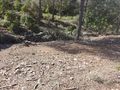
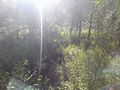
Shortly afterwards, I reached the part of the path immediately parallel to the point from the south:

And looking to the north, I stared into the face of the abyss:
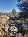
Well, nothing for it. I hadn't seen any safe way into the abyss so far, but I know that the path will later curve back around, and the point is far closer to the north than to the south. So maybe I'll be lucky and it'll be level with the part of the path and not actually inside the abyss. So I continued walking, and instead the path descended until it met the entrance to that valley - which turned out to actually be a creek bed. But now I'm faced with a decision: Do I walk off to the left, straight into the creek bed and the nettles and the bushes, and hope I can make it all the way to the point? Or do I continue on the path and hook around to the northwest?

Is the point close enough to the path that it's accessible from there, or is the hill steep enough that I can only reach it from below?
Well, climbing up is generally easier than climbing down, so I'll start into the creek bed and see what happens.
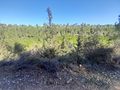
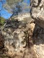
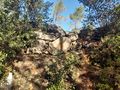
The creek bed was initially two-level (the creek itself, which was dry, and then surrounding area), then three-level. At each point I took the highest level open to me, with sometimes limited options due to spots of dense foliage. Then I saw this massive rock in the distance:

I'll have to climb it. Here's a good crevice in which to do so!

One foot in the crevice, the other foot higher up in the crevice, grab the rock above with one hand, reach out with the other -
Suddenly the hills rang out with a high-pitched cry of "AAAAH! SNAKE!" It was me.
There had been a brief flicker of forked tongue barely 30 centimeters from where I was about to put my right hand. I leaped backwards down the crevice as quickly as possible. (I tried to photograph the snake but my photography skills are execrable and it eventually moved to where I couldn't see it anymore.)
I'm generally not afraid of snakes on principle, and have happily held them on multiple occasions when told by an expert that they are of a safe species. Not being an expert myself, however, I didn't want to get any closer.
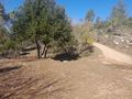
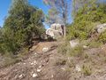
I looked around and saw no other ways forward. So let's go back to that intersection and try the path up top. This took me to within 20 meters of the point, but it looked too steep to risk jumping down and risk not being able to come back up:

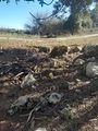
Well, I did see a spot about ten meters back where the altitude difference was a lot smaller. The path was on top of what looked like an ancient retaining wall, and this part of the wall was overlooking a drop of only about two meters. So I carefully looked for snakes, took off my hiking backpack, left it on top of the wall with a strap dangling over the edge, and climbed down. Then I pulled the backpack down after me.
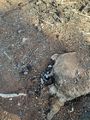
It dislodged one of the rocks of the wall, which fell down the slope and across my foot.

PRO TIP: Rocks are heavy. Try not to get hit by one.
I shouted "Fork! Fork! Fork!" a few times, hopping around. It felt like twenty minutes but based on the photo timestamps it couldn't have been more than two.
Well, I'm only twenty meters away and the path, though dense with thornbushes, is level. I'm reaching this point no matter what. To make my life easier, I took off my hiking backpack (and took a note of the coordinates in case I had to take a roundabout way getting back and had trouble finding it). Walk to the point, walk back, check the wall for snakes, climb back onto the path.
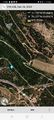
Moovit said the best way back would be to take a bus from another town nearby called Tzur Hadassa. This path would briefly take me down the Israel National Trail, which I've run into a couple of times on previous expeditions. In this case, the trail took me past a goat form, which had a large number of guard dogs inside - and, though I did not see this at first, a broken fence. One of the dogs left and actually approached me, barking and snarling. Luckily, the path was very rocky, so I picked up some ammo in case I needed to hit the dog from afar. Even more luckily, it eventually left me alone without me having to resort to that.
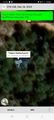
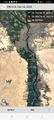
Later down the path I found myself in a suburb outside Cairo:

Not really, of course. This is intermittent GPS jamming due to the war. I'm good enough with maps that I knew which way to turn without live GPS, and eventually the jamming cleared up. It's just a pity that the jamming didn't show me anywhere near the point in 29 31, I could've been the first to reach the Giza graticule.
When I reached Tzur Hadassah, I immediately discovered I had a problem: the bus stop that Moovit pointed me to was located at an entrance to the town that permanently closed off to vehicle traffic due to the war. I had to take another bus to get to the real bus stop. Annoying but it happens.
Photos
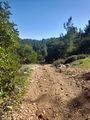
The beginning of the path into the forest
The abyss (much harder to see in the photo, the video is better)
Do I take the low road or the high road?
There's a pipe directly underneath the path, through which the creek would flow if it existed
That crevice is the actual path of the creek, though this whole area is probably underwater when the rain is severe
I'll have to climb that
The Abode of the Snake
Not jumping down here
This wall was slightly bigger before I came and messed it up
Twenty meters of thorns between me and the point
Proof
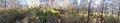
Panorama at the point
Mushroom mushroom
Lots of ancient walls in this area
Look, mom, I'm in Egypt!
And it took me less than a minute to return to Israel!
A goat farm
Same goat farm


