Difference between revisions of "2024-03-08 31 35"
Yerushalmi (talk | contribs) (Created page with "{{subst:Expedition}}") |
m (subst-ing) |
||
| (2 intermediate revisions by 2 users not shown) | |||
| Line 8: | Line 8: | ||
And DON'T FORGET to add your expedition and the best photo you took to the gallery on the Main Page! We'd love to read your report, but that means we first have to discover it! :) | And DON'T FORGET to add your expedition and the best photo you took to the gallery on the Main Page! We'd love to read your report, but that means we first have to discover it! :) | ||
-->{{meetup graticule | -->{{meetup graticule | ||
| − | | lat= | + | | lat=31 |
| − | | lon= | + | | lon=35 |
| − | | date= | + | | date=2024-03-08 |
}}<!-- edit as necessary --> | }}<!-- edit as necessary --> | ||
== Location == | == Location == | ||
| − | + | A forest outside of Jerusalem, either on or very close to a path. Eminently accessible any day but Friday. Also accessible on a Friday if I get an early enough start, but I'll have to take the car if I want to return in time to cook for Shabbat. | |
| + | |||
== Participants == | == Participants == | ||
| − | + | [[User:Yerushalmi|Yerushalmi]] ([[User talk:Yerushalmi|talk]]) | |
| − | |||
== Plans == | == Plans == | ||
| − | + | Wake up, drive the car to the entrance to the path, walk a couple of hundred meters to the point, walk back to the car, drive home. It won't be that simple, but if there are any complications I will not have the time to circumvent them - I'll need to go straight home. | |
== Expedition == | == Expedition == | ||
| − | + | It was that simple. But also momentarily very scary. | |
| − | + | I left Jerusalem via route 386. According to the map the turnoff would be the first one after the sewage treatment plant. I had a momentary worry when I saw, after the sewage treatment plant, a turnoff into a construction site - maybe the path is being worked on or built on and the point is inaccessible? But I kept driving and found the actual turnoff a bit later. | |
| − | |||
| − | + | I parked the car and walked through a cloud of midges towards the point. The first challenge was walking through the Sorek River, which was at a relative height (shin height) thanks to recent rainfall. My boots now sloshing, I walked past an Arab goat herder and said shalom (he said ahalan back). I'm only 200 meters from the point. | |
| − | + | ||
| − | + | A few moments later my heart dropped into my stomach: three offroad vehicles driven by young Arabs were coming down the path in my direction. | |
| − | |||
| − | |||
| − | |||
| − | + | Okay. Deep breath, stay calm. This is one of the most famous and known nature trails outside of Jerusalem. It's a safe area. If they're Arab Israelis, the vast majority are perfectly good people; and if they're Palestinians intent on kidnapping someone they wouldn't be way out here, they'd be in the city itself. | |
| − | |||
| − | |||
| − | + | I sent a quick message to my wife telling her where I was and to expect a panorama from the point shortly, but without telling her why so as not to worry her unnecessarily. I kept walking to the point, reached it easily, and walked back to the car. I did not die. | |
| − | |||
| − | |||
| − | |||
| − | + | Annoyingly, I couldn't turn left back onto 386; I had to turn right and continue to the next roundabout, then make a U-turn to head back towards Jerusalem. | |
| − | < | + | == Photos == |
| − | + | <gallery> | |
| − | + | File:20240308_084420.jpg | At the entrance to the path, a long-unused cattle grid. | |
| − | + | File:20240308_084435.jpg | Signpost | |
| + | File:20240308_084459.jpg | Trail map | ||
| + | File:20240308_084526.jpg | Uh... oops. Turns out I misread the sign. At the time I thought it said "The Irish Bridge is flooded - no passage except for pedestrians and mountain bikes only". It actually says no passage for anybody, and pedestrians and mountain bikes can proceed only if they take a different trail 500 meters to the north. Um.... sorry? | ||
| + | File:20240308_084608.jpg | The river across the Irish bridge, and a goat herder in the background | ||
| + | File:20240308_085422.jpg | Panorama at the point | ||
| + | File:Screenshot_20240308_085415_Geohash Droid.jpg | Proof | ||
| + | File:20240308_085657.jpg | View of the river from above | ||
| + | </gallery> | ||
| − | + | __NOTOC__ | |
| − | |||
[[Category:Expeditions]] | [[Category:Expeditions]] | ||
| − | |||
[[Category:Expeditions with photos]] | [[Category:Expeditions with photos]] | ||
| − | |||
| − | |||
| − | |||
| − | |||
| − | |||
[[Category:Coordinates reached]] | [[Category:Coordinates reached]] | ||
| − | + | {{location|IL|JM}} | |
| − | |||
| − | |||
| − | |||
| − | |||
| − | |||
| − | |||
| − | |||
| − | |||
| − | |||
| − | |||
| − | |||
| − | |||
| − | |||
| − | |||
| − | |||
| − | |||
| − | |||
Latest revision as of 21:16, 24 May 2024
| Fri 8 Mar 2024 in 31,35: 31.7577230, 35.0852613 geohashing.info google osm bing/os kml crox |
Location
A forest outside of Jerusalem, either on or very close to a path. Eminently accessible any day but Friday. Also accessible on a Friday if I get an early enough start, but I'll have to take the car if I want to return in time to cook for Shabbat.
Participants
Plans
Wake up, drive the car to the entrance to the path, walk a couple of hundred meters to the point, walk back to the car, drive home. It won't be that simple, but if there are any complications I will not have the time to circumvent them - I'll need to go straight home.
Expedition
It was that simple. But also momentarily very scary.
I left Jerusalem via route 386. According to the map the turnoff would be the first one after the sewage treatment plant. I had a momentary worry when I saw, after the sewage treatment plant, a turnoff into a construction site - maybe the path is being worked on or built on and the point is inaccessible? But I kept driving and found the actual turnoff a bit later.
I parked the car and walked through a cloud of midges towards the point. The first challenge was walking through the Sorek River, which was at a relative height (shin height) thanks to recent rainfall. My boots now sloshing, I walked past an Arab goat herder and said shalom (he said ahalan back). I'm only 200 meters from the point.
A few moments later my heart dropped into my stomach: three offroad vehicles driven by young Arabs were coming down the path in my direction.
Okay. Deep breath, stay calm. This is one of the most famous and known nature trails outside of Jerusalem. It's a safe area. If they're Arab Israelis, the vast majority are perfectly good people; and if they're Palestinians intent on kidnapping someone they wouldn't be way out here, they'd be in the city itself.
I sent a quick message to my wife telling her where I was and to expect a panorama from the point shortly, but without telling her why so as not to worry her unnecessarily. I kept walking to the point, reached it easily, and walked back to the car. I did not die.
Annoyingly, I couldn't turn left back onto 386; I had to turn right and continue to the next roundabout, then make a U-turn to head back towards Jerusalem.
Photos
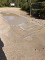
At the entrance to the path, a long-unused cattle grid.
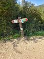
Signpost
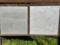
Trail map
Uh... oops. Turns out I misread the sign. At the time I thought it said "The Irish Bridge is flooded - no passage except for pedestrians and mountain bikes only". It actually says no passage for anybody, and pedestrians and mountain bikes can proceed only if they take a different trail 500 meters to the north. Um.... sorry?
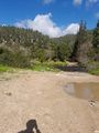
The river across the Irish bridge, and a goat herder in the background
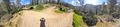
Panorama at the point

Proof
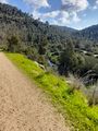
View of the river from above


