Difference between revisions of "2024-06-27 -38 145"
From Geohashing
(Created page with "{{subst:Expedition}}") |
|||
| (6 intermediate revisions by the same user not shown) | |||
| Line 9: | Line 9: | ||
-->{{meetup graticule|date=2024-06-27|lat=-38|lon=145}} | -->{{meetup graticule|date=2024-06-27|lat=-38|lon=145}} | ||
== Location == | == Location == | ||
| − | + | On a vacant plot in Pakenham | |
== Participants == | == Participants == | ||
| − | + | Expedition One | |
| − | + | *[[User:BarbaraTables|BarbaraTables]] | |
| − | == | + | == Expedition == |
| − | <!-- | + | ===Expedition One=== |
| + | To be added later | ||
| + | <gallery mode="packed" heights="300px"> | ||
| + | File:2024-06-27_-38_145_view_of_hash.JPEG|It's in the corner! | ||
| + | File:2024-06-27_-38_145_view_at_hash.JPEG|Now I'm in the corner! | ||
| + | File:2024-06-27_-38_145_proof.PNG|Proof | ||
| + | </gallery> | ||
| − | == | + | {{#vardefine:ribbonwidth|100%}} |
| − | + | {{land geohash | |
| + | |||
| + | | latitude = -38 | ||
| + | | longitude = 145 | ||
| + | | date = 2024-06-27 | ||
| + | | name = [[User:BarbaraTables|BarbaraTables]] | ||
| + | |||
| + | }} | ||
| + | {{Minesweeper geohash | ||
| + | |||
| + | | graticule = Melbourne West, Australia | ||
| + | | ranknumber = 3 | ||
| + | | n = true | ||
| + | | e = true | ||
| + | | se = true | ||
| + | | name = [[User:BarbaraTables|BarbaraTables]] | ||
| + | |||
| + | }} | ||
| + | {{Public transport geohash | ||
| + | |||
| + | | latitude = -38 | ||
| + | | longitude = 145 | ||
| + | | date = 2024-06-27 | ||
| + | | name = [[User:BarbaraTables|BarbaraTables]] | ||
| − | + | }} | |
| − | + | {{Two to the N achievement | |
| − | == | + | | count = 4 |
| − | + | | date = 2024-06-27 | |
| − | + | | latitude = -38 | |
| − | + | | longitude = 145 | |
| − | + | | name = [[User:BarbaraTables|BarbaraTables]] | |
| − | + | | reached = true | |
| − | + | }} | |
| − | |||
| − | |||
__NOTOC__ | __NOTOC__ | ||
| Line 39: | Line 66: | ||
Delete the next line ONLY if you have chosen the appropriate categories below. If you are unsure, don't worry. People will read your report and help you with the classification. --> | Delete the next line ONLY if you have chosen the appropriate categories below. If you are unsure, don't worry. People will read your report and help you with the classification. --> | ||
[[Category:New report]] | [[Category:New report]] | ||
| − | |||
| − | |||
| − | |||
| − | |||
| − | |||
| − | |||
| − | |||
[[Category:Expeditions]] | [[Category:Expeditions]] | ||
| − | |||
[[Category:Expeditions with photos]] | [[Category:Expeditions with photos]] | ||
| − | |||
| − | |||
| − | |||
| − | |||
[[Category:Coordinates reached]] | [[Category:Coordinates reached]] | ||
| − | |||
| − | |||
| − | |||
| − | |||
| − | |||
| − | |||
| − | |||
| − | |||
| − | |||
| − | |||
| − | |||
| − | |||
| − | |||
| − | |||
Revision as of 07:35, 27 June 2024
| Thu 27 Jun 2024 in -38,145: -38.0574982, 145.4620776 geohashing.info google osm bing/os kml crox |
Location
On a vacant plot in Pakenham
Participants
Expedition One
Expedition
Expedition One
To be added later
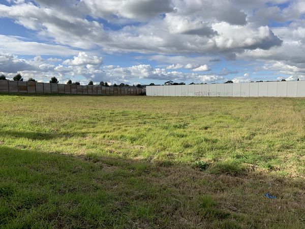
It's in the corner!
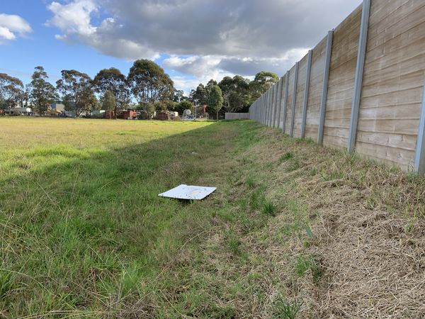
Now I'm in the corner!
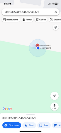
Proof


BarbaraTables earned the Land geohash achievement
|
BarbaraTables achieved level 3 of the Minesweeper Geohash achievement
|
BarbaraTables earned the Public transport geohash achievement
|

BarbaraTables earned the Two to the N achievement
by reaching 24 hashpoints on 2024-06-27 -38 145 and is promoted to Level 4 (Coordinates reached).