Difference between revisions of "2024-06-29 49 8"
From Geohashing
Green guy! (talk | contribs) m (Typo and time) |
Green guy! (talk | contribs) (Add title image and achievements) |
||
| (2 intermediate revisions by the same user not shown) | |||
| Line 1: | Line 1: | ||
| − | <!-- Title image | + | <!-- Title image --> |
| − | + | [[File:OMIMG_20240629_113804.jpg|300px|thumb|right]] | |
<!-- And DON'T FORGET to add your expedition and the best photo you took to the gallery on the Main Page! We'd love to read your report, but that means we first have to discover it! :) --> | <!-- And DON'T FORGET to add your expedition and the best photo you took to the gallery on the Main Page! We'd love to read your report, but that means we first have to discover it! :) --> | ||
| Line 9: | Line 9: | ||
}} | }} | ||
== Location == | == Location == | ||
| − | |||
In a forest area, about 60 meters away from the closest path (according to OpenStreetMap), in Darmstadt-Dieburg county, Hesse, Germany. The closest built-up area is the commercial park of Weiterstadt in south direction, over the ''Rhein-Main'' railway. | In a forest area, about 60 meters away from the closest path (according to OpenStreetMap), in Darmstadt-Dieburg county, Hesse, Germany. The closest built-up area is the commercial park of Weiterstadt in south direction, over the ''Rhein-Main'' railway. | ||
| − | This day’s weather | + | This day’s weather: sunny with a few clouds, warm, getting really hot and sticky in the course of the day |
== Participants == | == Participants == | ||
| Line 31: | Line 30: | ||
<!-- After lunch, we visited the hashpoint: We parked our car ____ and ____ --> | <!-- After lunch, we visited the hashpoint: We parked our car ____ and ____ --> | ||
| − | == Tracklog: Walking to the hashpoint | + | == Tracklog: Walking to the hashpoint == |
| − | + | * I started the tracklog in the car near Weiterstadt and stopped it when coming back to the car after the expedition. | |
| − | + | * GPS accuracy: medium | |
| − | * I | + | * Markers show all locations where I took photos – a few of them are taken for OpenStreetMap surveying. |
| − | + | {{Tracklog|GH 2024-06-29 49 8 at 11-09.gpx}} | |
| − | * GPS accuracy: | ||
| − | * Markers show all locations where I took photos | ||
| − | |||
| − | |||
== Pictures == | == Pictures == | ||
| − | |||
<!-- File:2024-##-## ## ## _____.jpg | Witty Comment --> | <!-- File:2024-##-## ## ## _____.jpg | Witty Comment --> | ||
<gallery> | <gallery> | ||
| + | File:OMIMG_20240629_111412.jpg | ||
| + | File:OMIMG_20240629_111439.jpg | ||
| + | File:OMIMG_20240629_111602.jpg | ||
| + | File:OMIMG_20240629_111629.jpg | ||
| + | File:OMIMG_20240629_111742.jpg | ||
| + | File:OMIMG_20240629_111859.jpg | ||
| + | File:OMIMG_20240629_112339.jpg | ||
| + | File:OMIMG_20240629_112635.jpg | ||
| + | File:OMIMG_20240629_112759.jpg | ||
| + | File:OMIMG_20240629_113010.jpg | ||
| + | File:OMIMG_20240629_113053.jpg | ||
| + | File:OMIMG_20240629_113314.jpg | ||
| + | File:OMIMG_20240629_113537.jpg | ||
| + | File:OMIMG_20240629_113628.jpg | ||
| + | File:OMIMG_20240629_113720.jpg | ||
| + | File:Screenshot_20240629-113759_OruxMaps.png | Coordinates reached | ||
| + | File:OMIMG_20240629_113804.jpg | ||
| + | File:OMIMG_20240629_113817.jpg | ||
| + | File:OMIMG_20240629_114013.jpg | ||
| + | File:OMIMG_20240629_114426.jpg | ||
| + | File:OMIMG_20240629_115104.jpg | ||
| + | File:OMIMG_20240629_115200.jpg | ||
| + | File:OMIMG_20240629_115303.jpg | ||
| + | File:OMIMG_20240629_115415.jpg | ||
| + | File:OMIMG_20240629_115433.jpg | ||
| + | File:OMIMG_20240629_115456.jpg | ||
| + | File:OMIMG_20240629_115524.jpg | ||
| + | File:OMIMG_20240629_115554.jpg | ||
| + | File:OMIMG_20240629_115632.jpg | ||
</gallery> | </gallery> | ||
| − | |||
== Achievements == | == Achievements == | ||
| Line 53: | Line 75: | ||
I earned these for the first time from this geohash. | I earned these for the first time from this geohash. | ||
{{#vardefine:ribbonwidth|100%}} | {{#vardefine:ribbonwidth|100%}} | ||
| − | + | {{Two to the N achievement | |
| count = 3 | | count = 3 | ||
| latitude = {{#explode:{{SUBPAGENAME}}| |1}} | | latitude = {{#explode:{{SUBPAGENAME}}| |1}} | ||
| Line 60: | Line 82: | ||
| name = [[User:Green guy!|Green guy!]] ([[User talk:Green guy!|talk]]) | | name = [[User:Green guy!|Green guy!]] ([[User talk:Green guy!|talk]]) | ||
| reached = true | | reached = true | ||
| − | }} | + | }} |
=== Recurring === | === Recurring === | ||
I already earned these from an earlier geohash, but fulfilled the conditions again on this one. | I already earned these from an earlier geohash, but fulfilled the conditions again on this one. | ||
| Line 73: | Line 95: | ||
| name = [[User:Green guy!|Green guy!]] ([[User talk:Green guy!|talk]]) | | name = [[User:Green guy!|Green guy!]] ([[User talk:Green guy!|talk]]) | ||
}} --> | }} --> | ||
| − | + | {{land geohash | |
| latitude = {{#explode:{{SUBPAGENAME}}| |1}} | | latitude = {{#explode:{{SUBPAGENAME}}| |1}} | ||
| longitude = {{#explode:{{SUBPAGENAME}}| |2}} | | longitude = {{#explode:{{SUBPAGENAME}}| |2}} | ||
| date = {{#explode:{{SUBPAGENAME}}| |0}} | | date = {{#explode:{{SUBPAGENAME}}| |0}} | ||
| name = [[User:Green guy!|Green guy!]] ([[User talk:Green guy!|talk]]) | | name = [[User:Green guy!|Green guy!]] ([[User talk:Green guy!|talk]]) | ||
| − | }} | + | }} |
__NOTOC__ | __NOTOC__ | ||
| Line 88: | Line 110: | ||
<!-- ==REQUEST FOR TWITTER BOT== Please leave either the New report or the Expedition planning category in as long as you work on it. This helps the twitter bot a lot with announcing the right outcome at the right moment. --> | <!-- ==REQUEST FOR TWITTER BOT== Please leave either the New report or the Expedition planning category in as long as you work on it. This helps the twitter bot a lot with announcing the right outcome at the right moment. --> | ||
| − | + | [[Category:Expeditions]] | |
| − | + | [[Category:Expeditions with photos]] | |
| − | |||
| − | |||
| − | |||
| − | |||
| − | |||
| − | |||
| − | |||
| − | |||
| − | + | [[Category:Coordinates reached]] | |
| − | |||
| − | |||
| − | |||
| − | |||
| − | |||
| − | |||
| − | |||
| − | |||
Revision as of 13:25, 29 June 2024

| Sat 29 Jun 2024 in 49,8: 49.9030150, 8.6133894 geohashing.info google osm bing/os kml crox |
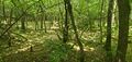
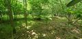
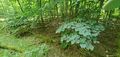
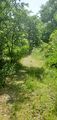
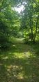
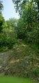
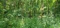
Location
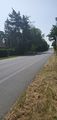
In a forest area, about 60 meters away from the closest path (according to OpenStreetMap), in Darmstadt-Dieburg county, Hesse, Germany. The closest built-up area is the commercial park of Weiterstadt in south direction, over the Rhein-Main railway.
This day’s weather: sunny with a few clouds, warm, getting really hot and sticky in the course of the day
Participants
- Green guy! (talk)
- Green guy!’s mother (no consent to publish photos of her)
- Green guy!’s father (no consent to publish photos of him)
Plans
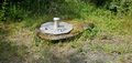
- Drive near the geohash before it gets too hot and sticky! (likely around 11 am)
- Park our car next to the Wasserwerk (water works)
- Go on a forest walk to visit the hashpoint
- Drive back home
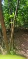
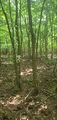
Expedition
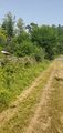
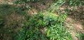
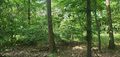
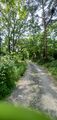
Tracklog: Walking to the hashpoint
- I started the tracklog in the car near Weiterstadt and stopped it when coming back to the car after the expedition.
- GPS accuracy: medium
- Markers show all locations where I took photos – a few of them are taken for OpenStreetMap surveying.
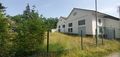
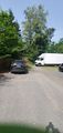
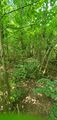
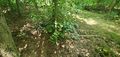
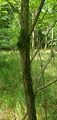
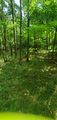
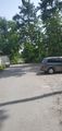
Pictures
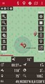
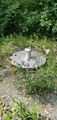
Coordinates reached


Achievements
First-time
I earned these for the first time from this geohash.

by reaching 23 hashpoints on 2024-06-29 49 8 and is promoted to Level 3 (Coordinates reached).
Recurring
I already earned these from an earlier geohash, but fulfilled the conditions again on this one.
Green guy! (talk) earned the Land geohash achievement
|