Difference between revisions of "2024-06-29 58 5"
From Geohashing
(→Location) |
(→Achievements) |
||
| (16 intermediate revisions by the same user not shown) | |||
| Line 8: | Line 8: | ||
And DON'T FORGET to add your expedition and the best photo you took to the gallery on the Main Page! We'd love to read your report, but that means we first have to discover it! :) | And DON'T FORGET to add your expedition and the best photo you took to the gallery on the Main Page! We'd love to read your report, but that means we first have to discover it! :) | ||
-->{{meetup graticule|date=2024-06-29|lat=58|lon=5}} | -->{{meetup graticule|date=2024-06-29|lat=58|lon=5}} | ||
| + | |||
| + | [[Image:20240629_Me.jpg|thumb|left]] | ||
== Location == | == Location == | ||
<!-- where you've surveyed the hash to be --> | <!-- where you've surveyed the hash to be --> | ||
| Line 16: | Line 18: | ||
<!-- who attended: If you link to your wiki user name in this section, your expedition will be picked up by the various statistics generated for geohashing. You may use three tildes ~ as a shortcut to automatically insert the user signature of the account you are editing with. | <!-- who attended: If you link to your wiki user name in this section, your expedition will be picked up by the various statistics generated for geohashing. You may use three tildes ~ as a shortcut to automatically insert the user signature of the account you are editing with. | ||
--> | --> | ||
| + | |||
| + | *[[User:Pica42|Pica42]] | ||
== Plans == | == Plans == | ||
| Line 22: | Line 26: | ||
== Expedition == | == Expedition == | ||
<!-- how it all turned out. your narrative goes here. --> | <!-- how it all turned out. your narrative goes here. --> | ||
| + | |||
| + | Then there finally came a day when it was appropriate to have a bike ride to find a geohash. It fit well with the zero point on the cycle path and I used the opportunity to stretch my legs a bit. The trip was a total of 39.13 km. | ||
== Tracklog == | == Tracklog == | ||
| Line 33: | Line 39: | ||
Image:2024-06-29_58_5_Pica42_1719668800953.jpg|Sola [https://openstreetmap.org/?mlat=58.90301680&mlon=5.61332330&zoom=16 @58.9030,5.6133] | Image:2024-06-29_58_5_Pica42_1719668800953.jpg|Sola [https://openstreetmap.org/?mlat=58.90301680&mlon=5.61332330&zoom=16 @58.9030,5.6133] | ||
| + | Image:20240629 58 5 W.jpg|thumb|View to the west | ||
| + | Image:20240629_58 5 S.jpg|thumb|View to the south | ||
| + | Image:20240629 58 5 E.jpg|thumb|View to the east | ||
| + | Image:20240629_58 5 N.jpg|thumb|View to the north | ||
</gallery> | </gallery> | ||
| Line 39: | Line 49: | ||
<!-- Add any achievement ribbons you earned below, or remove this section --> | <!-- Add any achievement ribbons you earned below, or remove this section --> | ||
| − | + | {{land geohash |name=[[User:Pica42|Pica42]] |date=2024-06-29 |latitude=58 |longitude=5 }} | |
| − | |||
| − | |||
| − | [[ | ||
| − | |||
| − | |||
| − | |||
| − | |||
| − | |||
| − | |||
| − | |||
[[Category:Expeditions]] | [[Category:Expeditions]] | ||
| − | |||
[[Category:Expeditions with photos]] | [[Category:Expeditions with photos]] | ||
| − | |||
| − | |||
| − | |||
| − | |||
[[Category:Coordinates reached]] | [[Category:Coordinates reached]] | ||
| + | {{location|NO|11}} | ||
| − | -- | + | {{Bicycle geohash | latitude = 58 | longitude = 5 | date = 2024-06-29 | name = Pica42 }} |
| − | |||
| − | |||
| − | |||
| − | |||
| − | + | __NOTOC__ | |
| − | |||
| − | |||
| − | |||
| − | |||
| − | |||
| − | |||
Latest revision as of 17:55, 29 June 2024
| Sat 29 Jun 2024 in 58,5: 58.9030150, 5.6133894 geohashing.info google osm bing/os kml crox |

Location
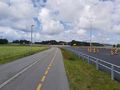
On a cycle path by the road between Sola and Tananger, Rogaland, Norway.
Participants
Plans
Expedition
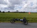
Then there finally came a day when it was appropriate to have a bike ride to find a geohash. It fit well with the zero point on the cycle path and I used the opportunity to stretch my legs a bit. The trip was a total of 39.13 km.
Tracklog
Photos
Sola @58.9030,5.6133
View to the west
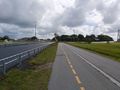
View to the south
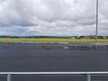
View to the east
View to the north


Achievements
Pica42 earned the Land geohash achievement
|
Pica42 earned the Bicycle geohash achievement
|