Difference between revisions of "2024-07-08 65 24"
m (Location) |
|||
| (4 intermediate revisions by one other user not shown) | |||
| Line 10: | Line 10: | ||
== Expedition == | == Expedition == | ||
| − | + | [https://en.wikipedia.org/wiki/Hailuoto Hailuoto] is the largest island | |
| + | in [https://en.wikipedia.org/wiki/Bothnian_Bay the Bay of Bothnia]. | ||
| + | It is permanently populated with a population of about a thousand. | ||
| + | There is no permanent road connection to the mainland, | ||
| + | only a ferry throughout the year and an ice road in the winter, | ||
| + | however a series of bridges and embankments is currently under construction and is supposed to be finished in 2026. | ||
| + | We had considered doing a cycling trip there in the summer | ||
| + | but had not got around to going yet. | ||
| + | Since the geohash was in a likely easily accessible place | ||
| + | and since we both were finally on summer holiday, | ||
| + | we decided to go today. | ||
| + | |||
| + | We cycled from home to the ferry port in Oulunsalo where we got to board the ferry almost immediately at 14:10. | ||
| + | The scheduled departure that we aimed at was 14:30, but there was another small ferry running non-stop | ||
| + | that happened to depart at a convenient time. | ||
| + | During our first hour outside, it was cloudy and occasionally raining a little, | ||
| + | and it was also very windy especially on the sea. | ||
| + | The temperature was around 17 °C. | ||
| + | The ferry ride took about half an hour, after which we felt slightly cold, | ||
| + | but then the sky cleared and the sun started to shine. | ||
| + | We continued cycling on the island towards the hashpoint and quickly got warm again. | ||
| + | Strong headwind made our progress heavy and slow. | ||
| + | |||
| + | Fiancée went to have dinner at a restaurant while I went off the main road to visit the hashpoint. | ||
| + | The paved road turned into a gravel road and then into a sandy field road, | ||
| + | and the hashpoint was about 10 metres off the road. | ||
| + | There was barley growing in the field, which was a little worrying at first, | ||
| + | but I was able to walk to the hashpoint without trampling any crops. | ||
| + | The hashpoint turned out to be on a tyre track of a tractor, | ||
| + | so I could stand there without worries. | ||
| + | I soon walked back to the bicycle and returned to the junction where Fiancée was waiting for me. | ||
| + | |||
| + | We cycled towards Hailuoto village and visited a couple of shops there. | ||
| + | We had considered going all the way to Marjaniemi, the westernmost place of the island, | ||
| + | but it was getting late and we were tired of cycling against the wind, | ||
| + | so we turned back instead. | ||
| + | The journey back to the ferry went more easily. | ||
| + | Having not considered the schedule of the return, | ||
| + | we ended up missing the 19:00 ferry by about 15 minutes, | ||
| + | so we had to wait in the café until it returned and departed at 20:10. | ||
| + | By then, the small non-stop ferry had stopped running. | ||
| + | The final journey from Oulunsalo to home went well enough | ||
| + | considering that we were already pretty tired and aching in places. | ||
| + | |||
| + | The trip took us about nine hours. | ||
| + | I cycled 91.2 km and Fiancée cycled 85.8 km in total. | ||
== Tracklog == | == Tracklog == | ||
| Line 16: | Line 61: | ||
== Photos == | == Photos == | ||
| − | < | + | <gallery perrow="13"> |
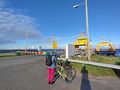
| − | Image:2024- | + | Image:2024-07-08_65_24_01-oulunsalo.jpg|Oulunsalo ferry port. The wind is blowing hard. |
| − | -- | + | Image:2024-07-08_65_24_02-ferry1.jpg|Loading the ferry. |
| − | + | Image:2024-07-08_65_24_03-clouds.jpg|The sky is going to brighten soon. | |
| + | Image:2024-07-08_65_24_04-hailuoto-info.jpg|Hailuoto information board. | ||
| + | Image:2024-07-08_65_24_05-road.jpg|The main road of the island. | ||
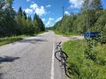
| + | Image:2024-07-08_65_24_06-junction.jpg|The junction where I diverted towards the hashpoint. | ||
| + | Image:2024-07-08_65_24_07-field.jpg|My bicycle parked to the field road, about ten metres to go. | ||
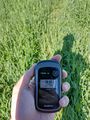
| + | Image:2024-07-08_65_24_08-gpsr1.jpg|Proof of location. | ||
| + | Image:2024-07-08_65_24_09-gpsr2.jpg|Proof of date and time. | ||
| + | Image:2024-07-08_65_24_10-selfie.jpg|Selfie at the hashpoint. | ||
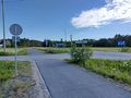
| + | Image:2024-07-08_65_24_11-shop.jpg|Where we turned back; shop and café in the central village. | ||
| + | Image:2024-07-08_65_24_12-ferrysign.jpg|Approaching Hailuoto ferry port. | ||
| + | Image:2024-07-08_65_24_13-ferry2.jpg|The ferry has just arrived and will unload soon so we can enter. | ||
</gallery> | </gallery> | ||
| Line 29: | Line 84: | ||
| name=[[User:Kripakko|Kripakko]] | | name=[[User:Kripakko|Kripakko]] | ||
}} | }} | ||
| + | {{consecutive geohash 3 | ||
| + | | name = [[User:Kripakko|Kripakko]] | ||
| + | | latitude = 64 | ||
| + | | longitude = 25 | ||
| + | | date = 2024-07-07 | ||
| + | | hashcount = 2 | ||
| + | | daycount = 2 | ||
| + | }} | ||
__NOTOC__ | __NOTOC__ | ||
| − | |||
| − | |||
| − | |||
| − | |||
| − | |||
| − | |||
| − | |||
| − | |||
| − | |||
[[Category:Expeditions]] | [[Category:Expeditions]] | ||
| − | |||
[[Category:Expeditions with photos]] | [[Category:Expeditions with photos]] | ||
| − | |||
| − | |||
| − | |||
| − | |||
[[Category:Coordinates reached]] | [[Category:Coordinates reached]] | ||
| − | + | {{location|FI|14}} | |
| − | |||
| − | |||
| − | |||
| − | |||
| − | |||
| − | |||
| − | |||
| − | |||
| − | |||
| − | |||
| − | |||
| − | |||
| − | |||
Latest revision as of 20:42, 9 July 2024
| Mon 8 Jul 2024 in 65,24: 65.0232540, 24.8202331 geohashing.info google osm bing/os kml crox |
Location
In a field near Ontonperä, Hailuoto.
The point on a topographic map: [1]
Participants
- Kripakko
- Kripakko’s fiancée
Expedition
Hailuoto is the largest island in the Bay of Bothnia. It is permanently populated with a population of about a thousand. There is no permanent road connection to the mainland, only a ferry throughout the year and an ice road in the winter, however a series of bridges and embankments is currently under construction and is supposed to be finished in 2026. We had considered doing a cycling trip there in the summer but had not got around to going yet. Since the geohash was in a likely easily accessible place and since we both were finally on summer holiday, we decided to go today.
We cycled from home to the ferry port in Oulunsalo where we got to board the ferry almost immediately at 14:10. The scheduled departure that we aimed at was 14:30, but there was another small ferry running non-stop that happened to depart at a convenient time. During our first hour outside, it was cloudy and occasionally raining a little, and it was also very windy especially on the sea. The temperature was around 17 °C. The ferry ride took about half an hour, after which we felt slightly cold, but then the sky cleared and the sun started to shine. We continued cycling on the island towards the hashpoint and quickly got warm again. Strong headwind made our progress heavy and slow.
Fiancée went to have dinner at a restaurant while I went off the main road to visit the hashpoint. The paved road turned into a gravel road and then into a sandy field road, and the hashpoint was about 10 metres off the road. There was barley growing in the field, which was a little worrying at first, but I was able to walk to the hashpoint without trampling any crops. The hashpoint turned out to be on a tyre track of a tractor, so I could stand there without worries. I soon walked back to the bicycle and returned to the junction where Fiancée was waiting for me.
We cycled towards Hailuoto village and visited a couple of shops there. We had considered going all the way to Marjaniemi, the westernmost place of the island, but it was getting late and we were tired of cycling against the wind, so we turned back instead. The journey back to the ferry went more easily. Having not considered the schedule of the return, we ended up missing the 19:00 ferry by about 15 minutes, so we had to wait in the café until it returned and departed at 20:10. By then, the small non-stop ferry had stopped running. The final journey from Oulunsalo to home went well enough considering that we were already pretty tired and aching in places.
The trip took us about nine hours. I cycled 91.2 km and Fiancée cycled 85.8 km in total.
Tracklog
Photos
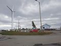
Oulunsalo ferry port. The wind is blowing hard.
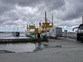
Loading the ferry.
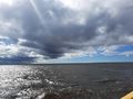
The sky is going to brighten soon.
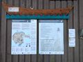
Hailuoto information board.
The main road of the island.
The junction where I diverted towards the hashpoint.
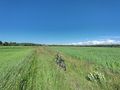
My bicycle parked to the field road, about ten metres to go.
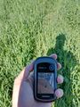
Proof of location.
Proof of date and time.
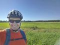
Selfie at the hashpoint.
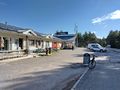
Where we turned back; shop and café in the central village.
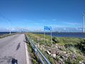
Approaching Hailuoto ferry port.
The ferry has just arrived and will unload soon so we can enter.


Achievements
Kripakko earned the Land geohash achievement
|
Kripakko earned the Consecutive geohash achievement
|