Difference between revisions of "2024-07-24 -37 144"
(An expedition message sent via Geohash Droid for Android.) |
m (Location) |
||
| (5 intermediate revisions by one other user not shown) | |||
| Line 1: | Line 1: | ||
| − | + | {{meetup graticule|date=2024-07-24|lat=-37|lon=144}} | |
| + | == Location == | ||
| + | In a front yard on Maidstone St Altona | ||
| − | [[ | + | == Participants == |
| + | [[User:Johnwrw|John]] | ||
| − | + | == Expedition == | |
| − | + | Couldn't not attempt this one, given the street - the same street as my mum's family home, where my grandma had still lived until moving into aged care earlier this year. Albeit a fair way up the street from grandma's house. | |
| − | + | The point seemed very close to the fence between two front yards in a very well vegetated patch according to the satellite imagery. One front yard had a front fence and had very dense vegetation according to street view, the other had an open grassy front yard mostly without a front fence (it did have a metre or two of fence that I struggle to see the point of) but they also had some trees over by the fence. | |
| − | + | <gallery heights="300px" mode="packed"> | |
| − | + | Image:Westona_geohash.png|Geohash location per google streetview | |
| − | + | </gallery> | |
| + | |||
| + | Depending on signs of life at either of the properties, I wasn't sure I'd feel comfortable trying to reach the point itself, but I had to try. | ||
| − | + | I set off a bit after 3pm, and rode out into rather blustery conditions. Luckily the bluster was from behind me for the most part and I cruised southwards. Rather than riding along the coast, I took the more direct route across the suburbs of West Footscray, Seddon and Yarraville. I crossed the Westgate at the overpass, and continued across South Kingsville and Newport (including crossing Newport Lakes Reserve). I joined the coastal path at JT Gray Reserve (where I played many a game of cricket in my youth). Near the ford, (which I note after a quick google, that [https://www.australiantenders.com.au/tenders/554080/racecourse-road-altona-culvert-ford-crossing-upgrade a tender] was put out earlier this year to upgrade it, seemingly to make it less of a ford), I saw a pelican which was nice to see. | |
| − | |||
| − | -- | ||
| − | + | I left the path at the ford, and joined the road, so I could get onto Civic parade. I rode up the road (a bit too busy for my liking) and soon reached Maidstone St. I turned right and got near the hash. I had to wait several minutes for a break in traffic to cross the road. (The nearest lights to cross the road are literally about 20mins walk away. A roundabout where cars at least need to slow and you could probably force your way across was still 5 mins walk away). | |
| − | |||
| − | + | I eventually cross the road and as expected, from the footpath I'm still a few metres short of the hashpoint. At least the GPS seems to confirm as it seemed from the map, that the point is on the more accessible side of fence between the two yards. The house seemed likely occupied, with two cars parked out the front, (one with a P plate), but the curtains facing out to the street were drawn (understandable to shut out the busy road). I took my chances on their not noticing and ducked up behind their bins to where the point seemed to be. It was shaded by tree, but open enough at ground level. It seemed to be just on a little weed-infested garden bed abutting the fence. I felt I was close enough, though I didn't hang around long enough to get a precisely sub 1m reading. I returned to the footpath, and with no-one emerging from the house I snapped a selfie and continued on my way. In hindsight, given my first incursion aroused no interest from within the house, I could have ducked up again expressly for selfie purposes, having looked after the GPS proof on the first incursion, but I did not. | |
| − | |||
| − | + | With the wind still blustering, in what would have been a headwindish fashion had I ridden home, I opted to get a train back from Westona to Footscray. This train was delayed, as a train out of the city had been delayed by a trespasser somewhere, and there is only a single track on the Altona line, meaning my train had to wait for the other to arrive at Westona to clear the line. In no position to be upset at trespassers, I waited patiently, and eventually got home. | |
| − | |||
== Photos == | == Photos == | ||
| − | < | + | |
| − | Image:2024- | + | <gallery heights="300px" mode="packed"> |
| − | -- | + | |
| − | + | Image:2024-07-24_-37_144_Johnwrw_1721863189141.jpg|Success | |
| + | |||
| + | Image:2024-07-24_-37_144_Johnwrw_1721863206513.jpg|GPS proof | ||
</gallery> | </gallery> | ||
== Achievements == | == Achievements == | ||
{{#vardefine:ribbonwidth|100%}} | {{#vardefine:ribbonwidth|100%}} | ||
| − | + | {{bicycle geohash | |
| + | |date=2024-07-24 | ||
| + | |latitude=-37 | ||
| + | |longitude=144 | ||
| + | |name=[[User:Johnwrw|Johnwrw]] | ||
| + | |distance=21.3km | ||
| + | |bothways=yes | ||
| + | |image= | ||
| + | }} | ||
__NOTOC__ | __NOTOC__ | ||
| − | |||
| − | |||
| − | |||
| − | |||
| − | |||
| − | |||
| − | |||
| − | + | ||
[[Category:Expeditions]] | [[Category:Expeditions]] | ||
| − | + | ||
[[Category:Expeditions with photos]] | [[Category:Expeditions with photos]] | ||
| − | |||
| − | |||
| − | |||
[[Category:Coordinates reached]] | [[Category:Coordinates reached]] | ||
| − | + | {{location|AU|VIC|HB}} | |
| − | |||
| − | |||
| − | |||
| − | |||
| − | |||
| − | |||
| − | |||
| − | |||
| − | |||
| − | |||
| − | |||
| − | |||
| − | |||
Latest revision as of 00:42, 25 July 2024
| Wed 24 Jul 2024 in -37,144: -37.8600000, 144.8109109 geohashing.info google osm bing/os kml crox |
Location
In a front yard on Maidstone St Altona
Participants
Expedition
Couldn't not attempt this one, given the street - the same street as my mum's family home, where my grandma had still lived until moving into aged care earlier this year. Albeit a fair way up the street from grandma's house.
The point seemed very close to the fence between two front yards in a very well vegetated patch according to the satellite imagery. One front yard had a front fence and had very dense vegetation according to street view, the other had an open grassy front yard mostly without a front fence (it did have a metre or two of fence that I struggle to see the point of) but they also had some trees over by the fence.
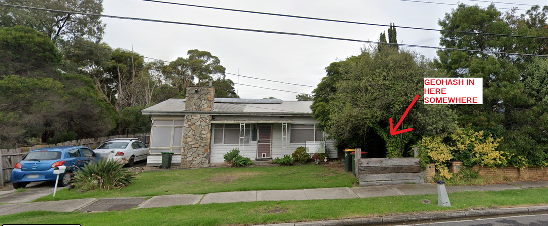
Geohash location per google streetview

Depending on signs of life at either of the properties, I wasn't sure I'd feel comfortable trying to reach the point itself, but I had to try.
I set off a bit after 3pm, and rode out into rather blustery conditions. Luckily the bluster was from behind me for the most part and I cruised southwards. Rather than riding along the coast, I took the more direct route across the suburbs of West Footscray, Seddon and Yarraville. I crossed the Westgate at the overpass, and continued across South Kingsville and Newport (including crossing Newport Lakes Reserve). I joined the coastal path at JT Gray Reserve (where I played many a game of cricket in my youth). Near the ford, (which I note after a quick google, that a tender was put out earlier this year to upgrade it, seemingly to make it less of a ford), I saw a pelican which was nice to see.
I left the path at the ford, and joined the road, so I could get onto Civic parade. I rode up the road (a bit too busy for my liking) and soon reached Maidstone St. I turned right and got near the hash. I had to wait several minutes for a break in traffic to cross the road. (The nearest lights to cross the road are literally about 20mins walk away. A roundabout where cars at least need to slow and you could probably force your way across was still 5 mins walk away).
I eventually cross the road and as expected, from the footpath I'm still a few metres short of the hashpoint. At least the GPS seems to confirm as it seemed from the map, that the point is on the more accessible side of fence between the two yards. The house seemed likely occupied, with two cars parked out the front, (one with a P plate), but the curtains facing out to the street were drawn (understandable to shut out the busy road). I took my chances on their not noticing and ducked up behind their bins to where the point seemed to be. It was shaded by tree, but open enough at ground level. It seemed to be just on a little weed-infested garden bed abutting the fence. I felt I was close enough, though I didn't hang around long enough to get a precisely sub 1m reading. I returned to the footpath, and with no-one emerging from the house I snapped a selfie and continued on my way. In hindsight, given my first incursion aroused no interest from within the house, I could have ducked up again expressly for selfie purposes, having looked after the GPS proof on the first incursion, but I did not.
With the wind still blustering, in what would have been a headwindish fashion had I ridden home, I opted to get a train back from Westona to Footscray. This train was delayed, as a train out of the city had been delayed by a trespasser somewhere, and there is only a single track on the Altona line, meaning my train had to wait for the other to arrive at Westona to clear the line. In no position to be upset at trespassers, I waited patiently, and eventually got home.
Photos
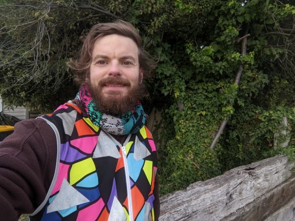
Success
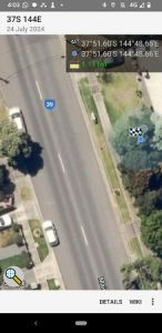
GPS proof


Achievements
Johnwrw earned the Bicycle geohash achievement
|