Difference between revisions of "2024-07-26 -36 144"
([live picture]GPS proof) |
m (Location) |
||
| (5 intermediate revisions by one other user not shown) | |||
| Line 1: | Line 1: | ||
| − | + | {{meetup graticule|date=2024-07-26|lat=-36|lon=144}} | |
| − | |||
| − | |||
| − | |||
| − | |||
| − | |||
| − | |||
| − | |||
| − | |||
== Location == | == Location == | ||
| − | + | On High St/Midland Highway, central Bendigo | |
== Participants == | == Participants == | ||
| − | + | [[User:Johnwrw|John]] | |
| − | |||
== Plans == | == Plans == | ||
| − | + | At 11:30pm the night before I saw that the nearest hash was in the outer eastern suburbs and probably a bit too far for me to bother, though seemingly very gettable on a road. But after my [[2024-05-02_-36_143|Dunolly hash]] in the St Arnaud graticule in May, I had only Bendigo and Colac graticules to go to complete the minesweeper achievement around Melbourne West. Which I why I decided to have a glance at where the Bendigo hash was. And to my great excitement, I saw that it was right in central Bendigo! And also very gettable, in the middle of a road. I had to go! | |
| + | |||
| + | I leapt from my bed! Not to set off there and then in the middle of the night, but to plug my laptop in, so it would be fully charged in the morning, so I could try and still make it a productive PhD day based mainly from a train seat. | ||
== Expedition == | == Expedition == | ||
| − | + | My alarm went off and I leapt from my bed! After a breakfast of eggs and avo on toast I set off to Footscray station on my bike and caught the 9:14 train to Bendigo. I settled into thesisizing and a couple of hours later I was at my destination. I had seen the weather change from my window seat, however, as I headed north and crossed the divide. Sunshine while passing Sunshine station had been replaced by Bendigo's thick low cloud bordering on fog. | |
| − | + | Getting back on my bike I approached the hash in no time. I hadn't been concerned about finding gaps in the traffic to reach the point when I set out, but while I was en route Tom had warned in our geohashing groupchat that it was the busiest road in Bendigo that I was heading for, and to watch out for trams! | |
| − | + | ||
| + | It was indeed a busy road, but not that bad in the late morning/pre-lunch time slot I had arrived in. Over the course of 10 minutes I was able to make three or four excursions towards the point. I eventually got a satisfactory gps reading without being interrupted by traffic appearing, and also got the requisite selfie. That's Bendigo done for the minesweeper, just Colac to go! | ||
| + | |||
| + | I now had a bit over an hour to kill until the next train back to Melbourne. I headed into the central shopping area, paying my respects as I passed to the giant BENDIGO sign at the corner of the gardens. In the mall I found some sushi and some live music to entertain me as the sushi was ingested. | ||
| + | |||
| + | On the train back to Melbourne, I saw in the groupchat that the gettability of the Melbourne East point had been noticed, and I admitted that I was considering heading straight there for a second geohash in the day. It may not have been worth an expedition on its own, but to form part of a multihash... that's a different proposition. It was why I had bothered lugging my bike to Bendigo even though the hash there was very much in walking distance; I had my eye on the ride to [[2024-07-26_-37_145|Wonga Park...]] | ||
== Photos == | == Photos == | ||
| − | < | + | |
| − | Image:2024- | + | <gallery heights="300px" mode="packed"> |
| − | -- | + | |
| − | + | Image:2024-07-26_-36_144_Johnwrw_1721990999963.jpg|Cathedral in fog | |
| + | |||
| + | Image:2024-07-26_-36_144_Johnwrw_1721991018566.jpg|Success! | ||
| + | |||
| + | Image:2024-07-26_-36_144_Johnwrw_1721991031379.jpg|Bendigo | ||
| + | |||
| + | Image:2024-07-26_-36_144_Johnwrw_1721991048508.jpg|Live music | ||
Image:2024-07-26_-36_144_Johnwrw_1721990964454.jpg|GPS proof | Image:2024-07-26_-36_144_Johnwrw_1721990964454.jpg|GPS proof | ||
| Line 35: | Line 39: | ||
== Achievements == | == Achievements == | ||
{{#vardefine:ribbonwidth|100%}} | {{#vardefine:ribbonwidth|100%}} | ||
| − | + | {{Minesweeper geohash | |
| + | |||
| + | | graticule = Melbourne West, Australia | ||
| + | | ranknumber = 7 | ||
| + | | n = true | ||
| + | | ne = true | ||
| + | | e = true | ||
| + | | s = true | ||
| + | | se = true | ||
| + | | w = true | ||
| + | | nw = true | ||
| + | | name = John | ||
| + | }} | ||
| + | |||
| + | {{Public transport geohash | ||
| + | |||
| + | | latitude = -36 | ||
| + | | longitude = 144 | ||
| + | | date = 2024-07-26 | ||
| + | | busline = V-Line | ||
| + | | name = John | ||
| + | }} | ||
__NOTOC__ | __NOTOC__ | ||
| − | |||
| − | |||
| − | |||
| − | |||
| − | |||
| − | |||
| − | |||
| − | + | ||
| + | |||
[[Category:Expeditions]] | [[Category:Expeditions]] | ||
| − | + | ||
[[Category:Expeditions with photos]] | [[Category:Expeditions with photos]] | ||
| − | |||
| − | |||
| − | |||
| − | |||
| − | |||
| − | |||
| − | |||
| − | |||
| − | |||
| − | |||
| − | |||
| − | + | [[Category:Coordinates reached]] | |
| − | [[Category: | + | {{location|AU|VIC|GB}} |
| − | |||
| − | |||
Latest revision as of 12:42, 26 July 2024
| Fri 26 Jul 2024 in -36,144: -36.7618096, 144.2724409 geohashing.info google osm bing/os kml crox |
Location
On High St/Midland Highway, central Bendigo
Participants
Plans
At 11:30pm the night before I saw that the nearest hash was in the outer eastern suburbs and probably a bit too far for me to bother, though seemingly very gettable on a road. But after my Dunolly hash in the St Arnaud graticule in May, I had only Bendigo and Colac graticules to go to complete the minesweeper achievement around Melbourne West. Which I why I decided to have a glance at where the Bendigo hash was. And to my great excitement, I saw that it was right in central Bendigo! And also very gettable, in the middle of a road. I had to go!
I leapt from my bed! Not to set off there and then in the middle of the night, but to plug my laptop in, so it would be fully charged in the morning, so I could try and still make it a productive PhD day based mainly from a train seat.
Expedition
My alarm went off and I leapt from my bed! After a breakfast of eggs and avo on toast I set off to Footscray station on my bike and caught the 9:14 train to Bendigo. I settled into thesisizing and a couple of hours later I was at my destination. I had seen the weather change from my window seat, however, as I headed north and crossed the divide. Sunshine while passing Sunshine station had been replaced by Bendigo's thick low cloud bordering on fog.
Getting back on my bike I approached the hash in no time. I hadn't been concerned about finding gaps in the traffic to reach the point when I set out, but while I was en route Tom had warned in our geohashing groupchat that it was the busiest road in Bendigo that I was heading for, and to watch out for trams!
It was indeed a busy road, but not that bad in the late morning/pre-lunch time slot I had arrived in. Over the course of 10 minutes I was able to make three or four excursions towards the point. I eventually got a satisfactory gps reading without being interrupted by traffic appearing, and also got the requisite selfie. That's Bendigo done for the minesweeper, just Colac to go!
I now had a bit over an hour to kill until the next train back to Melbourne. I headed into the central shopping area, paying my respects as I passed to the giant BENDIGO sign at the corner of the gardens. In the mall I found some sushi and some live music to entertain me as the sushi was ingested.
On the train back to Melbourne, I saw in the groupchat that the gettability of the Melbourne East point had been noticed, and I admitted that I was considering heading straight there for a second geohash in the day. It may not have been worth an expedition on its own, but to form part of a multihash... that's a different proposition. It was why I had bothered lugging my bike to Bendigo even though the hash there was very much in walking distance; I had my eye on the ride to Wonga Park...
Photos
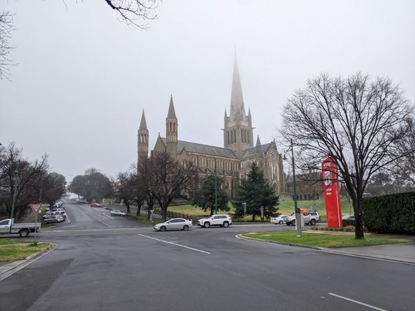
Cathedral in fog
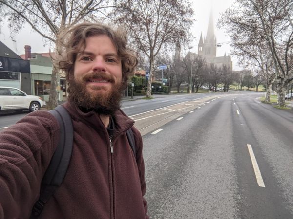
Success!
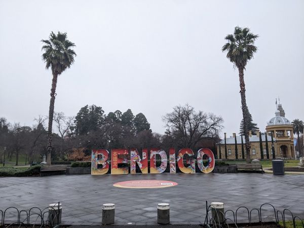
Bendigo
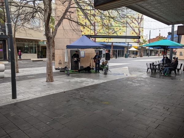
Live music
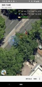
GPS proof


Achievements
John achieved level 7 of the Minesweeper Geohash achievement
|
John earned the Public transport geohash achievement
|